Report on Bagana (Papua New Guinea) — September 2022

Bulletin of the Global Volcanism Network, vol. 47, no. 9 (September 2022)
Managing Editor: Benjamin Andrews.
Edited by Kadie L. Bennis.
Bagana (Papua New Guinea) Ash plumes and thermal activity with possible lava flows during September 2021-August 2022
Please cite this report as:
Global Volcanism Program, 2022. Report on Bagana (Papua New Guinea) (Bennis, K.L., and Andrews, B., eds.). Bulletin of the Global Volcanism Network, 47:9. Smithsonian Institution.
Bagana
Papua New Guinea
6.137°S, 155.196°E; summit elev. 1855 m
All times are local (unless otherwise noted)
Bagana is a remote volcano that has had historical eruptions dating back to 1842 and is located in central Bougainville Island in Papua New Guinea. Frequent eruptive activity is characterized by non-explosive lava effusions that maintain a small lava dome in the summit crater. Occasional explosive activity has occurred, which has produced pyroclastic flows. The current eruption period began in February 2000 and has consisted of ongoing thermal anomalies, possible lava flows, and gas-and-ash emissions (BGVN 46:09). This report covers activity during September 2021 through August 2022 based on information from the Darwin Volcanic Ash Advisory Center (VAAC) and various satellite data.
Thermal activity of variable intensity persisted throughout the reporting period, based on satellite data. MIROVA reported consistent thermal anomalies throughout the reporting period (figure 41) based upon Sentinel-2 MODIS Thermal Volcanic Activity. According to the MODVOLC thermal algorithm, a total of 13 thermal anomalies were detected on 1, 19, and 24 September 2021, 12 and 17 October, 11 November, 24, 25, and 29 April 2022, and 2, 13, and 22 May. Some of this thermal activity was reflected in Sentinel-2 infrared satellite images, which showed summit crater incandescence, as well as incandescent material, possibly from cooling lava flows, occasionally descending the NW flank, such as on 24 September 2021, 8 November, 23 December, 1 and 6 February 2022, 12 and 22 May, and 6 July (figure 42). Occasional gas-and-steam emissions were visible in satellite images (figure 43). Distinct sulfur dioxide plumes were relatively frequent throughout the reporting period. The column abundances, as measured by the TROPOMI instrument on the Sentinel-5P satellite, often exceeded two Dobson Units (DUs) (figure 44), and the plumes drifted in different directions.
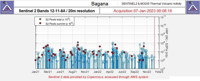 |
Figure 41. Frequent and consistent thermal anomalies (red dots) were detected at Bagana during September 2021 through August 2022 as recorded by the Sentinel-2 MODIS Thermal Volcanic Activity data (bands 12, 11, 8A). The strength of these anomalies varied. Courtesy of MIROVA. |
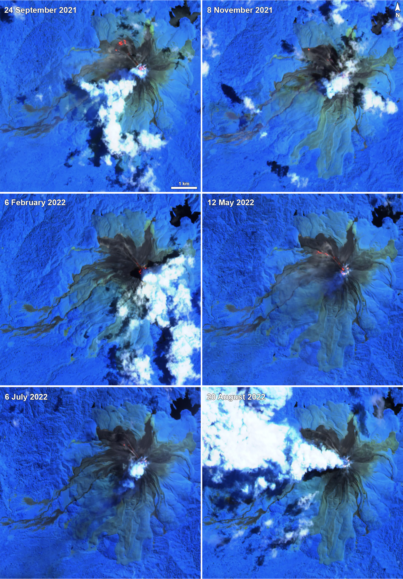 |
Figure 42. Sentinel-2 infrared satellite images showing thermal incandescence in both the summit crater and on the dominantly NW flank of Bagana on 24 September 2021 (top left), 8 November 2021 (top right), 6 February 2022 (middle left), 12 May 2022 (middle right), 6 July 2022 (bottom left), and 20 August 2022 (bottom right). Occasional white gas-and-steam emissions were also visible. In each of these images except on 20 August, traces of incandescent material are visible on the NW flank. Sentinel-2 images with "Atmospheric penetration" (bands 12, 11, 8A) rendering. Courtesy of Sentinel Hub Playground. |
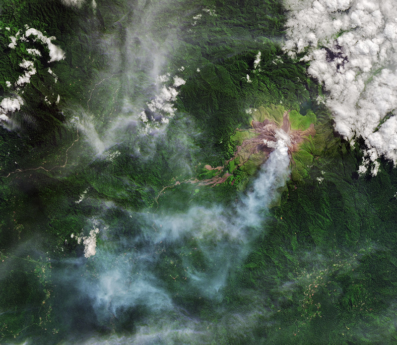 |
Figure 43. Satellite image of Bagana showing a clear view of the summit and a white gas-and-steam plume drifting SW on 28 May 2022. Courtesy of Joshua Stevens (NASA Earth Observatory). |
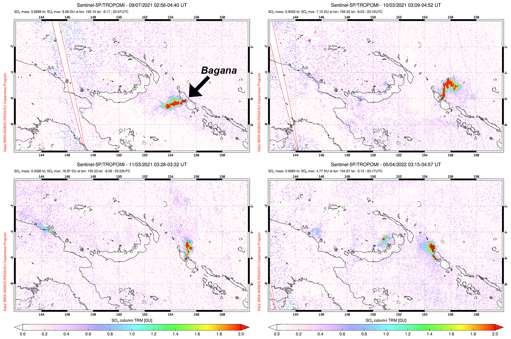 |
Figure 44. Distinct sulfur dioxide plumes were detected from Bagana on 7 September 2021 (top left), 3 October 2021 (top right), 3 November 2021 (bottom left), and 4 May 2022 (bottom right). Each of these plumes exceeded 2 Dobson Units (DUs) and drifted in different directions. Data is from the TROPOMI instrument on the Sentinel-5P satellite. Courtesy of NASA Global Sulfur Dioxide Monitoring Page. |
The Darwin VAAC issued a total of seven notices during the reporting period. On October 2021 the reported ash plume rose to 2.1 km altitude and drifted NE based on satellite and wind model data. On 27 November continuous ash plumes also rose to 2.1 km altitude and drifted NW. Minor gas-and-steam emissions were also noted. On 22 August an ash plume rose to 3 km altitude and drifted SW, accompanied by continuous gas-and-steam emissions.
Geological Summary. Bagana volcano, in a remote portion of central Bougainville Island, is frequently active. This massive symmetrical cone was largely constructed by an accumulation of viscous andesitic lava flows. The entire edifice could have been constructed in about 300 years at its present rate of lava production. Eruptive activity is characterized by non-explosive effusion of viscous lava that maintains a small lava dome in the summit crater, although occasional explosive activity produces pyroclastic flows. Lava flows with tongue-shaped lobes up to 50 m thick and prominent levees descend the flanks on all sides.
Information Contacts: Darwin Volcanic Ash Advisory Centre (VAAC), Bureau of Meteorology, Northern Territory Regional Office, PO Box 40050, Casuarina, NT 0811, Australia (URL: http://www.bom.gov.au/info/vaac/); MIROVA (Middle InfraRed Observation of Volcanic Activity), a collaborative project between the Universities of Turin and Florence (Italy) supported by the Centre for Volcanic Risk of the Italian Civil Protection Department (URL: http://www.mirovaweb.it/); Hawai'i Institute of Geophysics and Planetology (HIGP) - MODVOLC Thermal Alerts System, School of Ocean and Earth Science and Technology (SOEST), Univ. of Hawai'i, 2525 Correa Road, Honolulu, HI 96822, USA (URL: http://modis.higp.hawaii.edu/); NASA Global Sulfur Dioxide Monitoring Page, Atmospheric Chemistry and Dynamics Laboratory, NASA Goddard Space Flight Center (NASA/GSFC), 8800 Greenbelt Road, Goddard, Maryland, USA (URL: https://so2.gsfc.nasa.gov/); Sentinel Hub Playground (URL: https://www.sentinel-hub.com/explore/sentinel-playground); Joshua Stevens, NASA Earth Observatory, EOS Project Science Office, NASA Goddard Space Flight Center, Goddard, Maryland 20771, USA (URL: http://earthobservatory.nasa.gov/).