Report on Langila (Papua New Guinea) — October 2022

Bulletin of the Global Volcanism Network, vol. 47, no. 10 (October 2022)
Managing Editor: Benjamin Andrews.
Edited by Kadie L. Bennis.
Langila (Papua New Guinea) Weak thermal activity, occasional ash plumes, and sulfur dioxide plumes during January-September 2022
Please cite this report as:
Global Volcanism Program, 2022. Report on Langila (Papua New Guinea) (Bennis, K.L., and Andrews, B., eds.). Bulletin of the Global Volcanism Network, 47:10. Smithsonian Institution.
Langila
Papua New Guinea
5.525°S, 148.42°E; summit elev. 1330 m
All times are local (unless otherwise noted)
Langila is located at the W tip of Papua New Guinea’s New Britain Island and consists of a group of four small overlapping cones. Documented eruptions date back to the 19th century and were characterized by frequent mild-to-moderate explosive eruptions with ash emissions originating from three active summit craters. The current eruption period began in October 2015 and has recently consisted of intermittent, low-level thermal activity, ash plumes, and sulfur dioxide plumes (BGVN 47:02). Similar low activity continued during this report that covers January through September 2022 using information primarily from the Darwin Volcanic Ash Advisory Center (VAAC) and satellite images.
Activity was relatively low during the reporting interval, consisting primarily of intermittent thermal activity. The MIROVA (Middle InfraRed Observation of Volcanic Activity) graph showed low-power thermal anomalies mostly occurring from late April through September 2022 (figure 28). There were two anomalies detected during early-to-mid January and then a break in detected activity occurred during February through late April. Two small hotspots were detected during late April. There were five hotspots detected during May, four during June, eight during July, six during August, and eight during September. Some of this activity was also visible on clear weather days in Sentinel-2 infrared satellite imagery during April through September, sometimes accompanied by gas-and-steam emissions (figure 29).
 |
Figure 28. Intermittent low-power thermal activity at Langila was shown in the MIROVA graph (Log Radiative Power) during January and late April through September 2022. There was a break in detected activity during mid-January through late April 2022. Courtesy of MIROVA. |
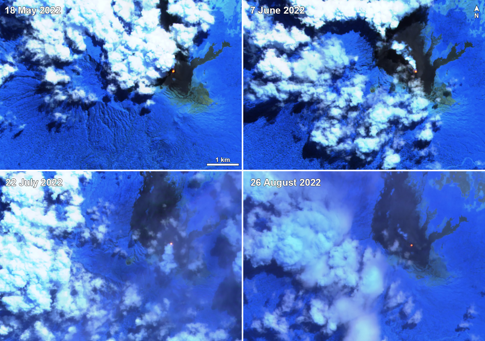 |
Figure 29. Sentinel-2 infrared satellite imagery showed a single thermal anomaly at Langila on 18 May 2022 (top left), 7 June (top right), 22 July (bottom left), and 26 August (bottom right), sometimes accompanied by gas-and-steam emissions, as seen on 7 June and 22 July. Sentinel-2 satellite images with “Atmospheric penetration” (bands 12, 11, 8A) rendering. Courtesy of Sentinel Hub Playground. |
The NASA Global Sulfur Dioxide page, which shows data from the TROPOMI instrument on the Sentinel-5P satellite, showed occasional weak sulfur dioxide plumes during March through May 2022 that drifted in different directions (figure 30). Occasional ash plumes were reported by the Darwin VAAC beginning on 9 February when ash plumes were visible in HIMAWARI-8 satellite images and rose to 4.3 km altitude and drifted SW. On 6 March an ash plume rose to 3 km altitude and drifted SE; it dissipated within an hour. Another plume on 8 March rose to 3.7 km altitude and drifted NW; it dissipated within three hours. On 24 April an ash plume rose to 2.1 km altitude and drifted SW, before dissipating within 5.5 hours.
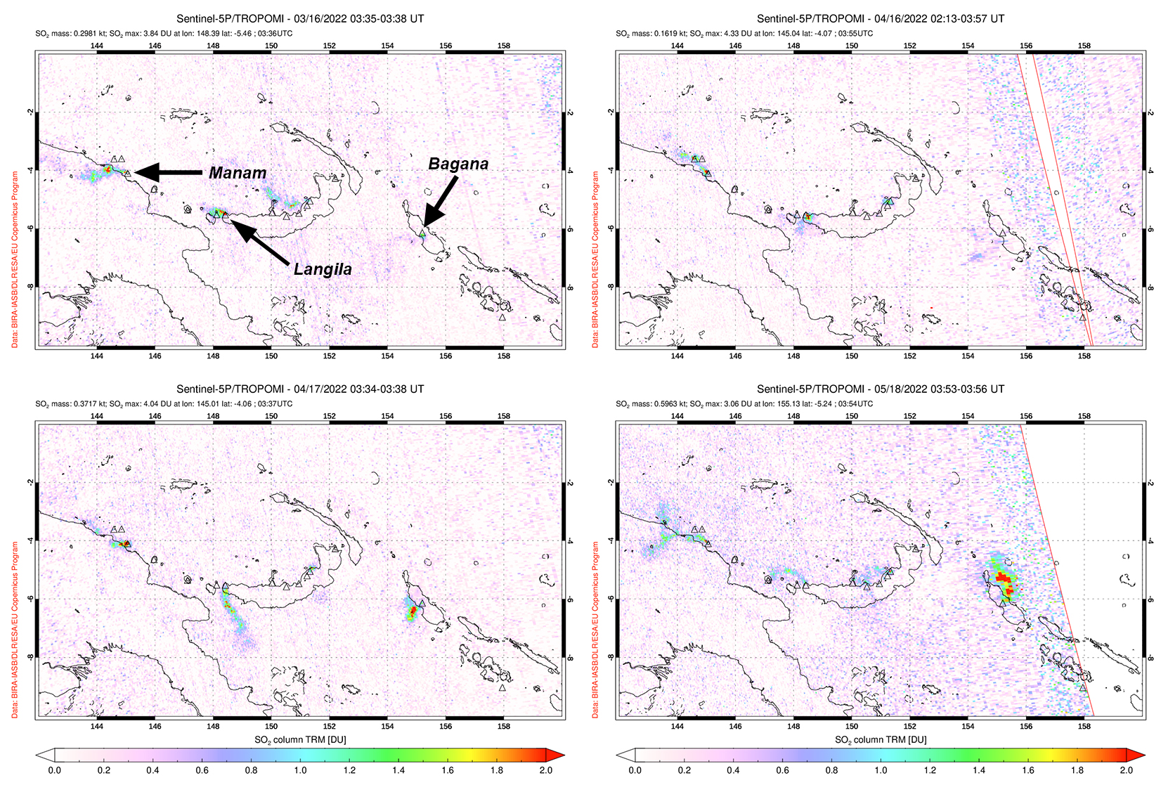 |
Figure 30. Small sulfur dioxide plumes were visible above Langila based on data from the TROPOMI instrument on the Sentinel-5P satellite. Plumes drifted NW on 16 March 2022 (top left), SW on 16 April (top right), 17 April (bottom left), and 18 May 2022 (bottom right). Plumes were also intermittently visible from Manam (to the W) and Bagana (to the E). Courtesy of the NASA Global Sulfur Dioxide Monitoring Page. |
Geological Summary. Langila, one of the most active volcanoes of New Britain, consists of a group of four small overlapping composite basaltic-andesitic cones on the lower E flank of the extinct Talawe volcano in the Cape Gloucester area of NW New Britain. A rectangular, 2.5-km-long crater is breached widely to the SE; Langila was constructed NE of the breached crater of Talawe. An extensive lava field reaches the coast on the N and NE sides of Langila. Frequent mild-to-moderate explosive eruptions, sometimes accompanied by lava flows, have been recorded since the 19th century from three active craters at the summit. The youngest and smallest crater (no. 3 crater) was formed in 1960 and has a diameter of 150 m.
Information Contacts: Darwin Volcanic Ash Advisory Centre (VAAC), Bureau of Meteorology, Northern Territory Regional Office, PO Box 40050, Casuarina, NT 0811, Australia (URL: http://www.bom.gov.au/info/vaac/); MIROVA (Middle InfraRed Observation of Volcanic Activity), a collaborative project between the Universities of Turin and Florence (Italy) supported by the Centre for Volcanic Risk of the Italian Civil Protection Department (URL: http://www.mirovaweb.it/); NASA Global Sulfur Dioxide Monitoring Page, Atmospheric Chemistry and Dynamics Laboratory, NASA Goddard Space Flight Center (NASA/GSFC), 8800 Greenbelt Road, Goddard, Maryland, USA (URL: https://so2.gsfc.nasa.gov/); Sentinel Hub Playground (URL: https://www.sentinel-hub.com/explore/sentinel-playground).