Report on Ambae (Vanuatu) — October 2022

Bulletin of the Global Volcanism Network, vol. 47, no. 10 (October 2022)
Managing Editor: Edward Venzke.
Research and preparation by Paul Berger.
Ambae (Vanuatu) Significant explosions during December 2021-February 2022 build new cone in summit crater lake
Please cite this report as:
Global Volcanism Program, 2022. Report on Ambae (Vanuatu) (Venzke, E., ed.). Bulletin of the Global Volcanism Network, 47:10. Smithsonian Institution.
Ambae
Vanuatu
15.389°S, 167.835°E; summit elev. 1496 m
All times are local (unless otherwise noted)
Ambae is a large basaltic shield volcano in Vanuatu that has had periodic phreatic and pyroclastic explosions since the 16th century. A large eruption more than 400 years ago resulted in a volcanic cone within the summit crater that is now filled by Lake Voui; approximately the same size, Lake Manaro fills the western third of the caldera. The September 2017-October 2018 eruption included large ash explosions with heavy ashfall and plumes that rose to 13.7 km altitude, lava fountaining, minor lava flows, incandescence, lahars, sulfur dioxide plumes, and thermal anomalies (BGVN 43:02, 43:07). The currently active vent is within the pyroclastic cone that grew in the lake in mid-September 2017 (BGVN 43:02), eventually splitting Lake Voui into two sections (BGVN 43:07). A new explosive eruption period began on 5 December 2021 (BGVN 47:03). This report covers activity from January-September 2022, with information provided by the Vanuatu Meteorology and Geo-Hazards Department (VMGD) and satellite data.
During the reporting period, the Alert Level remained at 2 (on a scale of 0-5), which signifies “Danger around the crater rim and specific area, notable/large unrest, considerable possibility of eruption and also chance of flank eruption”. According to VMGD, during January-September 2022 weather clouds often prevented observations, but the cone in Lake Voui continued to grow and produce gas-and-steam and ash emissions, and plumes occasionally caused light ashfall on nearby villages. Explosions of wet tephra rose above the lake surface but remained within the caldera.
VMGD reported that on 2 January 2022 ash plumes were seen drifting ENE at 1730 and 1830. On 3 January at 0600, a gas-and-ash plume rose 5 km, though only the lower portion of the plume contained ash (figure 96); at 0730 another ash plume rose almost 1.6 km. Additional significant ash plumes were observed on 16 January and at 0845 on 5 February. The Wellington Volcanic Ash Advisory Centre reported that webcam images on 17 February showed ash emissions rising to an altitude of 3 km and drifting WSW. A notable sulfur dioxide plume was also detected that day by the TROPOMI instrument aboard the Sentinel-5P satellite (figure 97).
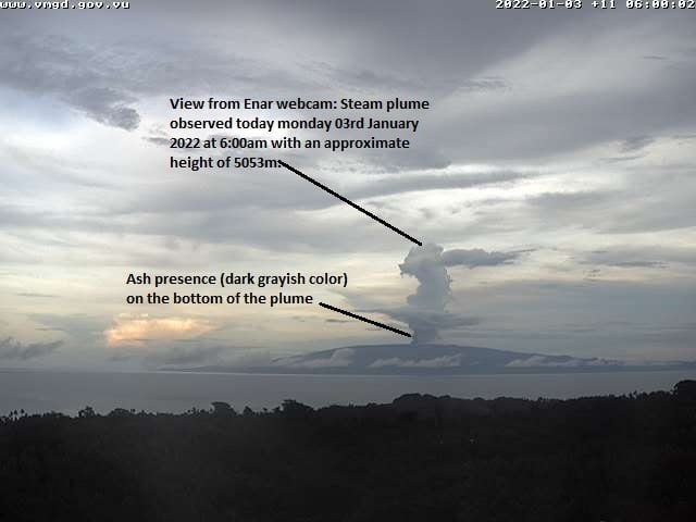 |
Figure 96. A gas-and-ash plume rises above Ambae on 3 January 2022 at 0600, as seen in this webcam image annotated by VMGD. Courtesy of VMGD. |
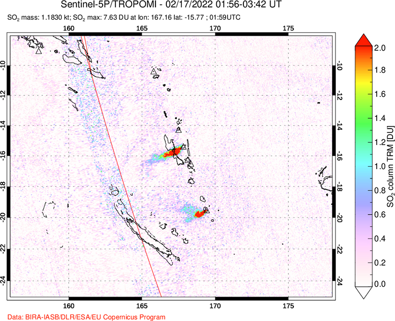 |
Figure 97. Image showing a strong sulfur dioxide plume from Ambae (center) on 17 February 2022, as detected by the TROPOMI instrument aboard the Sentinel-5P satellite. Yasur (bottom) was also venting a strong sulfur dioxide plume on the same day. Courtesy of the NASA Global Sulfur Dioxide Monitoring Page. |
Sentinel-2 images show that the growing pyroclastic cone divided the W section of Lake Voui into two parts by 24 March 2022 (figure 98). During the reporting period, the MIROVA system recorded several hotspots, mostly in early January 2022, and one in early May 2022. VMGD did not issue reports about Ambae after 27 May, noting continuing gas-and-ash emissions, until 31 August 2022, when they noted gas emissions with “possible ashes” included. Satellite imagery on 10 September showed no morphological changes to the lakes since late March.
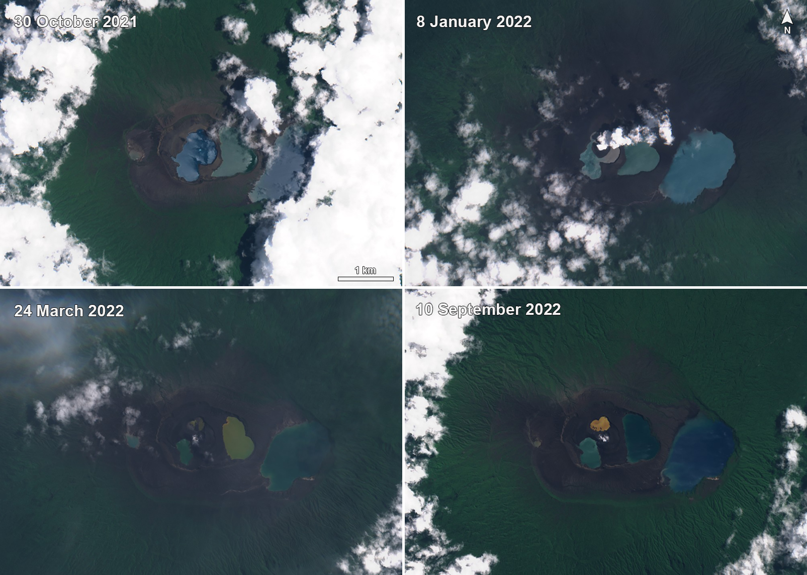 |
Figure 98. Sentinel-2 images of Ambae show the changing features and sections of Lake Voui (center), with Lake Manaro to the E (right) and smaller Lake Ngoru to the W (left). The image from 30 October 2021 shows Lake Voui divided into two sections from earlier activity. The 8 January 2022 image shows a new pyroclastic cone in the western section from activity since early December 2021. By 24 March 2022 ongoing eruptions had divided the western part of Lake Voui into at least two smaller lakes. Images use natural color rendering (bands 4, 3, 2). Courtesy of Sentinel Hub Playground. |
Geological Summary. The island of Ambae, also known as Aoba, is a massive 2,500 km3 basaltic shield that is the most voluminous volcano of the New Hebrides archipelago. A pronounced NE-SW-trending rift zone with numerous scoria cones gives the 16 x 38 km island an elongated form. A broad pyroclastic cone containing three crater lakes (Manaro Ngoru, Voui, and Manaro Lakua) is located at the summit within the youngest of at least two nested calderas, the largest of which is 6 km in diameter. That large central edifice is also called Manaro Voui or Lombenben volcano. Post-caldera explosive eruptions formed the summit craters about 360 years ago. A tuff cone was constructed within Lake Voui (or Vui) about 60 years later. The latest known flank eruption, about 300 years ago, destroyed the population of the Nduindui area near the western coast.
Information Contacts: Geo-Hazards Division, Vanuatu Meteorology and Geo-Hazards Department (VMGD), Ministry of Climate Change Adaptation, Meteorology, Geo-Hazards, Energy, Environment and Disaster Management, Private Mail Bag 9054, Lini Highway, Port Vila, Vanuatu (URL: http://www.vmgd.gov.vu/, https://www.facebook.com/VanuatuGeohazardsObservatory/); Wellington Volcanic Ash Advisory Centre (VAAC), Meteorological Service of New Zealand Ltd (MetService), PO Box 722, Wellington, New Zealand (URL: http://www.metservice.com/vaac/, http://www.ssd.noaa.gov/VAAC/OTH/NZ/messages.html); MIROVA (Middle InfraRed Observation of Volcanic Activity), a collaborative project between the Universities of Turin and Florence (Italy) supported by the Centre for Volcanic Risk of the Italian Civil Protection Department (URL: http://www.mirovaweb.it/); Global Sulfur Dioxide Monitoring Page, Atmospheric Chemistry and Dynamics Laboratory, NASA Goddard Space Flight Center (NASA/GSFC), 8800 Greenbelt Road, Goddard, Maryland, USA (URL: https://so2.gsfc.nasa.gov/); Sentinel Hub Playground (URL: https://www.sentinel-hub.com/explore/sentinel-playground).