Report on Merapi (Indonesia) — October 2022

Bulletin of the Global Volcanism Network, vol. 47, no. 10 (October 2022)
Managing Editor: Benjamin Andrews.
Edited by Kadie L. Bennis.
Merapi (Indonesia) Frequent avalanches, crater incandescence, and occasional pyroclastic flows
Please cite this report as:
Global Volcanism Program, 2022. Report on Merapi (Indonesia) (Bennis, K.L., and Andrews, B., eds.). Bulletin of the Global Volcanism Network, 47:10. Smithsonian Institution.
Merapi
Indonesia
7.54°S, 110.446°E; summit elev. 2910 m
All times are local (unless otherwise noted)
Merapi is located just north of the major city of Yogyakarta in central Java, Indonesia. Pyroclastic flows and lahars accompanying growth and collapse of the steep-sided active summit lava dome have occurred on the western-to-southern flanks, causing many fatalities within the last 20 years. The current eruption period began in late December 2020 and has more recently consisted of dome growth, pyroclastic flows, avalanches, and ash emissions (BGVN 47:03). This report covers activity comprising avalanches and pyroclastic flows during March through September 2022 using information primarily from Balai Penyelidikan dan Pengembangan Teknologi Kebencanaan Geologi (BPPTKG), the Center for Research and Development of Geological Disaster Technology, a branch of PVMBG which specifically monitors Merapi. Additional information comes from the Pusat Vulkanologi dan Mitigasi Bencana Geologi (PVMBG, also known as Indonesian Center for Volcanology and Geological Hazard Mitigation, CVGHM), MAGMA Indonesia, the Darwin Volcanic Ash Advisory Centre (VAAC), and various satellite data.
BPPTKG reported that during March near-daily white gas-and-steam emissions were observed 10-400 m above the summit and as many as 38 daily incandescent avalanches of material descended 1.8-2 km to the SW/W and occasionally 1-2.5 km to the SE (table 23). Shallow volcanic earthquakes were also detected throughout the month. On 7 March a pyroclastic flow was reported descending 2 km on the SW flank, accompanied by 15 incandescent avalanches of material that descended 1.8 km on the SW flank. On 9 March, five pyroclastic flows traveled as far as 5 km down the SE flank at 2318, 2329, 2338, 2344, and 2353. On 9 March the Darwin VAAC reported an ash plume rose to 6 km altitude and drifted NNW, based on ground observations from CVGHM; it was not visible in satellite imagery due to cloud cover. On 10 March, 13 pyroclastic flows were observed traveling 2-2.5 km down the SE flank; 17 avalanches traveled 1.5 km to the SE and 21 avalanches traveled 2 km to the SW. A strong explosion was heard on 18 March, accompanied by a single incandescent avalanche descending 1 km on the SW flank. On 19 March at 1617 a pyroclastic flow traveled 2.5 km to the SW. During the morning of 28 March resuspended ash rose to 3 km altitude and drifted E, based on webcam images. Two pyroclastic flows were observed on 28 March traveling 2.5 km SW.
Table 23. Monthly summary of avalanches and avalanche distances recorded at Merapi during March through September 2022. The number of reported avalanches does not include instances where possible avalanches were heard, because they could not be visually confirmed due to inclement weather. Data courtesy of BPPTKG (March-September 2022 daily reports).
| Month | Average number of avalanches per day | Distance avalanches traveled (km) |
| Mar 2022 | 14 | 1-2.5 |
| Apr 2022 | 18 | 1-2 |
| May 2022 | 16 | 1.2-2 |
| Jun 2022 | 10 | 1.2-1.9 |
| Jul 2022 | 6 | 1-2 |
| Aug 2022 | 4 | 1.2-2 |
| Sep 2022 | 2.6 | 1-2 |
Similar activity during April and May with white gas-and-steam emissions rising 10-500 m above the summit. As many as 45 daily incandescent avalanches of material ranged from 2 to 45, traveling 1-2 km dominantly down the SW flank. Occasional shallow volcanic earthquakes continued throughout the month. On 19 April a pyroclastic flow was reported moving 2 km to the SW (figure 127). On 8 and 10 May pyroclastic flows were observed descending 2 km and 1.8 km on the SW flank, respectively (figure 128). A pyroclastic flow on 19 May traveled 2.5 km SW. Three pyroclastic flows were reported on 26 May that traveled 1.6-2 km SW.
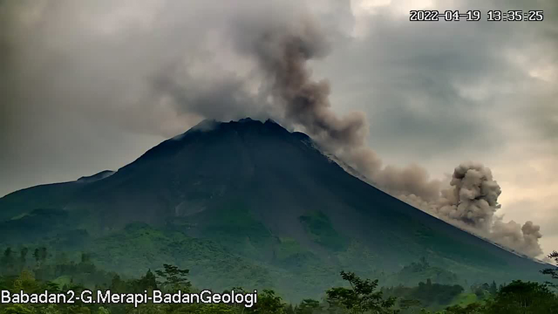 |
Figure 127. Webcam image of a pyroclastic flow descending the SW flank of Merapi as far as 2 km around 1335 on 19 April 2022. Courtesy of BPPTKG. |
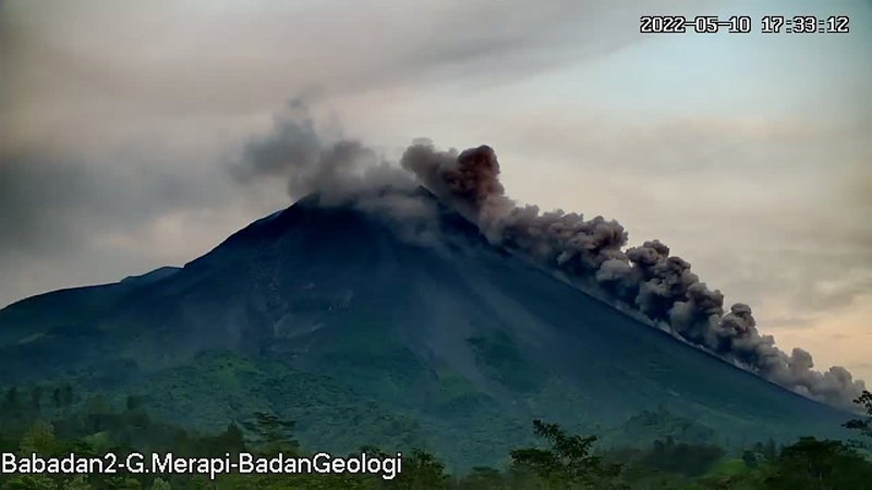 |
Figure 128. Webcam image of a pyroclastic flow descending the SW flank of Merapi as far as 2 km around 1733 on 10 May 2022. Courtesy of BPPTKG. |
During June and July white gas-and-steam emissions rose 20-150 m above the summit and as many as 22 daily incandescent avalanches of material descended as far as 2 km dominantly on the SW flank (figure 129); after June, the number of avalanches decreased compared to the previous months. Shallow volcanic earthquakes continued to be detected.
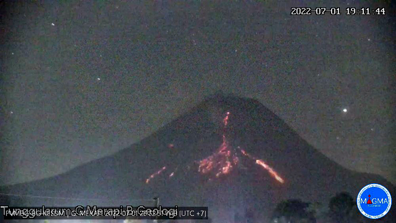 |
Figure 129. Webcam image of an incandescent avalanche descending Merapi at 1911 on 1 July 2022. Courtesy of MAGMA Indonesia. |
Activity continued during August and September. White gas-and-steam emissions rose 15-200 m above the summit and as many as 15 daily incandescent avalanches of material descended as far as 1.8 km dominantly on the SW flank. Cloudy weather during late August and into September often prevented clear views of the summit, so oftentimes avalanches were audible but not visible. Deep and shallow volcanic earthquakes persisted. On 4 August an avalanche descended the NW flank as far as 1.5 km.
The MODIS Log Radiative Power graph produced by the MIROVA (Middle InfraRed Observation of Volcanic Activity) project showed intermittent low-to-moderate power thermal activity occurring during March through early August 2022 (figure 130). The power of those anomalies fluctuated; three small peaks in activity were detected during early March, early April, and late May. No thermal activity was detected during September. Two of those peaks were also reflected in MODVOLC Thermal data. A total of eight thermal hotspots were detected on 15 April, 22 May, and 2 June 2022. This thermal activity was also captured in Sentinel-2 infrared satellite imagery during late March through early July 2022, where incandescent material was visible primarily on the SW flank (figure 131).
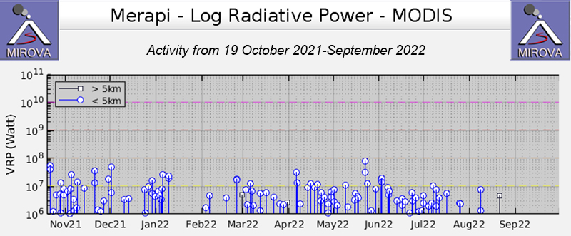 |
Figure 130. Intermittent low-to-moderate-power thermal anomalies at Merapi occurred during March through early August 2022, according to this MIROVA graph (Log Radiative Power). The power of those anomalies fluctuated, with at least three distinct peaks occurring in early March, early April, and late May 2022. No thermal activity was detected during September. Courtesy of MIROVA. |
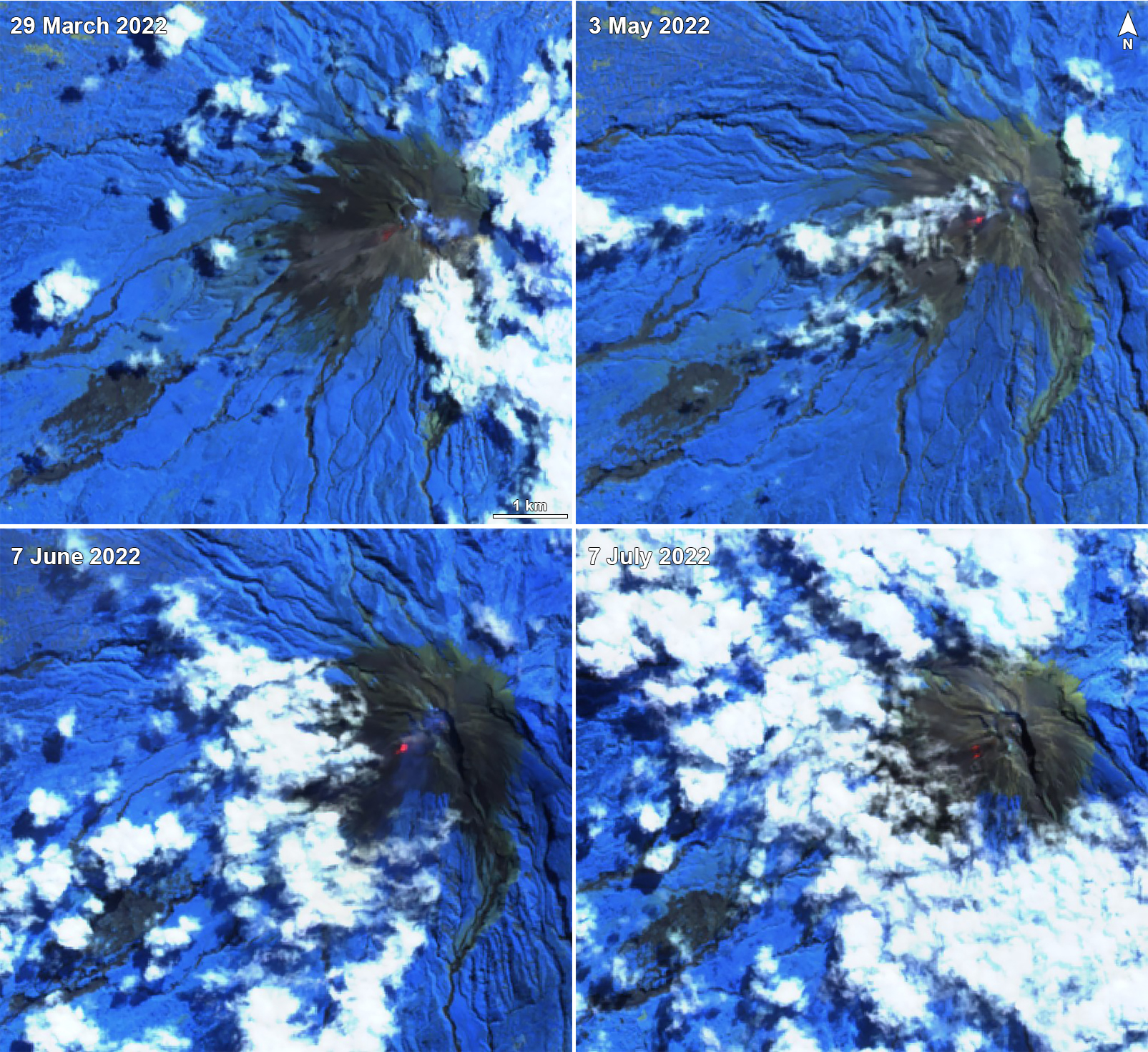 |
Figure 131. Weak-to-moderate incandescence and possible block-and-ash flows were visible on clear weather days near the summit crater of Merapi, dominantly on the SW flank. Examples from Sentinel-2 infrared satellite imagery are shown here on 29 March 2022 (top left), 3 May 2022 (top right), 7 June 2022 (bottom left), and 7 July 2022 (bottom right). Occasional gas-and-steam emissions (light blue) accompanied this activity. Images use Atmospheric penetration rendering (bands 12, 11, 8a). Courtesy of Sentinel Hub Playground. |
Geological Summary. Merapi, one of Indonesia's most active volcanoes, lies in one of the world's most densely populated areas and dominates the landscape immediately north of the major city of Yogyakarta. It is the youngest and southernmost of a volcanic chain extending NNW to Ungaran volcano. Growth of Old Merapi during the Pleistocene ended with major edifice collapse perhaps about 2,000 years ago, leaving a large arcuate scarp cutting the eroded older Batulawang volcano. Subsequent growth of the steep-sided Young Merapi edifice, its upper part unvegetated due to frequent activity, began SW of the earlier collapse scarp. Pyroclastic flows and lahars accompanying growth and collapse of the steep-sided active summit lava dome have devastated cultivated lands on the western-to-southern flanks and caused many fatalities.
Information Contacts: Balai Penyelidikan dan Pengembangan Teknologi Kebencanaan Geologi (BPPTKG), Center for Research and Development of Geological Disaster Technology (URL: http://merapi.bgl.esdm.go.id/, Twitter: @BPPTKG); MAGMA Indonesia, Kementerian Energi dan Sumber Daya Mineral (URL: https://magma.esdm.go.id/v1); Pusat Vulkanologi dan Mitigasi Bencana Geologi (PVMBG, also known as Indonesian Center for Volcanology and Geological Hazard Mitigation, CVGHM), Jalan Diponegoro 57, Bandung 40122, Indonesia (URL: http://www.vsi.esdm.go.id/); Darwin Volcanic Ash Advisory Centre (VAAC), Bureau of Meteorology, Northern Territory Regional Office, PO Box 40050, Casuarina, NT 0811, Australia (URL: http://www.bom.gov.au/info/vaac/); MIROVA (Middle InfraRed Observation of Volcanic Activity), a collaborative project between the Universities of Turin and Florence (Italy) supported by the Centre for Volcanic Risk of the Italian Civil Protection Department (URL: http://www.mirovaweb.it/); Hawai'i Institute of Geophysics and Planetology (HIGP) - MODVOLC Thermal Alerts System, School of Ocean and Earth Science and Technology (SOEST), Univ. of Hawai'i, 2525 Correa Road, Honolulu, HI 96822, USA (URL: http://modis.higp.hawaii.edu/); Sentinel Hub Playground (URL: https://www.sentinel-hub.com/explore/sentinel-playground).