Report on Raung (Indonesia) — October 2022

Bulletin of the Global Volcanism Network, vol. 47, no. 10 (October 2022)
Managing Editor: Edward Venzke.
Edited by Kadie L. Bennis.
Raung (Indonesia) Ash plume in July 2022 and intermittent thermal activity
Please cite this report as:
Global Volcanism Program, 2022. Report on Raung (Indonesia) (Bennis, K.L., and Venzke, E., eds.). Bulletin of the Global Volcanism Network, 47:10. Smithsonian Institution.
Raung
Indonesia
8.119°S, 114.056°E; summit elev. 3260 m
All times are local (unless otherwise noted)
Raung, located in easternmost Java, Indonesia, was constructed SW of the Ijen caldera rim. The summit is truncated by a steep-walled, 2-km-wide caldera that has been the site of frequent eruptions in the past. Over 60 eruptions have been recorded since the late 16th century, consisting of explosions with ash plumes, Strombolian activity, and lava flows. The most recent eruption ended during April 2021 and was characterized by thermal and explosive activity, ash plumes, and sulfur dioxide plumes (BGVN 46:07). This report describes a new eruption during July that consisted of an ash plume and intermittent thermal anomalies that occurred through September 2022, based on reports from Pusat Vulkanologi dan Mitigasi Bencana Geologi (PVMBG, also known as the Indonesian Center for Volcanology and Geological Hazard Mitigation, CVGHM) and various satellite data.
Activity at Raung has been relatively low since the January-April 2021 eruption, but has included occasional sulfur dioxide emissions between June 2021 and early July 2022, detected by the TROPOMI instrument on the Sentinel-5P satellite (figure 49). The emissions during 4 and 5 July 2022 formed more distinctive and stronger plumes. According to the MIROVA graph, there was a cluster of strong thermal anomalies detected during early January 2021, during March-May 2021, and May-September 2022; a period of no thermal activity followed the early January 2021 activity during November 2021-April 2022 (figure 50). Thermal activity resumed in May, which gradually increased in power in early June, and then began to decline in late June. This activity was also observed in Sentinel-2 infrared satellite imagery at the summit crater on 15 and 30 May, 9, 14, 19, 24, and 29 June, and 9, 19, and 24 July (figure 51).
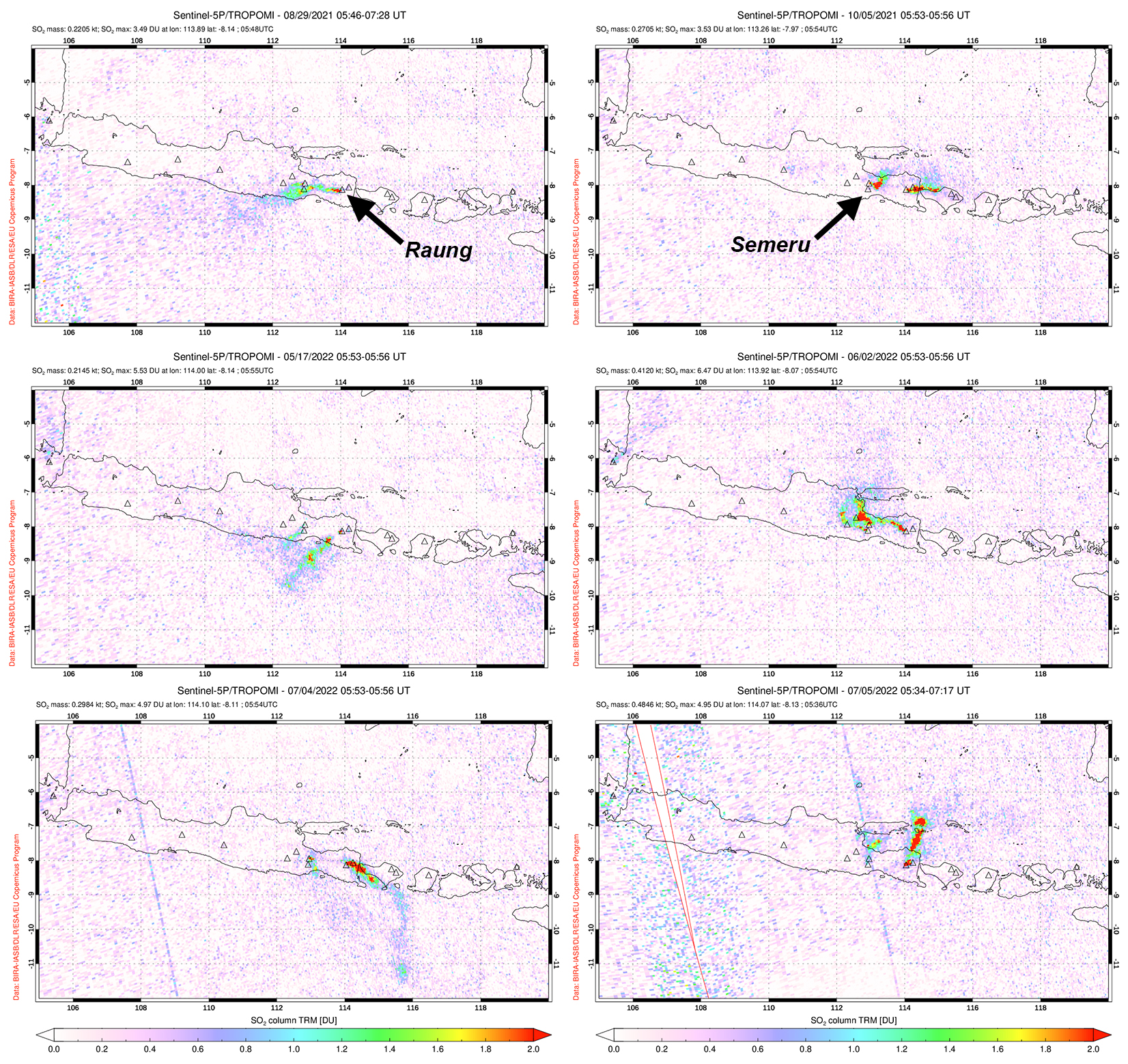 |
Figure 49. Intermittent sulfur dioxide emissions were captured rising from Raung on 29 June 2021 (top left), 5 October 2021 (top right), 17 May 2022 (middle left), and 2 June 2022 (middle right) by the TROPOMI instrument on the Sentinel-5P satellite. Each of the plumes shown here exceed 2 DUs (Dobson Units) and drift in different directions. Stronger defined sulfur dioxide plumes were detected on 4 and 5 July 2022 (bottom left and right, respectively), and drifted SE and NE. Emissions originating further W are from Semeru. Courtesy of NASA Global Sulfur Dioxide Monitoring Page. |
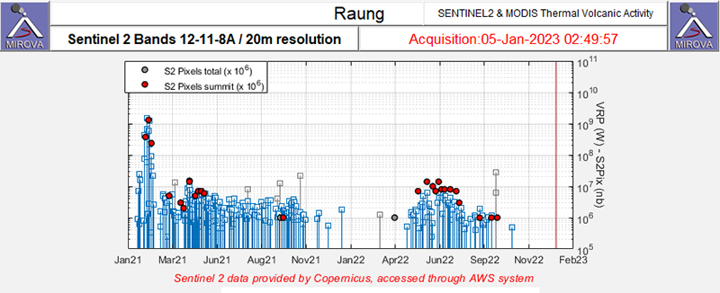 |
Figure 50. Moderate to strong clusters of thermal anomalies (red dots) were detected in the summit area of Raung during early January 2021, March-May 2021, and May-September 2022 as recorded by the Sentinel-2 MODIS Thermal Volcanic Activity data (bands 12, 11, 8A). There was a break in thermal activity were also shown during November 2021-early April 2022. Courtesy of MIROVA. |
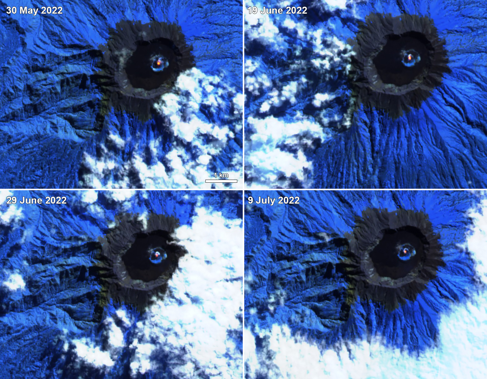 |
Figure 51. Sentinel-2 satellite imagery showed intermittent thermal anomalies in the summit crater of Raung on 30 May 2022 (top left), 19 June 2022 (top right), 29 June 2022 (bottom left), and 9 July 2022 (bottom right). Images use “atmospheric penetration” rendering (bands 12, 11, 8a). Courtesy of Sentinel Hub Playground. |
According to PVMBG, a short-lived eruption occurred at 1719 on 27 July 2022, which produced a gray ash plume that rose 1-1.5 km above the summit and drifted W and NW. A thermal anomaly was observed on 28 July in satellite images, and data from the GPS network indicated inflation. Continuous tremor events were reported during 29 July. As a result of these events, the Volcano Alert Level (VAL) was raised to 2 (on a scale of 1-4) that same day.
Geological Summary. Raung, one of Java's most active volcanoes, is a massive stratovolcano in easternmost Java that was constructed SW of the rim of Ijen caldera. The unvegetated summit is truncated by a dramatic steep-walled, 2-km-wide caldera that has been the site of frequent historical eruptions. A prehistoric collapse of Gunung Gadung on the W flank produced a large debris avalanche that traveled 79 km, reaching nearly to the Indian Ocean. Raung contains several centers constructed along a NE-SW line, with Gunung Suket and Gunung Gadung stratovolcanoes being located to the NE and W, respectively.
Information Contacts: Pusat Vulkanologi dan Mitigasi Bencana Geologi (PVMBG, also known as Indonesian Center for Volcanology and Geological Hazard Mitigation, CVGHM), Jalan Diponegoro 57, Bandung 40122, Indonesia (URL: http://www.vsi.esdm.go.id/); MAGMA Indonesia, Kementerian Energi dan Sumber Daya Mineral (URL: https://magma.esdm.go.id/v1); MIROVA (Middle InfraRed Observation of Volcanic Activity), a collaborative project between the Universities of Turin and Florence (Italy) supported by the Centre for Volcanic Risk of the Italian Civil Protection Department (URL: http://www.mirovaweb.it/); NASA Global Sulfur Dioxide Monitoring Page, Atmospheric Chemistry and Dynamics Laboratory, NASA Goddard Space Flight Center (NASA/GSFC), 8800 Greenbelt Road, Goddard, Maryland, USA (URL: https://so2.gsfc.nasa.gov/); Sentinel Hub Playground (URL: https://www.sentinel-hub.com/explore/sentinel-playground).