Report on Dukono (Indonesia) — October 2022

Bulletin of the Global Volcanism Network, vol. 47, no. 10 (October 2022)
Managing Editor: Edward Venzke.
Research and preparation by Paul Berger.
Dukono (Indonesia) Frequent weak ash explosions and plumes through September 2022
Please cite this report as:
Global Volcanism Program, 2022. Report on Dukono (Indonesia) (Venzke, E., ed.). Bulletin of the Global Volcanism Network, 47:10. Smithsonian Institution.
Dukono
Indonesia
1.6992°N, 127.8783°E; summit elev. 1273 m
All times are local (unless otherwise noted)
Dukono has been erupting continuously since 1933, with frequent ash explosions, ash plumes, and sulfur dioxide plumes (BGVN 46:11). After a period of diminished volcanism during October 2021-March 2022 (BGVN 47:04), activity resumed its more usual heightened pattern through September 2022. The data below were primarily provided by the Pusat Vulkanologi dan Mitigasi Bencana Geologi (PVMBG), also known as the Center for Volcanology and Geological Hazard Mitigation (CVGHM), the Darwin Volcanic Ash Advisory Centre (VAAC), and satellite sensors. Since 15 June 2008, the Alert Level has remained at 2 (on a scale of 1-4) and the public has been warned to remain outside of the 2-km exclusion zone (BGVN 46:11).
According to almost daily images from MAGMA Indonesia (a platform developed by PVMBG), white, gray, or dark plumes were observed almost every day during the reporting period (figure 30). According to the Darwin VAAC, plumes reached an altitude of 2.1-2.7 km (900-1,500 m above the summit) during the last week of May. PVMBG reported that during July-September 2022 plumes often rose 200-1,000 m above the summit.
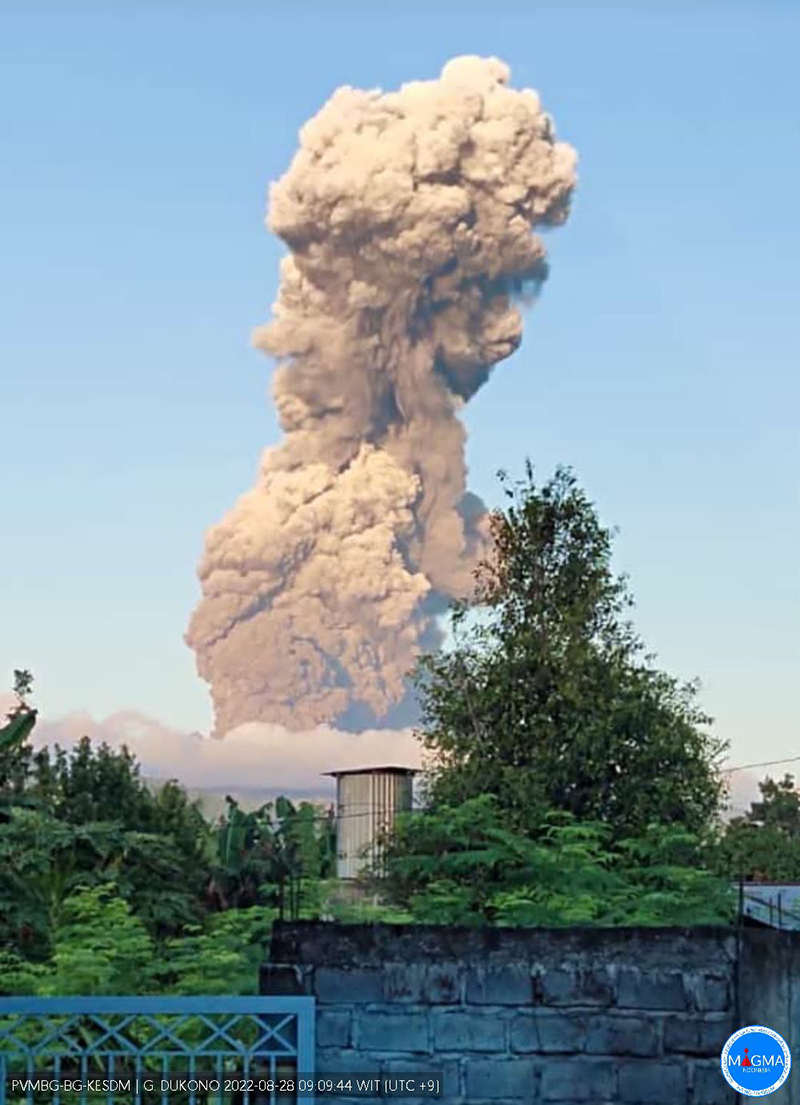 |
Figure 30. Photo of an ash plume rising from Dukono on 28 August 2022. Courtesy of MAGMA Indonesia. |
During the few days when the volcano was not obscured by weather clouds, Sentinel-2 satellite images recorded ash plumes and an occasional thermal anomaly in the summit crater (figure 31). The MIROVA system also recorded a few scattered, low-strength hotspots. Strong sulfur dioxide plumes above the volcano were detected on numerous days every month of the reporting period (figure 32), but their intensity appeared to diminish during August and September 2022.
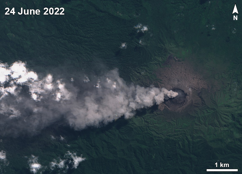 |
Figure 31. Sentinel-2 satellite image of ash plume blowing W from Dukono on 24 June 2022. Sentinel-2 images with natural rendering (bands 4, 3, 2). Courtesy of Sentinel Hub Playground. |
 |
Figure 32. Example of a sulfur dioxide plume from Dukono on 5 May 2022, as detected by the TROPOMI instrument aboard the Sentinel-5P satellite. Courtesy of the NASA Global Sulfur Dioxide Monitoring Page. |
Geological Summary. The Dukono complex in northern Halmahera is on an edifice with a broad, low profile containing multiple peaks and overlapping craters. Almost continuous explosive eruptions, sometimes accompanied by lava flows, have occurred since 1933. During a major eruption in 1550 CE, a lava flow filled in the strait between Halmahera and the Gunung Mamuya cone, 10 km NE. Malupang Wariang, 1 km SW of the summit crater complex, contains a 700 x 570 m crater that has also had reported eruptions.
Information Contacts: Pusat Vulkanologi dan Mitigasi Bencana Geologi (PVMBG, also known as Indonesian Center for Volcanology and Geological Hazard Mitigation, CVGHM), Jalan Diponegoro 57, Bandung 40122, Indonesia (URL: http://www.vsi.esdm.go.id/); MAGMA Indonesia (Multiplatform Application for Geohazard Mitigation and Assessment in Indonesia), Kementerian Energi dan Sumber Daya Mineral (URL: https://magma.esdm.go.id/v1); Darwin Volcanic Ash Advisory Centre (VAAC), Bureau of Meteorology, Northern Territory Regional Office, PO Box 40050, Casuarina, NT 0811, Australia (URL: http://www.bom.gov.au/info/vaac/); NASA Global Sulfur Dioxide Monitoring Page, Atmospheric Chemistry and Dynamics Laboratory, NASA Goddard Space Flight Center (NASA/GSFC), 8800 Greenbelt Road, Goddard, Maryland, USA (URL: https://so2.gsfc.nasa.gov/); Sentinel Hub Playground (URL: https://www.sentinel-hub.com/explore/sentinel-playground); MIROVA (Middle InfraRed Observation of Volcanic Activity), a collaborative project between the Universities of Turin and Florence (Italy) supported by the Centre for Volcanic Risk of the Italian Civil Protection Department (URL: http://www.mirovaweb.it/).