Report on Ibu (Indonesia) — October 2022

Bulletin of the Global Volcanism Network, vol. 47, no. 10 (October 2022)
Managing Editor: Edward Venzke.
Research and preparation by Paul Berger.
Ibu (Indonesia) Eruption continues with almost daily ash plumes through September 2022
Please cite this report as:
Global Volcanism Program, 2022. Report on Ibu (Indonesia) (Venzke, E., ed.). Bulletin of the Global Volcanism Network, 47:10. Smithsonian Institution.
Ibu
Indonesia
1.488°N, 127.63°E; summit elev. 1325 m
All times are local (unless otherwise noted)
Recent activity at Ibu, an Indonesian stratovolcano about 35 km SW of Dukono volcano, has included occasional low-level ash plumes, light ashfall, and thermal anomalies. This report covers similar activity during March-September 2022, using information from the Pusat Vulkanologi dan Mitigasi Bencana Geologi (PVMBG, also known as Indonesian Center for Volcanology and Geological Hazard Mitigation, CVGHM) and various satellite data. The Volcano Alert Level remained at 2 (on a scale of 1-4), and the public was warned to stay at least 2 km away from the active crater and 3.5 km away on the N side.
According to daily reports from MAGMA Indonesia (a platform developed by PVMBG), gray-and-white ash plumes rising 200-1,000 m above the summit were observed almost every day during the reporting period, with a few plumes reaching up to 3 km above the summit (figure 39). Plume heights were variable, though higher plumes were noted during 21-29 April.
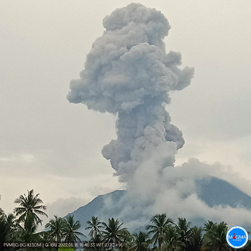 |
Figure 39. Webcam photo of Ibu on 16 May 2022 at 1646 local time showing an ash plume that might have risen as high as 2.5 km above the summit. Photo has been color corrected. Courtesy of MAGMA Indonesia. |
Frequent thermal hotspots were detected by the MIROVA system during the reporting period (figure 40). In contrast, only a few scattered hotspots were identified by the MODIS-MODVOLC thermal alert system, and none in March or June. Satellite imagery continued to show thermal anomalies at both summit craters (figure 41), though the volcano was obscured by weather clouds on all but a few days.
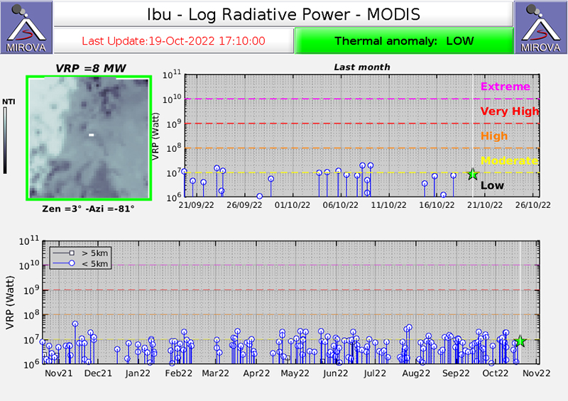 |
Figure 40. The MIROVA (Log Radiative Power) thermal data for Ibu during the year ending in October 2022 showed numerous low-power thermal signals during March-September 2022, except for early April. Courtesy of MIROVA. |
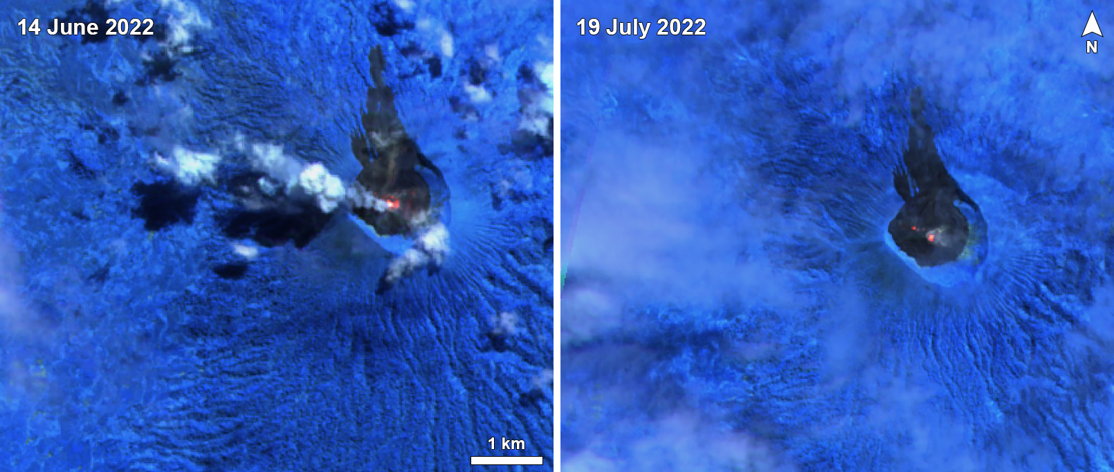 |
Figure 41. Sentinel-2 infrared satellite images of Ibu taken on 14 June (left) and 19 July 2022 (right) showing gray-and-white ash plume drifting W (top) and thermal signals from summit craters. Images taken with Atmospheric penetration rendering (bands 12, 11, 8A). Courtesy of Sentinel Hub Playground. |
Geological Summary. The truncated summit of Gunung Ibu stratovolcano along the NW coast of Halmahera Island has large nested summit craters. The inner crater, 1 km wide and 400 m deep, has contained several small crater lakes. The 1.2-km-wide outer crater is breached on the N, creating a steep-walled valley. A large cone grew ENE of the summit, and a smaller one to the WSW has fed a lava flow down the W flank. A group of maars is located below the N and W flanks. The first observed and recorded eruption was a small explosion from the summit crater in 1911. Eruptive activity began again in December 1998, producing a lava dome that eventually covered much of the floor of the inner summit crater along with ongoing explosive ash emissions.
Information Contacts: Pusat Vulkanologi dan Mitigasi Bencana Geologi (PVMBG, also known as Indonesian Center for Volcanology and Geological Hazard Mitigation, CVGHM), Jalan Diponegoro 57, Bandung 40122, Indonesia (URL: http://www.vsi.esdm.go.id/); MAGMA Indonesia (Multiplatform Application for Geohazard Mitigation and Assessment in Indonesia), Kementerian Energi dan Sumber Daya Mineral (URL: https://magma.esdm.go.id/v1); MIROVA (Middle InfraRed Observation of Volcanic Activity), a collaborative project between the Universities of Turin and Florence (Italy) supported by the Centre for Volcanic Risk of the Italian Civil Protection Department (URL: http://www.mirovaweb.it/); Hawai'i Institute of Geophysics and Planetology (HIGP) - MODVOLC Thermal Alerts System, School of Ocean and Earth Science and Technology (SOEST), Univ. of Hawai'i, 2525 Correa Road, Honolulu, HI 96822, USA (URL: http://modis.higp.hawaii.edu/); Sentinel Hub Playground (URL: https://www.sentinel-hub.com/explore/sentinel-playground).