Report on Krakatau (Indonesia) — November 2022

Bulletin of the Global Volcanism Network, vol. 47, no. 11 (November 2022)
Managing Editor: Benjamin Andrews.
Edited by Kadie L. Bennis.
Krakatau (Indonesia) Explosions, ash plumes, and thermal activity during May-October 2022
Please cite this report as:
Global Volcanism Program, 2022. Report on Krakatau (Indonesia) (Bennis, K.L., and Andrews, B., eds.). Bulletin of the Global Volcanism Network, 47:11. Smithsonian Institution.
Krakatau
Indonesia
6.1009°S, 105.4233°E; summit elev. 285 m
All times are local (unless otherwise noted)
Krakatau volcano in the Sunda Strait between Java and Sumatra, Indonesia, had a major caldera collapse around 535 CE; this event formed a 7-km-wide caldera ringed by the three islands of Verlaten, Lang, and Rakata. A new island grew that was then destroyed in the 1883 caldera-forming eruption. Anak Krakatau (Child of Krakatau), constructed beginning in late 1927 (BGVN 44:03, figure 56), was the site of over 40 smaller eruptions until 22 December 2018 when a large explosion destroyed most of the 338 m above sea level edifice and generated a deadly tsunami (BGVN 44:03). Intermittent ash-bearing explosions from the sea-level crater since May 2021 have contributed to the growth of a new pyroclastic cone to about 150 m elevation. The current eruption period began in May 2021 and has more recently consisted of explosions, gas-and-ash plumes, and thermal activity (BGVN 47:05). This report updates similar activity during May through October 2022 using information provided by the Indonesian Center for Volcanology and Geological Hazard Mitigation, referred to as Pusat Vulkanologi dan Mitigasi Bencana Geologi (PVMBG), MAGMA Indonesia, the Darwin Volcanic Ash Advisory Center (VAAC), and several sources of satellite data.
Activity during May was relatively low and consisted of white gas-and-steam emissions that rose 25-200 m above the summit and drifted in different directions. On 2 May incandescent lava flows in and around the crater that advanced into the sea. According to the Darwin VAAC, continuous gas-and-ash emissions were reported during 5 and 8-20 May rising to 2.4 km altitude and drifting in various directions, based on satellite images and weather models. On 13 May satellite images showed a narrow ash plume that rose to 2.4 km altitude and drifted SE and E. A dense gas-and-steam plume with some amount of ash rose to 2.4 km altitude and drifted NE, N, NW, W, and WNW during 14-16 and 18-19 May.
White gas-and-steam emissions during June rose 25-400 m above the summit and drifted in various directions. According to VONAs (Volcano Observatory Notice for Aviation) from MAGMA Indonesia, eruptive events at 1159, 1305, and 2359 on 8 June generated ash plumes that rose 500 m above the summit and drifted SW and S. Incandescence was visible above the summit during the night of 8 June. A faint plume observed in satellite imagery during 11-12 June that rose to 1.5 km altitude and drifted W, according to Darwin VAAC notices. Ground reporters recorded several eruptive events during 15-17 June that generated dense gray-to-black plumes that rose 300-700 m above the summit and drifted N, SW, W, and S. Webcam images showed that incandescent ejecta accompanied these eruptive events. Eruptive events at 1712 on 25 June and at 0209 on 29 June produced ash plumes that rose 400 m and 2,000 m above the summit and slowly drifted SW and N, respectively. Another event occurred at 1817 on 30 June that generated an ash plume that rose as high as 1 km above the summit and drifted slowly NE.
Similar activity with intermittent eruptive events continued during July; white gas-and-steam emissions rose 25-100 m above the summit and drifted in different directions, though the summit was often obscured by weather clouds. A discrete eruption was observed in satellite imagery, with an ash plume that rose to 900 m altitude and drifted W on 1 July. Nighttime crater incandescence was visible during 2-5 July. Several eruptive events were detected during 16-18 July that rose 1-2.5 km above the summit and drifted NE, S, SW, and W. A webcam image during the night of 16 July showed incandescence at the vent (figure 131). The Darwin VAAC issues noted that during 19-25 July ash plumes rose to 2.6-3 km altitude and drifted in different directions based on satellite and webcam images, as well as weather models.
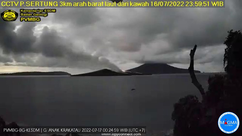 |
Figure 131. Webcam image showing a plume rising above Krakatau accompanied by incandescence on 16 July 2022. Courtesy of MAGMA Indonesia. |
During August and September, cloudy weather often obscured clear views of the summit and activity was relatively low. On clear weather days, white gas-and-steam emissions rose 25-100 m above the summit. Frequent nighttime incandescence was visible at or near the vent (figure 132). MAGMA Indonesia reported several eruptive events during 2-4 August that generated black ash plumes that rose as high as 1.5 km above the summit and drifted NE, SW, and N. During 5-6 August a continuous ash emission was reported rising to 2.4 km altitude and drifted W, though it could not be confirmed in satellite images. Diffuse white gas-and-steam plumes were observed during 7-8 August. A discrete ash emission that rose to 1.2 km altitude and was reported by Darwin VAAC on 24 August.
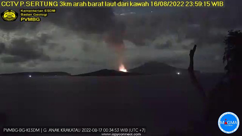 |
Figure 132. Webcam image of an eruptive event at Krakatau during the night on 16 August 2022 showing strong nighttime incandescence. Courtesy of MAGMA Indonesia. |
Low activity continued during October, with white gas-and-steam emissions rising 15-250 m above the summit accompanied by occasional nighttime incandescence. Multiple ash plumes were reported in webcam views and by ground observations during 24-28 October. The ash plumes rose 150-480 m above the summit and drifted NE and E. An eruptive event was recorded at 1845 by the seismic network; a webcam image showed incandescent material ejected above the crater rim. Ash plumes during 26-28 October rose as high as 300 m above the summit and drifted NE.
The MIROVA (Middle InfraRed Observation of Volcanic Activity) graph of MODIS thermal anomaly data showed frequent moderate-to-strong thermal anomalies during May through October (figure 133). Many of those thermal hotspots were detected by the MODVOLC thermal algorithm, with MODVOLC thermal alerts issued on 1 and 8 May, 4, 7, 11, 21, and 27 July, 1, 17, 19, 20, and 28 August, and 4, 12, and 21 September. Sentinel-2 infrared also showed occasional thermal anomalies in the crater accompanied by gas-and-steam plumes that drifted in different directions (figure 134).
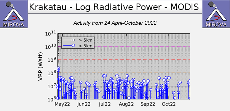 |
Figure 133. Frequent moderate-to-strong thermal anomalies were detected at Anak Krakatau during May through October 2022, based on this MIROVA graph (Log Radiative Power). Courtesy of MIROVA. |
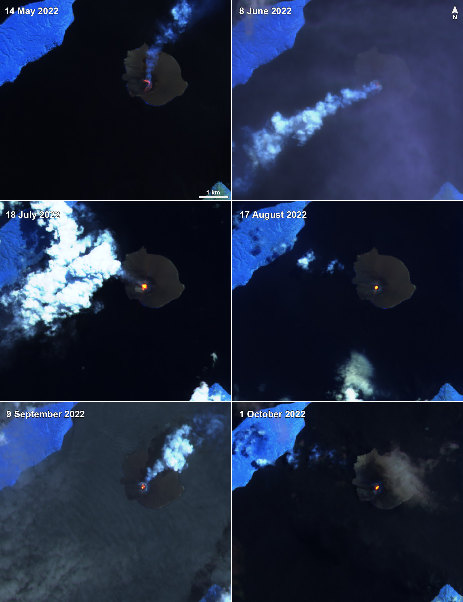 |
Figure 134. A persistent thermal anomaly was detected at Krakatau in Sentinel-2 infrared satellite imagery on clear weather days throughout May-October 2022 . Occasionally, gas-and-steam plumes would accompany this activity and drifted in different directions. Images were captured on 14 May 2022 (top left), 8 June 2022 (top right), 18 July 2022 (middle left), 17 August 2022 (middle right), 9 September 2022 (bottom left), and 1 October 2022 (bottom right). Images with “Atmospheric penetration” (bands 12, 11, 8A) rendering. Courtesy of Sentinel Hub Playground. |
Geological Summary. The renowned Krakatau (frequently mis-named as Krakatoa) volcano lies in the Sunda Strait between Java and Sumatra. Collapse of an older edifice, perhaps in 416 or 535 CE, formed a 7-km-wide caldera. Remnants of that volcano are preserved in Verlaten and Lang Islands; subsequently the Rakata, Danan, and Perbuwatan cones were formed, coalescing to create the pre-1883 Krakatau Island. Caldera collapse during the catastrophic 1883 eruption destroyed Danan and Perbuwatan, and left only a remnant of Rakata. This eruption caused more than 36,000 fatalities, most as a result of tsunamis that swept the adjacent coastlines of Sumatra and Java. Pyroclastic surges traveled 40 km across the Sunda Strait and reached the Sumatra coast. After a quiescence of less than a half century, the post-collapse cone of Anak Krakatau (Child of Krakatau) was constructed within the 1883 caldera at a point between the former Danan and Perbuwatan cones. Anak Krakatau has been the site of frequent eruptions since 1927.
Information Contacts: Pusat Vulkanologi dan Mitigasi Bencana Geologi (PVMBG, also known as Indonesian Center for Volcanology and Geological Hazard Mitigation, CVGHM), Jalan Diponegoro 57, Bandung 40122, Indonesia (URL: http://www.vsi.esdm.go.id/); Darwin Volcanic Ash Advisory Centre (VAAC), Bureau of Meteorology, Northern Territory Regional Office, PO Box 40050, Casuarina, NT 0811, Australia (URL: http://www.bom.gov.au/info/vaac/); MIROVA (Middle InfraRed Observation of Volcanic Activity), a collaborative project between the Universities of Turin and Florence (Italy) supported by the Centre for Volcanic Risk of the Italian Civil Protection Department (URL: http://www.mirovaweb.it/); Hawai'i Institute of Geophysics and Planetology (HIGP) - MODVOLC Thermal Alerts System, School of Ocean and Earth Science and Technology (SOEST), Univ. of Hawai'i, 2525 Correa Road, Honolulu, HI 96822, USA (URL: http://modis.higp.hawaii.edu/); Sentinel Hub Playground (URL: https://www.sentinel-hub.com/explore/sentinel-playground).