Report on Taal (Philippines) — November 2022

Bulletin of the Global Volcanism Network, vol. 47, no. 11 (November 2022)
Managing Editor: Edward Venzke.
Research and preparation by Paul Berger.
Taal (Philippines) Small phreatomagmatic explosions in April and October 2022
Please cite this report as:
Global Volcanism Program, 2022. Report on Taal (Philippines) (Venzke, E., ed.). Bulletin of the Global Volcanism Network, 47:11. Smithsonian Institution.
Taal
Philippines
14.0106°N, 120.9975°E; summit elev. 311 m
All times are local (unless otherwise noted)
Taal is a stratovolcano with a crater lake on a 5-km-wide volcanic island within a large caldera (Lake Taal) in the SW part of Luzon, Philippines, about 65 km S of Manila. Since at least 1968, episodes of increased seismicity, elevated lake temperatures, steaming, significant sulfur dioxide plumes, and deformation have been reported, both during and independent of eruptive periods. A series of phreatic and phreatomagmatic explosions began in January 2020, and subsequent explosions occurred in July and November 2021, and January-March 2022 (NSEB 02:10, SEAN 03:02, BGVN 45:06, 46:10, 47:04). This report describes activity during April-October 2022 using reports from the Philippine Institute of Volcanology and Seismology (PHIVOLCS), the Tokyo Volcanic Ash Advisory Center (VAAC), and satellite data.
PHIVOLCS reported that hot volcanic fluids circulated and upwelled in Taal’s crater lake during 30 March through 6 April 2022, producing plumes that rose as high as 2 km above the lake’s surface and drifted SW. Tremor persisted daily until 5 April. Three phreatomagmatic bursts from the Main Crater were detected at 1039, 1047, and 1055 on 1 April, based on seismic data and webcam images, which produced plumes 500-900 m above the lake that drifted SW.
The Alert Level for Taal was lowered to 2 (on a scale of 0-5) by PHIVOLCS on 9 April 2022, noting a significant decrease in activity during the previous two weeks. Sulfur dioxide emissions that had peaked at 21,211 metric tons per day (t/d) on 16 March, dropped significantly during the first half of April and on 11 April were below detection limits; this was the lowest number recorded since unrest began in 2021. Diffuse plumes from the lake had also decreased in frequency, though they rose 600-900 m above the surface during 10-12 April. On 11 July PHIVOLCS lowered the Alert Level to 1, noting that during the previous two months activity had returned to baseline levels of volcanic earthquakes, weak gas emissions, and minor surface activity.
In May and June 2022, sulfur dioxide emissions increased, then increased more beginning on 15 July. Another significant increase was measured during early August, peaking on 7 August (table 1). Vog, dense in some locations, was present over the W part of the caldera during 2-3 August and caused vegetation damage. Upwelling gas and hot fluids in the lake, and voluminous steam-rich plumes rising as high as 3 km above the lake, were visible during 1-15 August. Low-frequency earthquakes and tremor increased above background levels. Strong sulfur dioxide plumes were detected during the last third of April; none were detected in May or June, a few were scattered in July, about half the days consisted of plumes in August, and intermittent plumes occurred during September and October (figure 29).
Table 1. Sulfur dioxide levels measured at Taal during 15 July through October 2022. Compiled from PHIVOLCS reports.
| Date | Average Value (metric tons/day) | Remarks |
| 15 Jul-03 Aug 2022 | 4,952 | High of 12,125 t/d on 3 August; vog over the W part of Taal Caldera during 2-3 August; dense vog in Laurel (11 km NW) and Banyaga (6 km W) damaged vegetation. Sulfur odor reported by residents of Tagaytay City (12 km NNW) and Bugaan East (7 km NW). |
| 7 Aug | 17,141 | PHIVOLCS issued advisory |
| 9-15 Aug 2022 | 3,802-6,844 | High of 13,572 t/d on 11 August; significant vog around the caldera and a sulfur odor reported by residents of Banyaga, Poblacion (9 km NNE), Boso-boso (5 km WNW), and Gulod (7 km WNW), and Poblacion. |
| Sep 2022 | 6,612 | High of 10,718 t/d on 29 Sep; significant vog over caldera. Vog reported by residents of Laurel, Agoncillo (8 km WSW), and Santa Teresita (15 km SSW) |
| Oct 2022 | 3,882 | Measured 3,882 t/d on 13 Oct; 4,422 on 17 Oct; 6,702 on 20 Oct; 1,403 on 24 Oct; 544 on 27 Oct. |
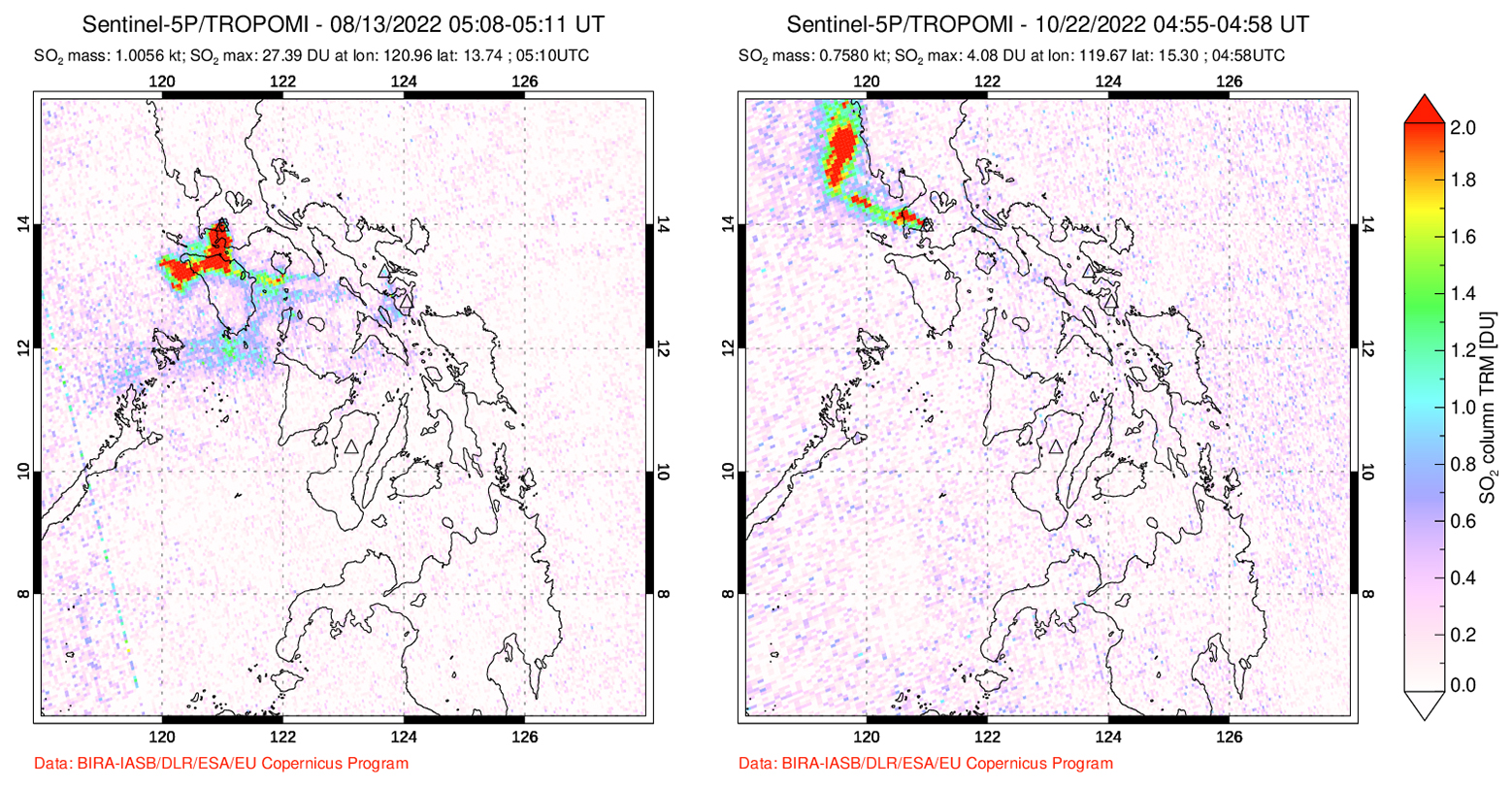 |
Figure 29. Typical examples of strong sulfur dioxide plumes from Taal, shown here on 13 August and 22 October 2022, as detected by the TROPOMI instrument aboard the Sentinel-5P satellite. Courtesy of the NASA Global Sulfur Dioxide Monitoring Page. |
PHIVOLCS reported increased unrest during 5-29 October, with a series of phreatomagmatic explosions (table 2). The explosions were accompanied by volcanic earthquakes and tremor. In addition to phreatomagmatic explosions, upwellings of gas and hot fluid in the lake were typically visible in October, with white steam emissions rising 600-3,000 m above the lake.
Table 2. Phreatomagmatic explosions at Taal recorded during October 2022. The lake is about 300 m above sea level. Data courtesy of PHIVOLCS and the Tokyo VAAC.
| Date | Description |
| 05 Oct 2022 | 3-minute-long burst; according to Tokyo VAAC, an ash plume rose to 600 m altitude and drifted SW. |
| 14-15 Oct 2022 | Six small explosions, each lasting 1-2 minutes; Tokyo VAAC reported that three ash plumes rose as high as 600 m altitude and drifted NW. |
| 15-16 Oct 2022 | One explosion. |
| 21-22 Oct 2022 | Webcam recorded 29 bursts from vent on NE part of lake, each lasting 1-5 minutes long. Some events produced 200-m-high steam-rich plumes and very, short, dark ash plumes that immediately collapsed back into the water. Not all events generated detectable signals in the seismic and infrasound records. According to the Tokyo VAC, ash plumes rose to 600 m altitude on 21 October and drifted W. |
| 22-23 Oct 2022 | Two bursts, each lasting 6-7 minutes long. |
| 25-29 Oct 2022 | Range of 2-16 daily bursts. Tokyo VAAC noted that three ash plumes rose as high as 600 m altitude and drifted NW and SW during 26-28 October. |
Thermal measurements made by MODIS satellite instruments and processed by MIROVA showed numerous hotspots throughout the reporting period (figure 30). The MODVOLC thermal alerts system recorded only occasional hotspots during the reporting period. The number of days with hotspots during April-October 2022 ranged from 2 to 6 (April: 6, May: 3, June: 4, July: 5, August: 3, September: 5, October: 2). During the series of phreatomagmatic explosions in October, only two hotspots were recorded by MODVOLC.
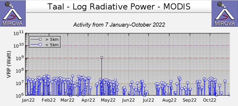 |
Figure 30. Log Radiative Power graph of thermal anomalies at Taal during 2022, as recorded by the MIROVA system, showing numerous low to moderate power hotspots during April-October 2022. Courtesy of MIROVA. |
Geological Summary. Taal is one of the most active volcanoes in the Philippines and has produced some powerful eruptions. The 15 x 20 km Talisay (Taal) caldera is largely filled by Lake Taal, whose 267 km2 surface lies only 3 m above sea level. The maximum depth of the lake is 160 m, with several submerged eruptive centers. The 5-km-wide Volcano Island in north-central Lake Taal is the location of all observed eruptions. The island is composed of coalescing small stratovolcanoes, tuff rings, and scoria cones. Powerful pyroclastic flows and surges have caused many fatalities.
Information Contacts: Philippine Institute of Volcanology and Seismology (PHIVOLCS), Department of Science and Technology, University of the Philippines Campus, Diliman, Quezon City, Philippines (URL: http://www.phivolcs.dost.gov.ph/); Tokyo Volcanic Ash Advisory Center (VAAC), 1-3-4 Otemachi, Chiyoda-ku, Tokyo 100-8122, Japan (URL: http://ds.data.jma.go.jp/svd/vaac/data/); MIROVA (Middle InfraRed Observation of Volcanic Activity), a collaborative project between the Universities of Turin and Florence (Italy) supported by the Centre for Volcanic Risk of the Italian Civil Protection Department (URL: http://www.mirovaweb.it/); Hawai'i Institute of Geophysics and Planetology (HIGP) - MODVOLC Thermal Alerts System, School of Ocean and Earth Science and Technology (SOEST), Univ. of Hawai'i, 2525 Correa Road, Honolulu, HI 96822, USA (URL: http://modis.higp.hawaii.edu/); NASA Global Sulfur Dioxide Monitoring Page, Atmospheric Chemistry and Dynamics Laboratory, NASA Goddard Space Flight Center (NASA/GSFC), 8800 Greenbelt Road, Goddard, Maryland, USA (URL: https://so2.gsfc.nasa.gov/); Sentinel Hub Playground (URL: https://www.sentinel-hub.com/explore/sentinel-playground).