Report on Bezymianny (Russia) — November 2022
Bulletin of the Global Volcanism Network, vol. 47, no. 11 (November 2022)
Managing Editor: Edward Venzke.
Edited by Kadie L. Bennis.
Bezymianny (Russia) Strong explosions in late May and late October 2022, accompanied by ash plumes and thermal activity
Please cite this report as:
Global Volcanism Program, 2022. Report on Bezymianny (Russia) (Bennis, K.L., and Venzke, E., eds.). Bulletin of the Global Volcanism Network, 47:11. Smithsonian Institution.
Bezymianny
Russia
55.972°N, 160.595°E; summit elev. 2882 m
All times are local (unless otherwise noted)
Bezymianny, located on the Kamchatka Peninsula of Russia as part of the Klyuchevskoy volcano group, has had eruptions that date back to 1955 characterized by dome growth, explosions, pyroclastic flows, ash plumes, and ashfall. During the 1955-56 eruption a large open crater was formed by collapse of the summit and an associated lateral blast. Subsequent episodic but ongoing lava-dome growth, accompanied by intermittent explosive activity and pyroclastic flows, has largely filled the 1956 crater. The current eruption period began in December 2016 and more recent activity has consisted of a strong explosion with ash plumes during mid-March 2022. Gas-and-steam emissions and frequent thermal anomalies at the summit crater were also reported. This report updates information during May through October 2022 of similar activity, based on weekly and daily reports from the Kamchatka Volcano Eruptions Response Team (KVERT), Tokyo VAAC (Volcanic Ash Advisory Center), and satellite data.
Activity during May was relatively strong, with explosions, strong fumarolic activity, hot avalanches, and frequent thermal anomalies at the lava dome that were detected in satellite imagery. On 24 May gas-and-steam plumes containing some amount of ash rose to 3-4.5 km altitude and drifted 30 km NW. Similar activity occurred on 25 May when plumes drifted 25 km NE and 30 km W. During 23-28 May seismicity increased, according to KVERT. Multiple notable collapses of hot avalanches on the E flank produced ash plumes that rose to 4-5 km altitude and drifted 70-320 km in different directions.
Activity significantly increased on 28 May. According to Kamchatka Volcanological Station (Volkstat), observers saw ash plumes beginning to rise around lunchtime, with the plumes gradually increasing in altitude throughout the day. During the late evening a large, strong, explosive event occurred; ash plumes rose to 11 km altitude and drifted E. According to KVERT satellite data showed ash plumes rising to 10-12 km altitude and drifting ESE at 1920. As a result, the Aviation Color Code (ACC) was raised to Red (the highest level on a four-color scale). By 2010 the ash plumes had risen to 15 km altitude and previous ash emissions had drifted 365 km SE. Volkstat observers noted that activity began to decline by about 2020; plumes did not exceed 6 km altitude and drifted SE. At 2207 KVERT issued a VONA (Volcano Observatory Notice for Aviation) that reported that the ACC was lowered to Orange because the most intense phase of the explosive eruption had ended. Ash plumes continued to rise no higher than 5 km, based on webcam images. Two ash plumes were identified in satellite images; the first drifted 212 km SE at an altitude of 9.5 km altitude and the second drifted 650 km SE, though the altitude was unspecified. On 29 May at 1000 gas-and-steam plumes containing some ash, visible in webcam images, rose as high as 4.5 km altitude and drifted 45 km SE. Satellite images showed that the large ash plume from 28 May had drifted 1,635-3,500 km SE throughout the day. In Washington and Tokyo VAAC notices on 30 May a remnant ash plume had risen to 4.9-15.2 km altitude and was visible in satellite imagery over the north Pacific.
During June and July strong fumarolic activity persisted, a thermal anomaly was often detected in satellite imagery through the early part of July, and lava dome incandescence and hot avalanches were frequently reported (figure 49). On 3 July the Tokyo VAAC reported a possible ash plume rose to 6.4 km altitude and extended SE, though meteoric clouds obscured views of the summit. Similar low activity continued during August; strong fumarolic activity continued with lava dome incandescence and hot avalanches. A thermal anomaly was frequently reported throughout the month. The Tokyo VAAC reported that on 22 August an ash plume was identified in satellite imagery rose to 3.7 km altitude and drifted NE.
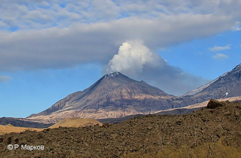 |
Figure 49. Photo of a strong white gas-and-steam plume rising above Bezymianny on 7 June 2022. An active lava flow was reported at the lava dome on the E flank. Courtesy of R. Markov, KVERT. |
Low activity continued through September and during much of October, which typically consisted of a thermal anomaly on clear weather days and gas-and-steam emissions. Activity increased during 22-23 October and was characterized by summit crater incandescence, occasional strong fumarolic activity, and an increasing temperature of a thermal anomaly that was detected in satellite images. A strong explosive event began on 23 October at 2340, with satellite images showing ash plumes rising to 10 km altitude and drifting 10 km ENE (figure 50). By the next day the ash plumes had drifted as far as 1,915 km NE. On 26 October avalanches generated an ash cloud that rose to 6 km and drifted 70 km E.
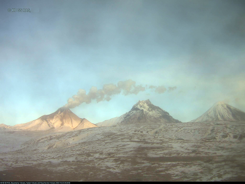 |
Figure 50. Webcam image of a gray ash plume rising from Bezymianny on 23 October 2023 and drifting ENE due to a strong explosion. Photo has been color corrected. Courtesy of Yu Demyanchuk, KVERT. |
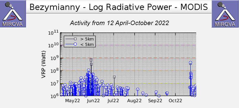
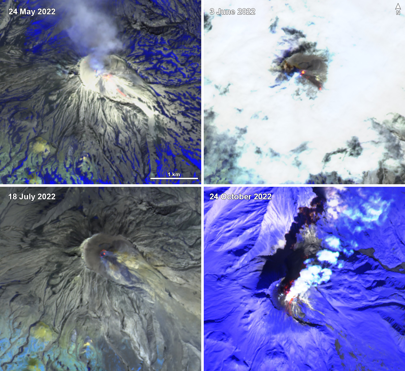
Strong thermal activity occurred frequently during May, June, and October, based on satellite data. A total of 11 thermal hotspots were detected by the MODVOLC thermal algorithm on 15, 20, 23, 25, and 30 May, 2 June, and 23 October. These days of stronger thermal activity were also reflected in other satellite data sources and occurred around days when a strong explosive event took place, according to KVERT. The MIROVA (Middle InfraRed Observation of Volcanic Activity) volcano hotspot detection system based on the analysis of MODIS data showed a gradual increase in both frequency and power during May, which both peaked during late May (figure 51). During June through mid-July the anomalies gradually decreased in both frequency and power. By August only three anomalies were detected by the MIROVA system, and in September four anomalies were detected. During late October, there was another increase in power and frequency, followed by several lower-power anomalies. Sentinel-2 infrared satellite imagery captured incandescence at the summit crater on clear weather days during these periods of stronger thermal activity (figure 52). On 24 May an incandescent avalanche was also visible on the SE flank. On 3 June a second thermal anomaly was detected on the SE flank as well. On 24 October several small thermal anomalies were visible in the summit crater and on the S flank.
Geological Summary. The modern Bezymianny, much smaller than its massive neighbors Kamen and Kliuchevskoi on the Kamchatka Peninsula, was formed about 4,700 years ago over a late-Pleistocene lava-dome complex and an edifice built about 11,000-7,000 years ago. Three periods of intensified activity have occurred during the past 3,000 years. The latest period, which was preceded by a 1,000-year quiescence, began with the dramatic 1955-56 eruption. This eruption, similar to that of St. Helens in 1980, produced a large open crater that was formed by collapse of the summit and an associated lateral blast. Subsequent episodic but ongoing lava-dome growth, accompanied by intermittent explosive activity and pyroclastic flows, has largely filled the 1956 crater.
Information Contacts: Kamchatka Volcanic Eruptions Response Team (KVERT), Far Eastern Branch, Russian Academy of Sciences, 9 Piip Blvd., Petropavlovsk-Kamchatsky, 683006, Russia (URL: http://www.kscnet.ru/ivs/kvert/); Kamchatka Volcanological Station, Kamchatka Branch of Geophysical Survey, (KB GS RAS), Klyuchi, Kamchatka Krai, Russia (URL: http://volkstat.ru/); Tokyo Volcanic Ash Advisory Center (VAAC), 1-3-4 Otemachi, Chiyoda-ku, Tokyo 100-8122, Japan (URL: http://ds.data.jma.go.jp/svd/vaac/data/); Washington Volcanic Ash Advisory Center (VAAC), Satellite Analysis Branch (SAB), NOAA/NESDIS OSPO, NOAA Science Center Room 401, 5200 Auth Rd, Camp Springs, MD 20746, USA (URL: www.ospo.noaa.gov/Products/atmosphere/vaac, archive at: http://www.ssd.noaa.gov/VAAC/archive.html); MIROVA (Middle InfraRed Observation of Volcanic Activity), a collaborative project between the Universities of Turin and Florence (Italy) supported by the Centre for Volcanic Risk of the Italian Civil Protection Department (URL: http://www.mirovaweb.it/); Hawai'i Institute of Geophysics and Planetology (HIGP) - MODVOLC Thermal Alerts System, School of Ocean and Earth Science and Technology (SOEST), Univ. of Hawai'i, 2525 Correa Road, Honolulu, HI 96822, USA (URL: http://modis.higp.hawaii.edu/); Sentinel Hub Playground (URL: https://www.sentinel-hub.com/explore/sentinel-playground).

