Report on Great Sitkin (United States) — November 2022
Bulletin of the Global Volcanism Network, vol. 47, no. 11 (November 2022)
Managing Editor: Edward Venzke.
Research and preparation by Paul Berger.
Great Sitkin (United States) Slow lava effusion continued during May-October 2022
Please cite this report as:
Global Volcanism Program, 2022. Report on Great Sitkin (United States) (Venzke, E., ed.). Bulletin of the Global Volcanism Network, 47:11. Smithsonian Institution.
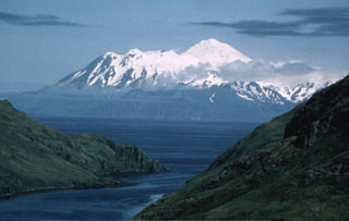
Great Sitkin
United States
52.076°N, 176.13°W; summit elev. 1740 m
All times are local (unless otherwise noted)
After an ash explosion in 1974, the only confirmed volcanic activity at Great Sitkin through 2019 included small phreatic eruptions in June and August 2018 and June 2019, and an ash explosion on 25 May 2019 (BGVN 43:09, 44:07, 46:08). During mid-July 2021 a lava dome began to grow in the summit crater and effuse lava, which soon overtopped the summit crater wall and flowed down the N, S, and W flanks (BGVN 46:08, 47:05). This activity waned during January-April 2022, although slow lava effusion continued. The current report updates activity during May-October 2022. Great Sitkin, located in Alaska’s Aleutian Island chain, is monitored by the Alaska Volcano Observatory (AVO) using local seismic and infrasound sensors, satellite data, web cameras, and remote infrasound and lightning networks.
AVO reported that the slow lava effusion from a vent in the summit crater likely continued during May-October 2022 (figure 21). Satellite images showed that the flank flow had advanced 15 m S by the first week of May, and 15 m E by 1 July. During July through the first part of September the lava flow thickened around the vent in the summit crater, but did not advance. At the beginning of September the lava flow continued to thicken but also began to expand slowly within the summit crater, but not on the flanks; this slow expansion continued through October to the S and E. Consistent with the lava effusion, satellite data indicated that surface temperatures were elevated. During the reporting period, steam emissions were occasionally visible.
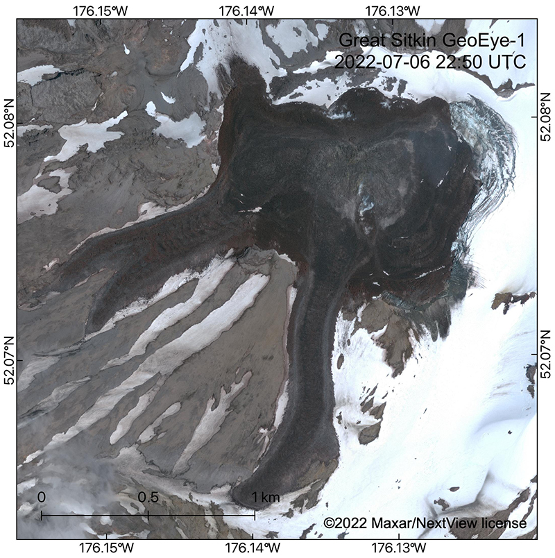 |
Figure 21. GeoEye-1 satellite image showing the lava flow field in Great Sitkin’s summit crater and upper flanks on 6 July 2022. The image shows that the slow lava effusion has flowed to the NE into the summit glacier, which is collapsing (see concentric curved crevasses) from melting due to lava interaction. Courtesy of Hannah Dietterich, AVO. |
Sentinel-2 infrared images confirmed that lava effusion continued through September 2022, with either one or two distinct hotspots (figure 22). Weather clouds obscured satellite observations on most viewing days. The MIROVA (Middle InfraRed Observation of Volcanic Activity) volcano hotspot detection system recorded seven brief discrete pulses of 4-7 hotspots each in the summit crater during May-October 2022 (figure 23).
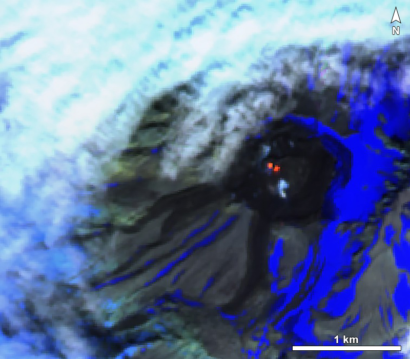 |
Figure 22. Sentinel-2 image of Great Sitkin showing two hotspots within the summit crater on 21 August 2022. Images taken with “Atmospheric penetration” rendering (bands 12, 11, 8A). Courtesy of Sentinel Hub Playground. |
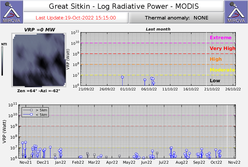 |
Figure 23. Thermal anomalies at Great Sitkin during the year ending 19 October 2022, seen on a MIROVA graph of log radiative power. A pattern of brief pulses of thermal anomalies are evident during May-October 2022. Courtesy of MIROVA. |
Seismic activity remained at low levels throughout; occasional local earthquakes were recorded. The Volcano Alert Level remained at Watch (the second highest level on a four-level scale) and the Aviation Color Code remained at Orange (the second highest level on a four-color scale).
Geological Summary. The Great Sitkin volcano forms much of the northern side of Great Sitkin Island. A younger volcano capped by a small, 0.8 x 1.2 km ice-filled summit caldera was constructed within a large late-Pleistocene or early Holocene scarp formed by massive edifice failure that truncated an older edifice and produced a submarine debris avalanche. Deposits from this and an even older debris avalanche from a source to the south cover a broad area of the ocean floor north of the volcano. The summit lies along the eastern rim of the younger collapse scarp. Deposits from an earlier caldera-forming eruption of unknown age cover the flanks of the island to a depth up to 6 m. The small younger caldera was partially filled by lava domes emplaced in 1945 and 1974, and five small older flank lava domes, two of which lie on the coastline, were constructed along northwest- and NNW-trending lines. Hot springs, mud pots, and fumaroles occur near the head of Big Fox Creek, south of the volcano. Eruptions have been recorded since the late-19th century.
Information Contacts: Alaska Volcano Observatory (AVO), a cooperative program of a) U.S. Geological Survey, 4200 University Drive, Anchorage, AK 99508-4667 USA (URL: https://avo.alaska.edu/), b) Geophysical Institute, University of Alaska, PO Box 757320, Fairbanks, AK 99775-7320, USA, and c) Alaska Division of Geological & Geophysical Surveys, 794 University Ave., Suite 200, Fairbanks, AK 99709, USA (URL: http://dggs.alaska.gov/); Sentinel Hub Playground (URL: https://www.sentinel-hub.com/explore/sentinel-playground); MIROVA (Middle InfraRed Observation of Volcanic Activity), a collaborative project between the Universities of Turin and Florence (Italy) supported by the Centre for Volcanic Risk of the Italian Civil Protection Department (URL: http://www.mirovaweb.it/).