Report on Piton de la Fournaise (France) — December 2022

Bulletin of the Global Volcanism Network, vol. 47, no. 12 (December 2022)
Managing Editor: Benjamin Andrews.
Edited by Kadie L. Bennis.
Piton de la Fournaise (France) New eruption with lava fountains, flows, and gas-and-steam emissions during September-October 2022
Please cite this report as:
Global Volcanism Program, 2022. Report on Piton de la Fournaise (France) (Bennis, K.L., and Andrews, B., eds.). Bulletin of the Global Volcanism Network, 47:12. Smithsonian Institution.
Piton de la Fournaise
France
21.244°S, 55.708°E; summit elev. 2632 m
All times are local (unless otherwise noted)
Piton de la Fournaise is a massive basaltic shield volcano on the French island of Réunion in the western Indian Ocean. Most recorded eruptions have originated from the summit and flanks of Dolomieu, a 400-m-high lava shield that grew within the youngest scarp, which is about 9 km wide and extends about 13 km from the W wall to the ocean on the E side. More than 150 eruptions, a majority of which have consisted of basaltic lava flows, were recorded since the 17th century. The most recent eruption ended in January 2022, which was characterized by lava fountains and flows on the S flank (BGVN 47:04). This report describes a new eruption with lava fountains, flows, and strong sulfur dioxide emissions during September through October 2022 using information from the Observatoire Volcanologique du Piton de la Fournaise (OVPF) and satellite data.
Activity during September consisted of 1,191 volcano-tectonic earthquakes under the summit crater and 55 long-period earthquakes; two notable seismic crises were reported on 7 and 19 September. The first seismic crisis began at 1654 on 7 September and lasted just under three hours. During this time, 268 volcano-tectonic earthquakes were recorded under the N rim of the Dolomieu crater.
The second seismic crisis was detected at 0623 on 19 September on the SSW flank of the caldera (figure 223). 375 volcano-tectonic earthquakes were recorded, accompanied by rapid deformation. No initial visual confirmation was made in webcam images due to bad weather conditions. After the initial pulse, there was a marked drop in amplitude tremor at the start of the eruption, which is typical for this volcano. OVPF reported that the eruption began around 0748; three fissures opened on the S flank inside the Enclos Fouqué caldera at the base of Piton Kala Pélé. Soon after, activity focused at a single area at 2.2 km elevation and a new cone began to form. There were 72 volcano-tectonic earthquakes detected, many of which occurred under the S rim of the Dolomieu crater. Pelotons de Gendarmerie de Haute Montagne (PGHM) teams that were onsite to evacuate people from inside the caldera observed that lava fountaining began to the E of Piton Kala Pélé from a newly opened fissure and rose 20-30 m high (figure 224). TROPOMI satellite data showed that the volume of sulfur dioxide emissions was 2,000 t/d during the start of the eruption until 1410 on 19 September and drifted SW (figure 225). By 20 September, the OVPF-IPGP NOVAC station located on the W side detected sulfur dioxide gases that peaked in volume of 8,000 tons/day (t/d). This volume was similar to or slightly higher than measurements taken during the previous eruption from 22 December 2021-17 January 2022, according to OVPF.
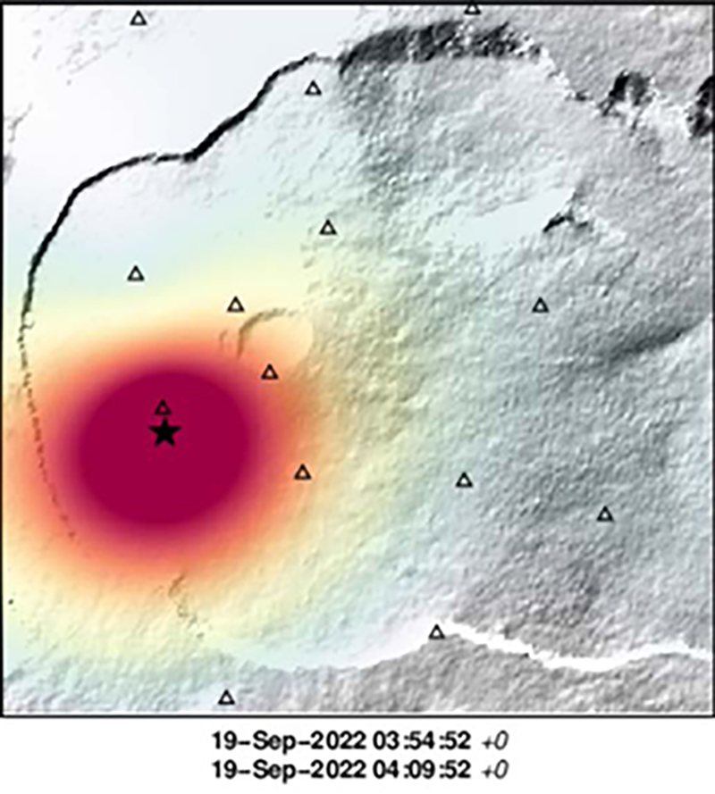 |
Figure 223. Location map of the seismic swarm (most concentrated in the red circle) that occurred at Piton de la Fournaise (star) during 0354 and 0409 on 19 September 2022 at the base of the SSW cone in the Rivals crater. Courtesy of OVPF-IPGP. |
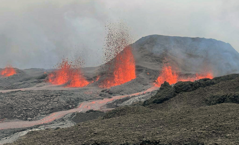 |
Figure 224. Photo of lava fountains and lava flows at Piton de la Fournaise during the early afternoon of 19 September 2022. The lava fountains rose as high as 30 m. Photo has been color corrected. Courtesy of OVPF-IPGP. |
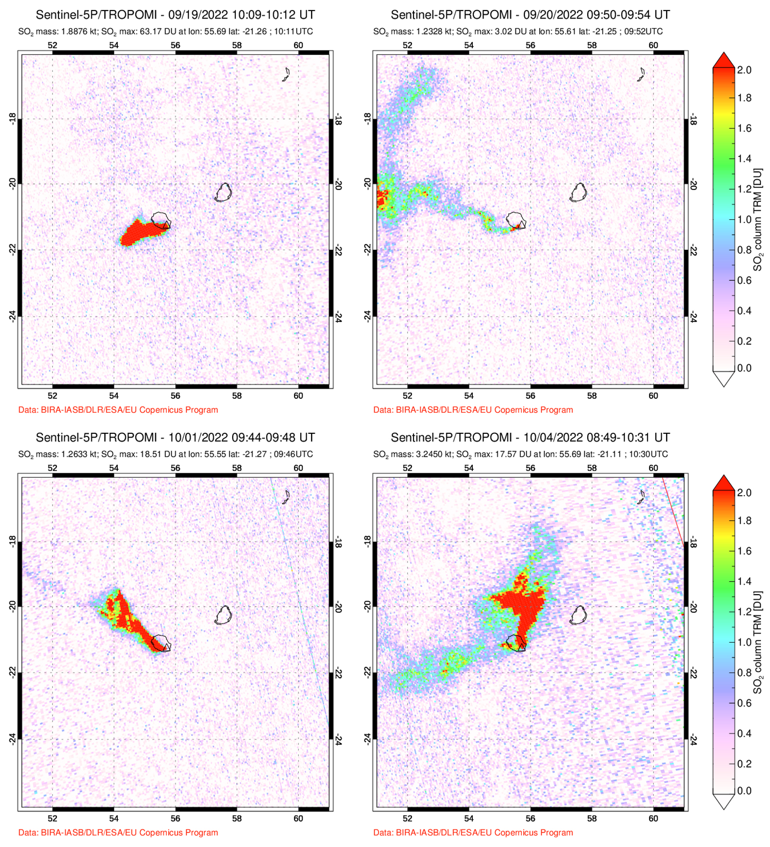 |
Figure 225. Strong sulfur dioxide plumes were captured in Sentinel-5P satellite images using TROPOMI data at Piton de la Fournaise on 19 September 2022 (top left), 20 September 2022 (top right), 1 October 2022 (bottom left), and 4 October 2022 (bottom right), which accompanied new eruptive activity. The plumes drifted W, NW, and N and exceeded 2 Dobson Units (DU). Courtesy of NASA Global Sulfur Dioxide Monitoring Page. |
After 19 September both the lava fountain activity and eruptive tremor decreased. Lava flow estimates could not be made due to weather clouds obscuring satellite views. On 20 September 24 volcano-tectonic events were detected. The volume of sulfur dioxide emissions measured on 20 September was 2,300 t/d. On 21 September the weather improved slightly and allowed a team to observe the eruption with the Gendarmerie Air Force and PGHM. OVPF-IPGP webcam images showed a marked decrease in lava fountaining and flow activity at the lowest part of the fissure on 21 September (figure 226). Lava flow estimates were determined using satellite data from the HOTVOLC system (University of Clermont-Auvergne) during the afternoon; the effusion rate peaked at 2.5 m3/s and during the morning of 22 September shorter flows peaked at 3.6 m3/s. Eruptive tremor began to gradually increase again on 22 September after three days of decrease but remained relatively low compared to the initial spike on 19 September (figure 227). The volume of sulfur dioxide emissions decreased during 21-24 September to less than 1,000 t/d.
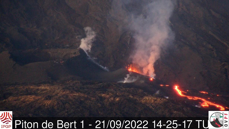 |
Figure 226. Webcam image showing the eruptive fissure site of Piton de la Fournaise at 1106 (local time) on 21 September 2022. Gas-and-steam emissions accompanied lava effusions and fountaining. The fountaining activity was notably lower compared to the initial activity on 19 September. Courtesy of OVPF-IPGP. |
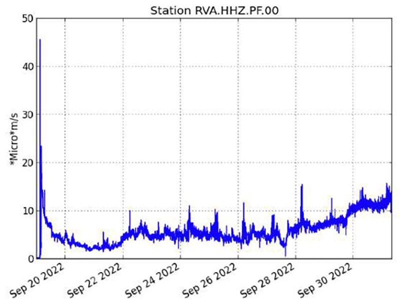 |
Figure 227. Graph showing the spike and then immediate decrease in eruptive tremor in RSAM (Real-time Seismic Amplitude Measure) values at Piton de la Fournaise during 19 September 2022 through 30 September 2022, using data from a seismic station located near the Rivals crater. A gradual increase in eruptive tremor began on 22 September, which then continued to slightly increase through the end of the month. Courtesy of OVPF. |
The average flow rate was 1.5 m3/s during 22-24 September, and during 23 September the HOTVOLC system recorded a relatively stable flow rate of about 4 m3/s. Lava flow estimates indicated a minimum emitted volume of about 1.2-2.5 million m3 during 19-24 September. By 24 September lava flow activity mainly took place through lava tubes and traveled in the SE and ESE directions (figure 228). The activity lava flow front was located at the Château Fort section of the crater at 2 km elevation on 24 September, though this flow stopped advancing by 26 September.
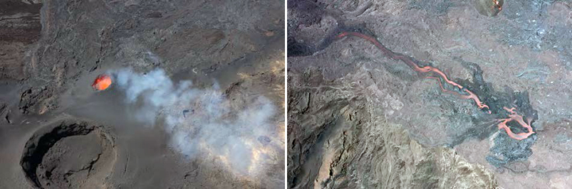 |
Figure 228. Aerial photos showing the active lava fountains within the main eruptive vent (left) and lava effusions toward the SE direction (right) at Piton de la Fournaise around 1100 (local time) on 24 September 2022. White gas-and-steam emissions often accompanied the lava fountaining activity. Courtesy of OVPF-IPGP. |
Lava flow estimates based on the HOTVOLC and MIROVA systems indicated that the average lava flow rate during 26-29 September was 2-4 m3/s and peaked at 8 m3/s on 26 September. Images from the Piton de Bert webcam showed that significant degassing and low-amplitude tremor continued. A gas-and-steam plume drifted SW based on satellite images on 26 September. Observations made on 26 September reported that the primary eruptive vent was characterized by lava fountaining and had formed a cone (figure 229). The most active lava flow extended ESE toward the Château Fort crater. The active lava flow that spread to the ESE and SE traveled as far as 3 km. Weak gas-and-steam emissions drifted as far as 200 km W and the mass was estimated to be about 200-2,000 t/d on 27 September.
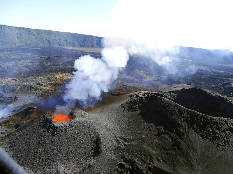 |
Figure 229. Photo of a well-formed cone around the active vent and lava fountaining activity at Piton de la Fournaise on 26 September 2022. White gas-and-steam plumes also persisted at this vent. Courtesy of OVPF-IPGP. |
By 28 September lava at the eruptive vent began to cool and showed corded lava flows (figure 230). Field observations made on 28 September showed that a second vent had opened on the S flank of the main eruptive cone around 1115 (figure 231). The amplitude of the eruptive tremor began to increase around 2140 on 29 September, which OVPF reported was likely due to an increase in pressure within the main eruptive cone that had widened since the beginning of the eruption. Additionally, there was an increase in activity at the secondary cone. Stereophotogrammetry showed that the side of the main eruptive cone was about 27 m high and 87 m wide. Throughout the day on 30 September activity at the secondary vent gradually subsided. Based on a TROPOMI satellite image, a dense sulfur dioxide plume with a mass of 800-5,800 t/d was detected drifting as far as 300 km NW. According to measurements made on 30 September, the volume of effused lava at the surface during 19-30 September ranged between 2.6-5.4 million m3.
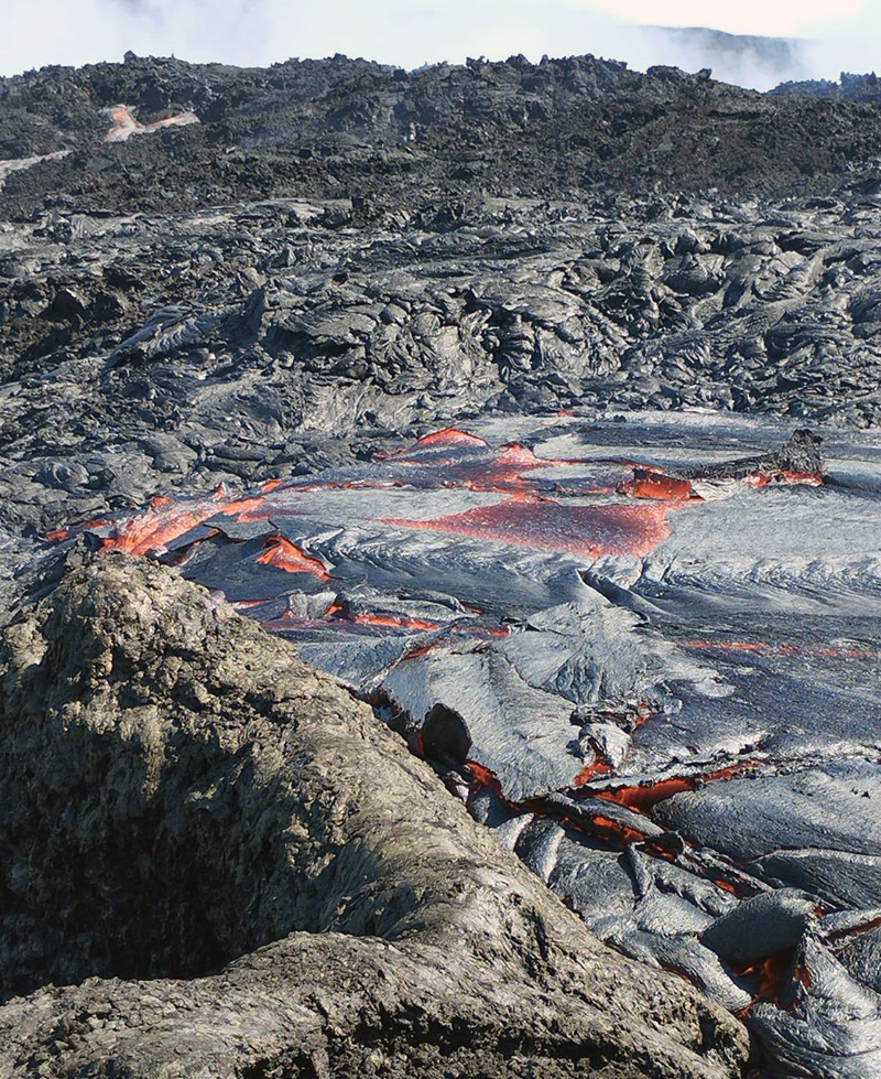 |
Figure 230. Photo of the cooling, corded lava flows in the active vent at Piton de la Fournaise at 1430 on 28 September 2022. Courtesy of OVPF-IPGP. |
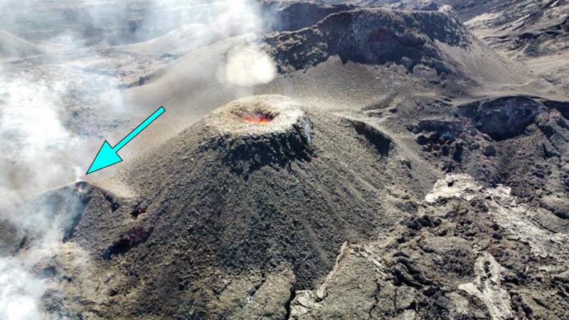 |
Figure 231. Photo of the main eruptive vent at Piton de la Fournaise taken around 1500 on 28 September 2022. To the left of the main cone is a smaller eruptive vent that opened earlier that day (blue arrow). Courtesy of OVPF-IPGP. |
Lava flows and fountains continued during early October, with activity also resuming at the secondary vent (figure 232). Lava mainly flowed through lava tubes, although outbreaks were visible near the eruptive cone. About 24 volcano-tectonic earthquakes were recorded directly over the summit area on 1 October. The lava flow rate ranged between 4-20 m3/s during 1-3 October and peaked at 33 m3/s on 3 October, based on estimates from the HOTVOLC and MIROVA systems. These measurements show that since 28 September there was a gradual increase in the lava flow rate. On 1 October a strong sulfur dioxide plume was visible drifting up to 400 km NW from the volcano with a mass of 1,500 t/d (figure 225). On 3 October, 75 volcano-tectonic earthquakes were detected directly above the summit area. Sulfur dioxide emissions continued to increase and were about 2,500 t/d on 3 October. The eruptive cone had grown to around 12 m tall and 43 m wide at the base. During 3-4 October the lava fountains became less intense and the new smaller cone on the S flank was only weakly active. The southernmost lava flow reached 1,800 m elevation in an area 1.5 km NW of Nez coupé du Tremblet. During 4-5 October tremor levels fluctuated. Lava effusion increased, averaging 10 m/s and peaking at 25 m/s. Lava was ejected above the main vent, which was 23 m wide. The smaller vent was not active. The eruption ended at 0748 on 5 October 2022, according to OVPF, based on visual observations and a sudden stop in tremor signals.
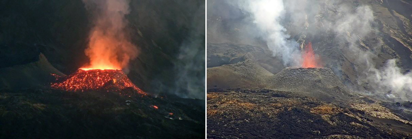 |
Figure 232. Webcam images showing the main eruptive vent at Piton de la Fournaise with gas-and-steam emissions, lava fountains, and incandescence on the cone. Photos were taken at 0544 and 1054 on 1 October 2022 on the left and right, respectively from the webcam located at Piton de Bert. Courtesy of OVPF-IPGP. |
Geological Summary. Piton de la Fournaise is a massive basaltic shield volcano on the French island of Réunion in the western Indian Ocean. Much of its more than 530,000-year history overlapped with eruptions of the deeply dissected Piton des Neiges shield volcano to the NW. Three scarps formed at about 250,000, 65,000, and less than 5,000 years ago by progressive eastward slumping, leaving caldera-sized embayments open to the E and SE. Numerous pyroclastic cones are present on the floor of the scarps and their outer flanks. Most recorded eruptions have originated from the summit and flanks of Dolomieu, a 400-m-high lava shield that has grown within the youngest scarp, which is about 9 km wide and about 13 km from the western wall to the ocean on the E side. More than 150 eruptions, most of which have produced fluid basaltic lava flows, have occurred since the 17th century. Only six eruptions, in 1708, 1774, 1776, 1800, 1977, and 1986, have originated from fissures outside the scarps.
Information Contacts: Observatoire Volcanologique du Piton de la Fournaise, Institut de Physique du Globe de Paris, 14 route nationale 3, 27 ème km, 97418 La Plaine des Cafres, La Réunion, France (URL: http://www.ipgp.fr/fr); Hawai'i Institute of Geophysics and Planetology (HIGP) - MODVOLC Thermal Alerts System, School of Ocean and Earth Science and Technology (SOEST), Univ. of Hawai'i, 2525 Correa Road, Honolulu, HI 96822, USA (URL: http://modis.higp.hawaii.edu/); MIROVA (Middle InfraRed Observation of Volcanic Activity), a collaborative project between the Universities of Turin and Florence (Italy) supported by the Centre for Volcanic Risk of the Italian Civil Protection Department (URL: http://www.mirovaweb.it/); Global Sulfur Dioxide Monitoring Page, Atmospheric Chemistry and Dynamics Laboratory, NASA Goddard Space Flight Center (NASA/GSFC), 8800 Greenbelt Road, Goddard, Maryland, USA (URL: https://so2.gsfc.nasa.gov/).