Report on Semisopochnoi (United States) — December 2022
Bulletin of the Global Volcanism Network, vol. 47, no. 12 (December 2022)
Managing Editor: Edward Venzke.
Edited by Kadie L. Bennis.
Semisopochnoi (United States) Intermittent explosions and ash emissions during June-November 2022
Please cite this report as:
Global Volcanism Program, 2022. Report on Semisopochnoi (United States) (Bennis, K.L., and Venzke, E., eds.). Bulletin of the Global Volcanism Network, 47:12. Smithsonian Institution.
Semisopochnoi
United States
51.93°N, 179.58°E; summit elev. 1221 m
All times are local (unless otherwise noted)
Semisopochnoi is the largest subaerial volcano in the western Aleutians. It is 20-km-wide at sea level and contains an 8-km wide caldera. The three-peaked Mount Cerberus was constructed within the caldera during the Holocene. Each of these peaks contains a summit crater; the lava flows on the N flank appear younger than those on the S side. The current eruption period began in early February 2021 and has recently consisted of numerous weak ash explosions, ash plumes, ashfall, elevated surface temperatures, and sulfur dioxide emissions (BGVN 47:06). This report covers activity during June through November 2022 using daily, weekly, and special reports from the Alaska Volcano Observatory (AVO) and satellite data. AVO monitors the volcano using local seismic and infrasound sensors, satellite data, web cameras, and remote infrasound and lightning networks.
AVO reported low-level activity during June that consisted of elevated seismicity with intermittent tremor and explosions, and frequent gas-and-steam emissions that mostly consisted of sulfur dioxide, that rose above the N crater of Cerberus; weather clouds often obscured satellite and webcam views. Minor ash emissions were visible in webcam images rising to low heights during 6-9 and 11-12 June and extended as far as 40 km from the vent. Similar low-level activity during July prompted AVO to reduce the Aviation Color Code (ACC) and Volcano Alert Level (VAL) to Yellow and Advisory, respectively on 7 July. Low levels of seismicity and elevated surface temperatures were reported. Satellite and webcam images were mostly obscured due to weather clouds, though gas-and-steam emissions were visible from the active crater during 6-7 and 12-14 July.
During August, seismicity consisted of occasional small earthquakes and seismic tremor. Elevated surface temperatures were also recorded. Webcam images, when not obscured by weather clouds, showed gas-and-steam emissions rising from the N crater of Mount Cerberus. A short-lived explosion was detected at 1347 on 21 August, based on observations from local webcams. A low-level ash cloud was observed in webcam data and recorded in seismic and infrasound data that rose no higher than 6 km altitude; specific altitudes were not determined due to weather clouds (figure 23). As a result, the ACC and VAL were raised to Orange and Watch, respectively. Gas-and-steam emissions possibly containing minor amounts of ash were observed in clear satellite images after the explosion.
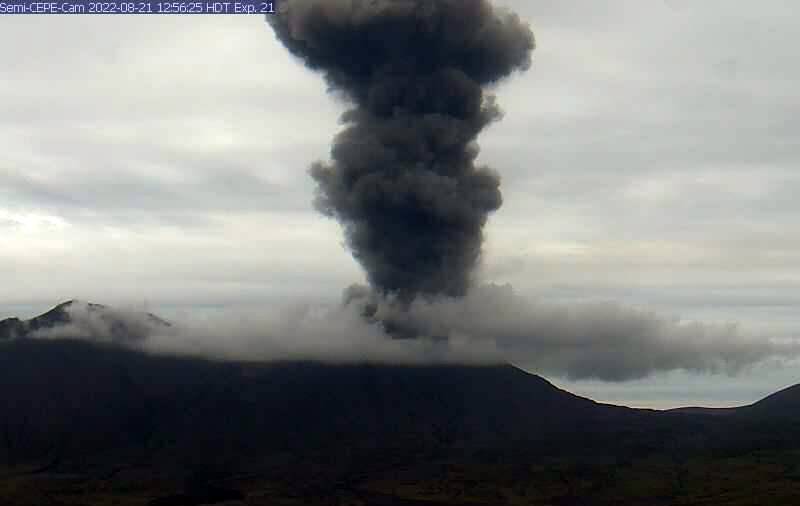 |
Figure 23. Photo of a dense ash plume rising above the N active crater at Mount Cerberus at Semisopochnoi nine minutes after the start of an eruption event on 21 August 2022. Photo by Matt Loewen, courtesy of AVO. |
Gas-and-steam emissions, and seismicity including volcanic tremor, continued during September and October. Several small ash eruptions from the active crater were visible in webcam images and detected in seismic and infrasound data during 2-3 September. During 13-15 September explosions generated ash emissions that rose no higher than 1.2 km altitude and drifted up to 8 km SE. Some local ashfall was observed in cloudy webcam images during 16-17 September. On 3 October an explosion was detected in infrasound data, though no accompanying ash emission was reported. Another small explosion was detected in geophysical data on 31 October.
The active crater continued to emit gas-and-steam emissions during November, and volcanic tremor and small earthquakes persisted, based on geophysical data, since weather clouds often obscured clear views. Small explosions were detected in geophysical data during 7 November; however, ash emissions were not visible in satellite or webcam images. After 7 November seismicity decreased and no explosive activity or ash emissions were observed.
Sentinel-2 satellite imagery showed occasional white gas-and-steam plumes rising above the crater, which sometimes contained ash (figure 24). The plumes drifted in different directions. A small thermal anomaly was detected in the crater on 6 October due to clear weather.
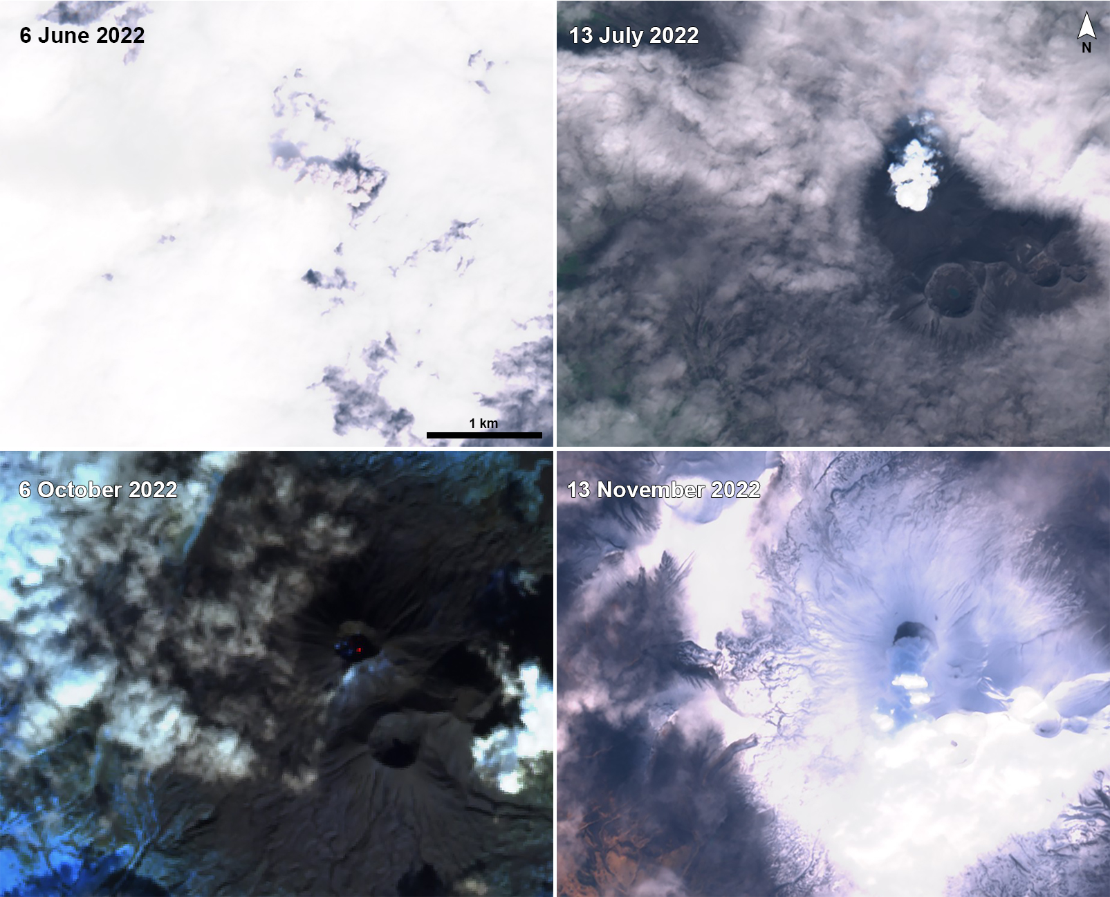 |
Figure 24. Sentinel-2 satellite imagery showed gas-and-steam plumes rising above the active N crater of Mount Cerberus at Semisopochnoi on 6 June 2022 (top left), 13 July 2022 (top right), and 13 November 2022 (bottom right). A weak thermal anomaly was visible in the active crater on 6 October 2022 (bottom left). Plumes drifted NW and S in these images. Images using “Natural color” (bands 4, 3, 2) and “Atmospheric penetration” (bands 12, 11, 8A) rendering. Courtesy of Sentinel Hub Playground. |
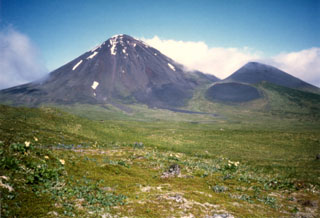
Geological Summary. Semisopochnoi, the largest subaerial volcano of the western Aleutians, is 20 km wide at sea level and contains an 8-km-wide caldera. It formed as a result of collapse of a low-angle, dominantly basaltic volcano following the eruption of a large volume of dacitic pumice. The high point of the island is Anvil Peak, a double-peaked late-Pleistocene cone that forms much of the island's northern part. The three-peaked Mount Cerberus (renamed Mount Young in 2023) was constructed within the caldera during the Holocene. Each of the peaks contains a summit crater; lava flows on the N flank appear younger than those on the south side. Other post-caldera volcanoes include the symmetrical Sugarloaf Peak SSE of the caldera and Lakeshore Cone, a small cinder cone at the edge of Fenner Lake in the NE part of the caldera. Most documented eruptions have originated from Young, although Coats (1950) considered that both Sugarloaf and Lakeshore Cone could have been recently active.
Information Contacts: Alaska Volcano Observatory (AVO), a cooperative program of a) U.S. Geological Survey, 4200 University Drive, Anchorage, AK 99508-4667 USA (URL: https://avo.alaska.edu/), b) Geophysical Institute, University of Alaska, PO Box 757320, Fairbanks, AK 99775-7320, USA, and c) Alaska Division of Geological & Geophysical Surveys, 794 University Ave., Suite 200, Fairbanks, AK 99709, USA (URL: http://dggs.alaska.gov/); Sentinel Hub Playground (URL: https://www.sentinel-hub.com/explore/sentinel-playground).