Report on Mauna Loa (United States) — January 2023
Bulletin of the Global Volcanism Network, vol. 48, no. 1 (January 2023)
Managing Editor: Edward Venzke.
Edited by Kadie L. Bennis.
Mauna Loa (United States) New eruption with lava flows and fountains during November-December 2022
Please cite this report as:
Global Volcanism Program, 2023. Report on Mauna Loa (United States) (Bennis, K.L., and Venzke, E., eds.). Bulletin of the Global Volcanism Network, 48:1. Smithsonian Institution.
Mauna Loa
United States
19.475°N, 155.608°W; summit elev. 4170 m
All times are local (unless otherwise noted)
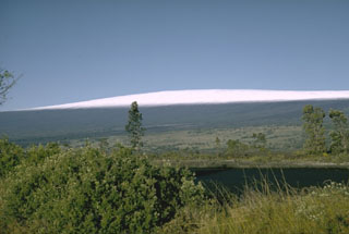
Mauna Loa is a basaltic shield volcano that rises almost 9 km from the ocean floor in Hawaii. Flank eruptions typically occur from NE and SW rift zones, and from the Moku?aweoweo summit caldera. About 1,500 years ago a series of voluminous overflows from a summit lava lake covered about 25% of the volcano’s surface. An eruption during March-April 1984 produced lava flows and fountains (SEAN 09:03). A new eruption during 27 November-10 December 2022 was characterized by lava flows, fountains, and strong sulfur dioxide emissions, based on information from daily reports and volcanic activity notices from the US Geological Survey's (USGS) Hawaiian Volcano Observatory (HVO).
Heightened unrest began at about 0200 on 23 September, when shallow earthquakes increased from 10-20 per day during July-August to 40-50 per day, located underneath Moku?aweoweo caldera (2-5 km below the surface) and in an area NW of the caldera (6-8 km below the surface). Both regions have historically been seismically active during periods of unrest, according to HVO, and this activity was attributed to magma movement. GPS (Global Positioning System) instruments at the summit and on the flanks also measured elevated rates of inflation since mid-September. Peaks in the number of earthquakes were as high as 100 per day on 23 and 29 September. Two Mw 4.6 and Mw 5 earthquakes were recorded at 0907 on 14 October. The former was located S of Pahala at a depth of about 13 km. The second earthquake, 24 seconds later, was located S of Pahala at a depth of 7.4 km. These were followed by more than 150 aftershocks in the Pahala region over the next two days. HVO noted that this unrest was likely driven by the accumulation of new magma 3-8 km below the summit.
HVO reported that a new eruption began in Moku?aweoweo caldera at 2330 on 27 November, which prompted them to raise the Aviation Color Code (ACC) to Red (the highest level on a four-color scale) and the Volcano Alert Level (VAL) to Warning (the highest level on a four-level scale). A thermal anomaly and a plume of sulfur dioxide gas were identified in satellite images at the onset of the eruption, according to NOAA’s National Environmental Satellite, Data, and Information Service (NESDIS). Lava erupted from a fissure in the caldera (figure 27) and by 0127 on 28 November lava had overflowed the low NE caldera wall. During an overflight at about 0630, scientists confirmed that the fissure in the caldera had stopped and several fissures on the upper flank in the Northeast Rift Zone opened and fed active lava flows. The flows were active in the “saddle” area between Mauna Loa and Mauna Kea and several traveled N and NE. Lava flows from Fissures 1 and 2 (F1 and F2, respectively) traveled downslope and stalled about 18 km from Saddle Road; both flows were inactive by 1330 on 28 November. The longest lava flow originated from Fissure 3 (F3), the lowest elevation of the NE fissures at 3.5 km elevation, and crossed the Mauna Loa Weather Observatory Road at approximately 2000 on 28 November; by 0700 on 29 November the flow was about 10 km from Saddle Road. Lava fountains from Fissure 4 (F4), downslope from F3, formed at approximately 1930 on 28 November and rose 5-10 m high. Fountains from F3 were visible during the morning of 29 November and rose 25 m high (figure 28), increasing to 40-50 m high that afternoon. The average sulfur dioxide emission rate measured was 250,000 tons per day (t/d) on 28 November.
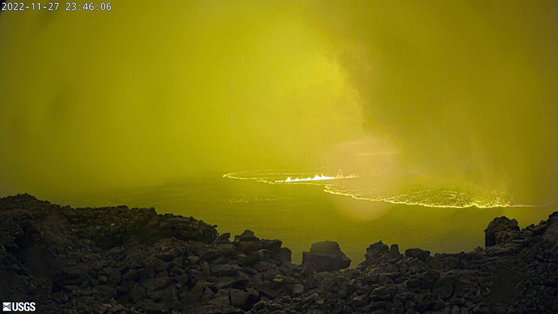 |
Figure 27. Webcam image showing new lava effusion originating from a fissure in the Moku?aweoweo caldera at Mauna Loa at 2346 on 27 November 2022. Courtesy of USGS Hawaiian Volcano Observatory. |
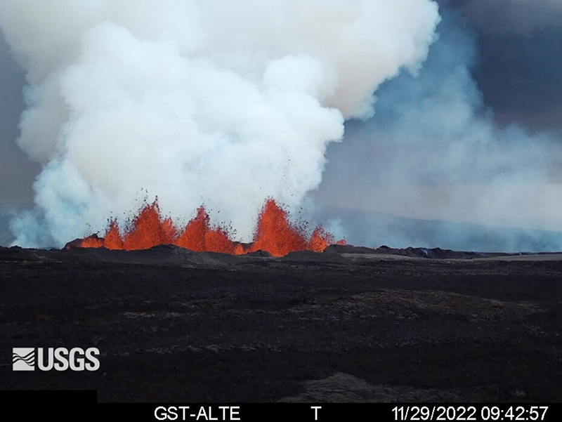 |
Figure 28. Webcam image showing lava fountains at Mauna Loa rising as high as 25 m from Fissure 3 at 0942 on 29 November 2022. Courtesy of USGS Hawaiian Volcano Observatory. |
On 30 November the two active fissures fed lava flows downslope; F3 lava flow traveled NE and during the night of 29-30 November shifted slightly to the W (figure 29). HVO reported that F3 was the dominant source of the main lava flow and that the flow front was about 5.8 km from Saddle Road as of 0700 on 30 November (figure 30). The flows were advancing at a rate of 130 m/hour during 29-30 November. Lava fountains at F3 rose 20-25 m high on 30 November. The F4 flow moved NE at a rate of 50 m/hour; a smaller, branched lobe traveled E from the fissure at a slower rate. Pele’s hair fell in the Saddle Road area. No active lava was reported in Moku?aweoweo caldera or along the Southwest Rift Zone. Gas-and-steam plumes from the activity drifted N.
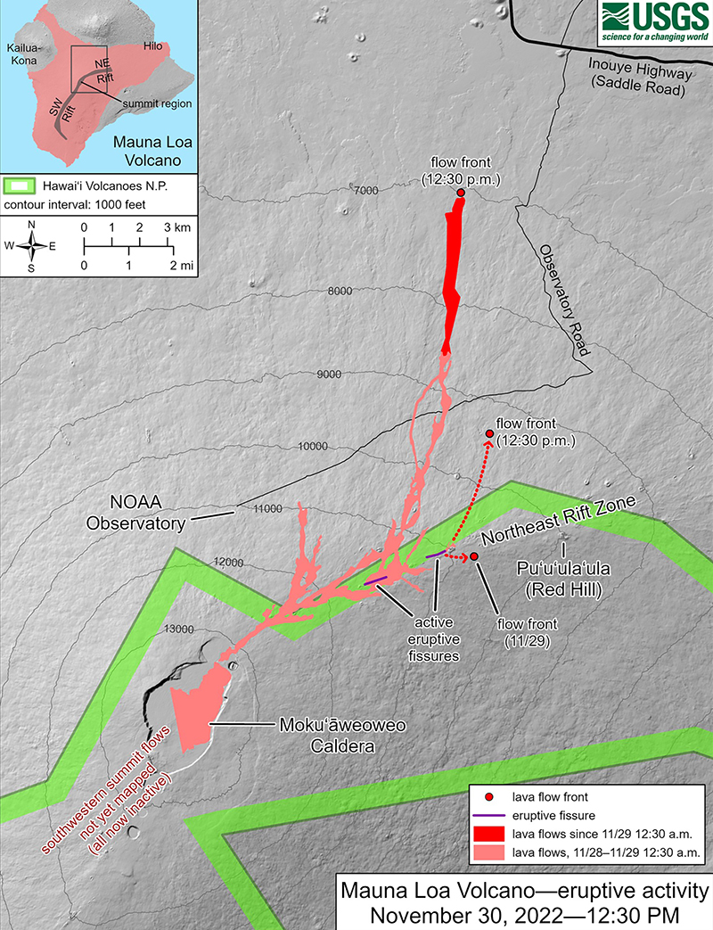 |
Figure 29. Map showing the Mauna Loa lava flow advances during 28-30 November 2022. Fissure 3 is the dominant fissure, feeding flows to the N. The light red color shows lava flows during 28-29 November and the darker red color shows lava flows emplaced from 0030 on 29 November to 1230 on 30 November. The dotted lines indicate flows from Fissure 4, which were moving NE. A smaller lobe from Fissure 4 was moving E. The purple line shows the location of the two active fissures. Courtesy of USGS Hawaiian Volcano Observatory. |
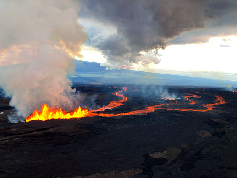 |
Figure 30. Photo of Fissure 3 at Mauna Loa showing strong lava fountains rising 20-25 m high and lava flows that are moving NE at about 130 m/hour. Photo was taken during an overflight during the morning of 30 November 2022. Courtesy of USGS Hawaiian Volcano Observatory. |
On 1 December the F3 lava flows traveled N toward Saddle Road, also referred to as the Daniel K. Inouye Highway, and lava fountaining continued (figure 31); the rate of the largest flow had slowed down during 30 November-1 December to a rate of 40 m/hour. The main flow branched almost halfway down the flow field, but coalesced downslope and advanced along a single flow front that reached about 5.4 km from Saddle Road by 0700 on 1 December. As the flow rate slowed, the flow front widened and became thicker. The F4 flow moved to the NE at a rate of 60 m/hour; the branched lobe that traveled E had stalled by the afternoon of 1 December. Pele’s hair continued to fall in the Humu‘ula Saddle area. During 2 December the F3 lava flow increased to a rate of 45 m/hour and by 0700 the flow front was 4.3 km from Saddle Road. Sulfur dioxide rates measured on 1 December were 180,000 t/d. By 3 December only F3 was active; HVO scientists confirmed that the flow from F4 was no longer active during an overflight during the morning of 3 December. Only incandescent cracks were visible from F4.
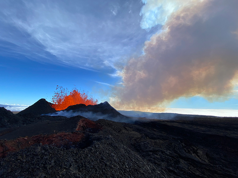 |
Figure 31. Photo of low lava fountains erupting from Fissure 3 at Mauna Loa during the morning of 1 December 2022. Courtesy of USGS Hawaiian Volcano Observatory. |
The active lava flow from F3 continued to move N; by 0700 during the morning of 3 December the flow front was about 4 km from the Saddle Road. The flow had advanced at a rate of about 13 m/hour. Several small overflows near where the main lava flow branched, on the steeper slopes of the NE flank about halfway down the lava flow, were seen during 3-6 December. Lava fountains during 3-4 December rose 33 m high, increasing to 40-100 m on 6 December; fragments of volcanic material were deposited in the area near the vent. Molten lava bombs were sometimes ejected during the fountaining, which cooled at the base of the fissure and built a significant spatter cone. Pele’s hair fragments were blown to distances as far as Laupahoehoe (59 km NW of F3) during 3-7 December. The F3 lava flow front had advanced to 3.6 km from Saddle Road when measured at 0700 on 4 December, and the average flow rate was 12 m/hour. On 4 December the sulfur dioxide emission rate was approximately 120,000 t/d. The ACC was lowered to Orange (the second highest level on a four-color scale) at 0810 on 4 December; the VAL remained at Warning, which reflected the ongoing lava flow hazards.
The active lava flow front that originated from F3 was about 3.5 km from Saddle Road at 0630 on 5 December. Around this time the lava flow rate was about 8 m/hour; a brief surge at the flow front was recorded during the morning. The average flow rate during 5-6 December was 21 m/hour, but for short periods increased up to 27.4 m/hour. By 0500 on 6 December the flow front was about 3.1 km from Saddle Road. The flow front was 2.9 km from Saddle Road at 0600 on 7 December; the flow advanced only a short distance since 0000, likely because a significant breakout had occurred about 4.5 km upslope of the flow front on the E side. The main flow averaged a rate of 6 m/hour during 6-7 December. HVO crews installed a new webcam to observe the front of the main flow during this time.
Though F3 continued to erupt during the morning of 8 December, HVO reported that the volume of lava had notably decreased. Lava overflowed some channels near the vent, which extended no farther than 4-4.4 km. By 0530 on 8 December the main active flow front was stalled about 2.8 km from Saddle Road; the lower part of the flow was inactive. Sulfur dioxide measurements declined to an emission rate of 30,000 t/d. The inactive main flow remained stagnant at 2.8 km from Saddle Road, as measured during the afternoon of 8 December, though HVO reported that as the flow front settled it moved slowly N about 2 m/hour. At 0700 on 9 December activity at the F3 vent was significantly reduced and by 1130 low fountains fed lava flows that extended as far as 2.65 km NE from the vent.
HVO reported that the eruption stopped on 10 December as lava supply to F3 on the Northeast Rift Zone had stopped and sulfur dioxide emissions had decreased to pre-eruption background levels (figure 32). Volcanic tremor and earthquakes associated with the eruption had also greatly decreased. A lava pond replaced the fountaining at the F3 vent at 0700 on 10 December. The pond fed short lava flows that extended 2.6 km from the vent, but then quickly began to stagnate. Lava was confined to the small pond by 1435. The main flow front was inactive but still showed nighttime incandescence. HVO lowered the VAL to Watch (the second highest level on a four-level scale) on 10 December at 1435 and the ACC remained at Orange.
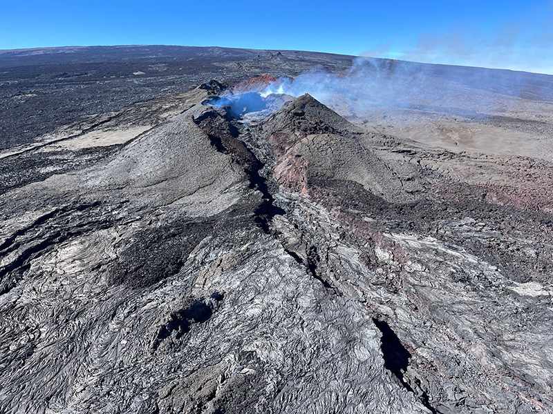 |
Figure 32. Photo of Fissure 3 at Mauna Loa taken during the morning of 10 December 2022 showing an inactive lava flow and weak gas-and-steam emissions. Courtesy of USGS Hawaiian Volcano Observatory. |
Webcam views showed little incandescence and no lava movement in the F3 vent by 0700 on 11 December. Incandescence was restricted to the cone that had formed around the F3 vent. Sulfur dioxide emission rates on 9 December were 20,000 t/d, but when measured the next day had decreased to 2,000 t/d. During an early morning overflight on 12 December scientists heard a small explosion that accompanied a spray of spatter from the W end of F3. On 13 December the ACC was lowered to Yellow. On 14 December HVO reported that the volcano was no longer erupting; webcams only captured residual incandescence and there was no lava movement in the F3 vent. The inactive main flow remained 2.8 km from Saddle Road when last measured during the morning of 10 December.
Geological Summary. Massive Mauna Loa is a basaltic shield volcano that rises almost 9 km from the ocean floor to form the world's largest Holocene volcano. Flank eruptions typically occur from the lengthy NE and SW rift zones, and from the Moku'aweoweo summit is caldera, which is within an older and larger 6 x 8 km caldera. Two of the youngest large debris avalanches documented in Hawaii traveled nearly 100 km from Mauna Loa; the second of the Alika avalanches was emplaced about 105,000 years ago (Moore et al., 1989). Almost 90% of the surface of the volcano is covered by lavas less than 4,000 years old (Lockwood and Lipman, 1987). Beginning about 1,500 years ago, a series of voluminous overflows from a summit lava lake covered about 25% of the volcano's surface. Over the last 750 years, from shortly after the formation of Moku'aweoweo caldera until the present, an additional 25% of the volcano has been covered with lava flows, mainly from summit and NW rift zone vents.
Information Contacts: Hawaiian Volcano Observatory (HVO), U.S. Geological Survey, PO Box 51, Hawai'i National Park, HI 96718, USA (URL: http://hvo.wr.usgs.gov/); National Environmental Satellite, Data, and Information Service (NESDIS), NOAA, 1335 East-West Highway, SSMC1, 8th Floor Suite 8300, Silver Spring, MD 20910 (URL: https://www.nesdis.noaa.gov/, https://twitter.com/NOAASatellites/status/1597231244060004352).