Report on Nevado del Ruiz (Colombia) — February 2023

Bulletin of the Global Volcanism Network, vol. 48, no. 2 (February 2023)
Managing Editor: Edward Venzke.
Edited by Kadie L. Bennis.
Nevado del Ruiz (Colombia) Gas-and-ash emissions, dome growth, and seismicity continued during August 2022-January 2023
Please cite this report as:
Global Volcanism Program, 2023. Report on Nevado del Ruiz (Colombia) (Bennis, K.L., and Venzke, E., eds.). Bulletin of the Global Volcanism Network, 48:2. Smithsonian Institution.
Nevado del Ruiz
Colombia
4.892°N, 75.324°W; summit elev. 5279 m
All times are local (unless otherwise noted)
Nevado del Ruiz is a broad, glacier-covered volcano in central Colombia that covers more than 200 km2. It contains the 1-km-wide, 240-m-deep Arenas summit crater. Eruptions have been documented since 1570 CE. The current eruption period has been ongoing since November 2014 and more recently has consisted of intermittent ash emissions, thermal activity, and lava dome growth (BGVN 47:08). This report updates activity including gas-and-ash emissions, dome growth, and seismicity during August 2022 through January 2023 using information from the Servicio Geologico Colombiano (SGC) and the Observatorio Vulcanológico y Sismológico de Manizales, the Washington Volcanic Ash Advisory Center (VAAC) notices, and various satellite data.
Intermittent thermal anomalies were recorded during August 2022 through January 2023, with three peaks of strong and frequent hotspots detected during late October, mid-December, and late January, according to the MIROVA graph (Log Radiative Power) (figure 140). Some of this thermal activity was also visible in Sentinel-2 infrared satellite imagery, occasionally accompanied by white gas-and-steam emissions (figure 141). According to data from the TROPOMI instrument on the Sentinel-5P satellite, sulfur dioxide plumes were also detected throughout the reporting period, many of which had a maximum mass that exceeded 2 Dobson Units (DU) and drifted in different directions (figure 142).
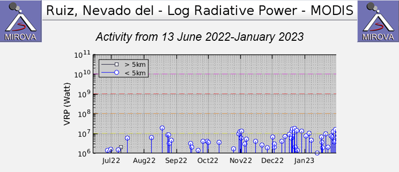 |
Figure 140. Intermittent thermal anomalies were detected at Nevado del Ruiz during August 2022 through January 2023, according to this MIROVA graph (Log Radiative Power). Slightly stronger and more frequent anomalies were detected during late October, mid-December, and late January. Two gradual declines in both power and frequency were observed during November and late-December. Courtesy of MIROVA. |
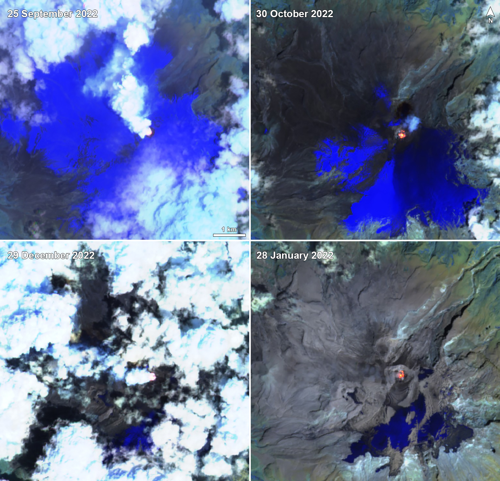 |
Figure 141. Sentinel-2 infrared satellite images showed an occasional thermal anomaly at the summit crater of Nevado del Ruiz, seen here on 25 September 2022 (top left), 30 October 2022 (top right), 29 December 2022 (bottom left), and 28 January 2023 (bottom right). Sometimes white gas-and-steam emissions accompanied the thermal activity, as shown on 25 September, 30 October, and 29 December. Images use “Atmospheric penetration” rendering (bands 12, 11, 8a). Courtesy of Sentinel Hub Playground. |
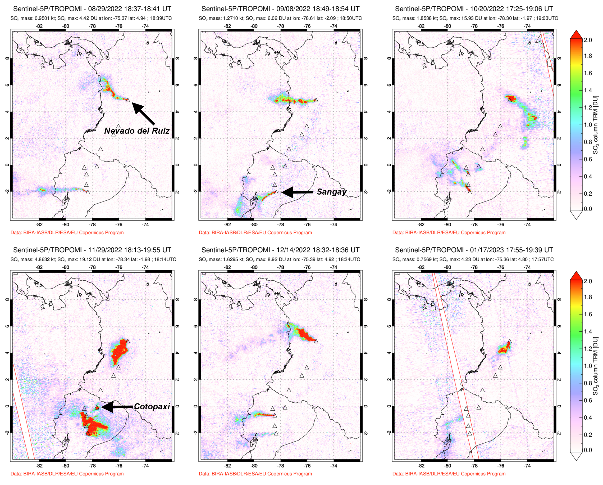 |
Figure 142. Sulfur dioxide emissions from Nevado del Ruiz were often recorded during August 2022 through January 2023 with the TROPOMI instrument on the Sentinel-5P satellite. Plumes drifted in different directions and often exceeded 2 Dobson Units (DU) on 29 August 2022 (top left), 8 September 2022 (top middle), 20 October 2022 (top right), 29 November 2022 (bottom left), 14 December 2022 (bottom middle), and 17 January 2023 (bottom right). Courtesy of NASA Global Sulfur Dioxide Monitoring Page. |
Activity during August and September remained relatively low, consisting of seismicity and gas-and-ash emissions and continued lava dome growth in the Arenas crater. Seismic events included volcanic tremor, tremor pulses, and very long period earthquakes. Gas-and-ash emissions were associated with some of these seismic signals. Additionally, occasional drumbeat-type seismicity, associated with rock fracturing and the evolution of the growing lava dome, was reported. Gas-and-ash emissions rose to 2 km above the summit during 4-5 August and drifted NW, W, and SW. As a result, ash fell in the nearby towns of Santa Rosa de Cabal (33 km W), Pereira (40 km WSW), Villamaría (28 km NW), and Manizales (25 km N). On 12, 18, and 25 August gas-and-steam plumes rose 2-3.2 km above the summit and drifted NW, W, and SW; a gas-and-ash emission was reported at 1751 on 18 August and rose 3.2 km above the summit and drifted WNW. During the week of 23-30 August gas-and-ash emissions resulted in ashfall in Villamaría and Manizales. Gas-and-steam emissions rose 2.3-2.5 km above the summit on 10, 13, 26, and 28 September and drifted NW, W, SW, WNW, N, and NE.
During October and November similar low levels of seismicity, dome growth, and plumes of gas-and-steam plumes (mostly sulfur dioxide) with some ash, persisted. Gas-and-steam emissions rose 1.8-2.9 km above the summit on 5, 13, 22, and 31 October and drifted in various directions. SGC reported that there was an increase in sulfur dioxide degassing values on 20 October, with the maximum recorded mass value of approximately 5,000 tons. Gas-and-steam emissions rose 1.8-2.2 km above the summit on 4, 8, 16, and 25 November and drifted NW, SW, SE, ESE, and NE. According to data from the Washington VAAC, ash plumes rose to 6.4-7.3 km altitude and drifted S and SE on 11 November based on satellite and webcam images. During 13-14 November ash plumes rose to 6.7 km altitude and drifted NE.
Seismicity and gas-and-steam emissions continued during December and January 2023. Pulses of gas-and-ash emissions associated with seismic signals were also reported. Additionally, people in the municipalities of Tolima and Manizales (Caldas) reported sightings of continuous ash emissions during 2-13 December. Gas-and-steam emissions rose 1.7-2.9 km above the summit on 2, 13, 21, and 31 December and drifted SW, SE, SSE, NE, W, and NW. On 7 December gas-and-steam and ash emissions rose 2 km above the summit and drifted W. Ashfall was detected in Dosquebradas (40 km WSW), Santa Rosa de Cabal (34 km W), and Pereira (40 km WSW in Risaralda), Manizales (27 km NW) and Villamaría (26 km NW in Caldas), and in the Los Nevados National Natural Park sector on 14 December and to the N near Tolima during 3-9 January as ash emissions continued intermittently for several hours at a time. Gas-and-steam emissions rose 1.3-2.9 km above the summit and drifted in different directions on 6, 14, 22, 25 January. An ash cloud was observed at 0706 on 6 January that caused ashfall in Villahermosa (27 km NE). On 23 January ashfall was reported in Manizales and on 29 January ash was remobilized and caused ashfall in Eje Cafetero.
Geological Summary. Nevado del Ruiz is a broad, glacier-covered volcano in central Colombia that covers more than 200 km2. Three major edifices, composed of andesitic and dacitic lavas and andesitic pyroclastics, have been constructed since the beginning of the Pleistocene. The modern cone consists of a broad cluster of lava domes built within the caldera of an older edifice. The 1-km-wide, 240-m-deep Arenas crater occupies the summit. The prominent La Olleta pyroclastic cone located on the SW flank may also have been active in historical time. Steep headwalls of massive landslides cut the flanks. Melting of its summit icecap during historical eruptions, which date back to the 16th century, has resulted in devastating lahars, including one in 1985 that was South America's deadliest eruption.
Information Contacts: Servicio Geologico Colombiano (SGC), Diagonal 53 No. 34-53 - Bogotá D.C., Colombia (URL: https://www.sgc.gov.co/volcanes); Washington Volcanic Ash Advisory Center (VAAC), Satellite Analysis Branch (SAB), NOAA/NESDIS OSPO, NOAA Science Center Room 401, 5200 Auth Rd, Camp Springs, MD 20746, USA (URL: www.ospo.noaa.gov/Products/atmosphere/vaac, archive at: http://www.ssd.noaa.gov/VAAC/archive.html); MIROVA (Middle InfraRed Observation of Volcanic Activity), a collaborative project between the Universities of Turin and Florence (Italy) supported by the Centre for Volcanic Risk of the Italian Civil Protection Department (URL: http://www.mirovaweb.it/); NASA Global Sulfur Dioxide Monitoring Page, Atmospheric Chemistry and Dynamics Laboratory, NASA Goddard Space Flight Center (NASA/GSFC), 8800 Greenbelt Road, Goddard MD 20771, USA (URL: https://so2.gsfc.nasa.gov/); Sentinel Hub Playground (URL: https://www.sentinel-hub.com/explore/sentinel-playground).