Report on Barren Island (India) — April 2023

Bulletin of the Global Volcanism Network, vol. 48, no. 4 (April 2023)
Managing Editor: Benjamin Andrews.
Edited by Kadie L. Bennis.
Barren Island (India) Thermal activity during December 2022-March 2023
Please cite this report as:
Global Volcanism Program, 2023. Report on Barren Island (India) (Bennis, K.L., and Andrews, B., eds.). Bulletin of the Global Volcanism Network, 48:4. Smithsonian Institution.
Barren Island
India
12.278°N, 93.858°E; summit elev. 354 m
All times are local (unless otherwise noted)
Barren Island is part of a N-S-trending volcanic arc extending between Sumatra and Burma (Myanmar). The caldera, which is open to the sea on the west, was created during a major explosive eruption in the late Pleistocene that produced pyroclastic flow and surge deposits. Eruptions dating back to 1787, have changed the morphology of the pyroclastic cone in the center of the caldera, and lava flows that fill much of the caldera floor have reached the sea along the western coast. Previous activity was detected during mid-May 2022, consisting of intermittent thermal activity. This report covers June 2022 through March 2023, which included strong thermal activity beginning in late December 2022, based on various satellite data.
Activity was relatively quiet during June through late December 2022 and mostly consisted of low-power thermal anomalies, based on the MIROVA (Middle InfraRed Observation of Volcanic Activity) graph. During late December, a spike in both power and frequency of thermal anomalies was detected (figure 58). There was another pulse in thermal activity in mid-March, which consisted of more frequent and relatively strong anomalies.
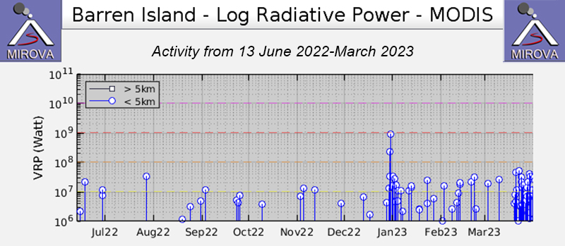 |
Figure 58. Occasional thermal anomalies were detected during June through late December 2022 at Barren Island, but by late December through early January 2023, there was a marked increase in thermal activity, both in power and frequency, according to this MIROVA graph (Log Radiative Power). After this spike in activity, anomalies occurred at a more frequent rate. In late March, another pulse in activity was detected, although the power was not as strong as that initial spike during December-January. Courtesy of MIROVA. |
The Suomi NPP/VIIRS sensor data showed five thermal alerts on 29 December 2022. The number of alerts increased to 19 on 30 December. According to the Darwin VAAC, ash plumes identified in satellite images captured at 2340 on 30 December and at 0050 on 31 December rose to 1.5 km altitude and drifted SW. The ash emissions dissipated by 0940. On 31 December, a large thermal anomaly was detected; based on a Sentinel-2 infrared satellite image, the anomaly was relatively strong and extended to the N (figure 59).
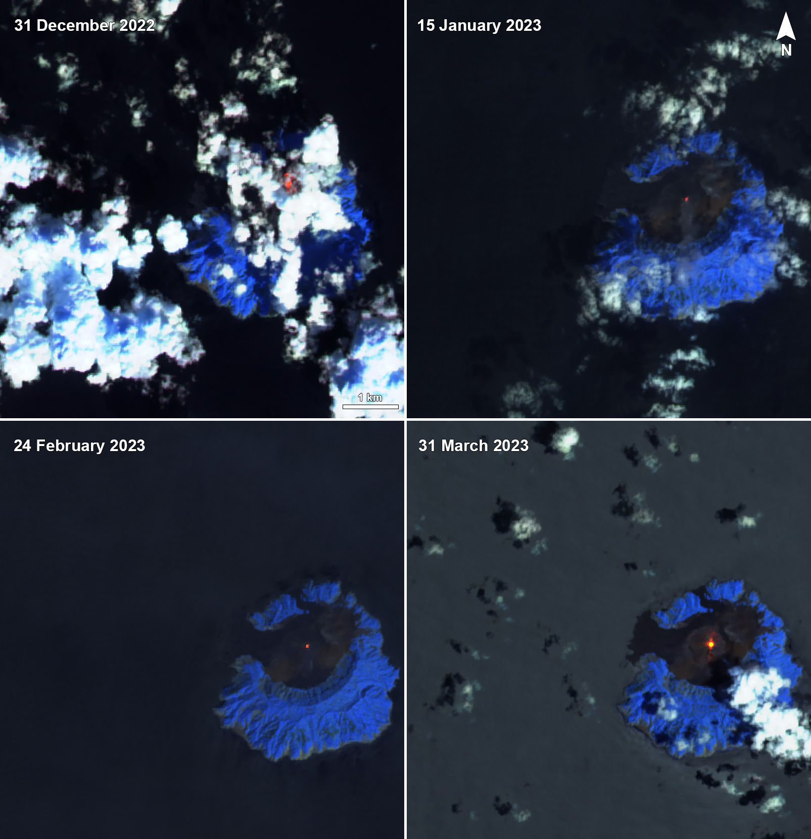 |
Figure 59. Thermal anomalies of varying intensities were visible in the crater of Barren Island on 31 December 2022 (top left), 15 January 2023 (top right), 24 February 2023 (bottom left), and 31 March 2023 (bottom right), as seen in these Sentinel-2 infrared satellite images. The anomalies on 31 December and 31 March were notably strong and extended to the N and N-S, respectively. Images using “Atmospheric penetration” rendering (bands 12, 11, 8a). Courtesy of Sentinel Hub Playground. |
Thermal activity continued during January through March. Sentinel-2 infrared satellite data showed some thermal anomalies of varying intensity on clear weather days on 5, 10, 15, 20, and 30 January 2023, 9, 14, 19, and 24 February 2023, and 21, 26, and 31 March (figure 59). According to Suomi NPP/VIIRS sensor data, a total of 30 thermal anomalies were detected over 18 days on 2-3, 7, 9-14, 16-17, 20, 23, 25, and 28-31 January. The sensor data showed a total of six hotspots detected over six days on 1, 4-5, and 10-12 February. During March, a total of 33 hotspots were visible over 11 days on 20-31 March. Four MODVOLC thermal alerts were issued on 25, 27, and 29 March.
Geological Summary. Barren Island, a possession of India in the Andaman Sea about 135 km NE of Port Blair in the Andaman Islands, is the only historically active volcano along the N-S volcanic arc extending between Sumatra and Burma (Myanmar). It is the emergent summit of a volcano that rises from a depth of about 2250 m. The small, uninhabited 3-km-wide island contains a roughly 2-km-wide caldera with walls 250-350 m high. The caldera, which is open to the sea on the west, was created during a major explosive eruption in the late Pleistocene that produced pyroclastic-flow and -surge deposits. Historical eruptions have changed the morphology of the pyroclastic cone in the center of the caldera, and lava flows that fill much of the caldera floor have reached the sea along the western coast.
Information Contacts: Darwin Volcanic Ash Advisory Centre (VAAC), Bureau of Meteorology, Northern Territory Regional Office, PO Box 40050, Casuarina, NT 0811, Australia (URL: http://www.bom.gov.au/info/vaac/); MIROVA (Middle InfraRed Observation of Volcanic Activity), a collaborative project between the Universities of Turin and Florence (Italy) supported by the Centre for Volcanic Risk of the Italian Civil Protection Department (URL: http://www.mirovaweb.it/); Hawai'i Institute of Geophysics and Planetology (HIGP) - MODVOLC Thermal Alerts System, School of Ocean and Earth Science and Technology (SOEST), Univ. of Hawai'i, 2525 Correa Road, Honolulu, HI 96822, USA (URL: http://modis.higp.hawaii.edu/); Sentinel Hub Playground (URL: https://www.sentinel-hub.com/explore/sentinel-playground); NASA Worldview (URL: https://worldview.earthdata.nasa.gov/).