Report on Merapi (Indonesia) — April 2023

Bulletin of the Global Volcanism Network, vol. 48, no. 4 (April 2023)
Managing Editor: Benjamin Andrews.
Edited by Kadie L. Bennis.
Merapi (Indonesia) Intermittent incandescent avalanches of material and pyroclastic flows during October 2022-March 2023
Please cite this report as:
Global Volcanism Program, 2023. Report on Merapi (Indonesia) (Bennis, K.L., and Andrews, B., eds.). Bulletin of the Global Volcanism Network, 48:4. Smithsonian Institution.
Merapi
Indonesia
7.54°S, 110.446°E; summit elev. 2910 m
All times are local (unless otherwise noted)
Merapi is located just north of the major city of Yogyakarta in central Java, Indonesia. Pyroclastic flows and lahars accompanying growth and collapse of the steep-sided active summit lava dome over the last 20 years have occurred on the western to southern flanks, resulting in many fatalities. The current eruption period began in late December 2020 and has since September 2021 consisted of frequent avalanches of material, crater incandescence, and occasional pyroclastic flows (BGVN 47:10). This report updates information during October 2022 through March 2023, based on information from Balai Penyelidikan dan Pengembangan Teknologi Kebencanaan Geologi (BPPTKG), the Center for Research and Development of Geological Disaster Technology, a branch of PVMBG which specifically monitors Merapi. Additional information comes from the Pusat Vulkanologi dan Mitigasi Bencana Geologi (PVMBG, also known as Indonesian Center for Volcanology and Geological Hazard Mitigation, CVGHM), MAGMA Indonesia, the Darwin Volcanic Ash Advisory Centre (VAAC), and various satellite data.
Activity was relatively low during October 2022 through February 2023 and mainly consisted of frequent white gas-and-steam emissions that rose 10-600 m above the summit and an average of about 2 or fewer avalanches of material per day that affected the SW and W flanks (table 24). Shallow and deep volcanic earthquakes were occasionally recorded. Activity notably increased during 11-15 March, which consisted of tens of pyroclastic flows during this time, ash plumes, and several incandescent avalanches of material.
Table 24. Monthly summary of avalanches and avalanche distances recorded at Merapi during October 2022 through March 2023. The number of reported avalanches does not include instances where possible avalanches were heard but could not be visually confirmed as a result of inclement weather. Data courtesy of BPPTKG (October 2022-March 2023 daily reports).
| Month | Average number of avalanches per day | Distance avalanches traveled (m) |
| Oct 2022 | 2.2 | 800-1,800 |
| Nov 2022 | 1.7 | 800-1,800 |
| Dec 2022 | 1.3 | 500-1,600 |
| Jan 2023 | 1.8 | 500-2,000 |
| Feb 2023 | 1 | 1,700-1,800 |
| Mar 2023 | 22.6 | 1,200-2,500 |
BPPTKG reported that during October and November white gas-and-steam emissions rose 15-600 m above the summit, avalanches of material descended 800-1,800 on the SW and W flanks, and seismicity. Foggy weather often prevented clear views of the summit, so sometimes avalanches could not be verified. A seismometer detected a pyroclastic flow on 11 November at 0905 that lasted 135 seconds; it descended 1 km on the SW flank. A second pyroclastic flow was detected at 1208 later that day, lasting 104 seconds and descending 1 km down the SW flank. In addition, an incandescent avalanche of material traveled 1.1 km to the SW, though the time was not recorded. On 12 November an avalanche traveled 800 m down the SW flank, and two avalanches descended the SW flank for 1.5 km on 15 November. According to a Darwin VAAC report, an ash plume rose to 4.6 km altitude and drifted SW at 0950 on 25 November.
During December 2022 and January 2023, similar activity persisted, with detected seismicity, white gas-and-steam emissions that rose 10-200 m above the summit, occasional incandescent avalanches of material traveled 800-2,000 m down the SW and W flanks. On 19 December a collapse generated an avalanche of material that traveled 1.5 km down the SW flank. A pyroclastic flow on 30 December descended 900 m to the W. On 13 January a collapse generated an avalanche that moved 1.5 km down the SW flank. Avalanches of material during 19 January traveled as far as 2 km on the SW flank.
Occasional white gas-and-steam emissions during February rose 20-75 m above the crater, seismicity continued, and intermittent incandescent avalanches of material traveled 1.7-1.8 km to the SW. On 8 February at 0710 a pyroclastic flow was detected, lasting 130 seconds and traveling 1.5 km to the SW. Ashfall was reported in areas downwind including Sangup, Musuk, and Mriyan.
Increased activity was reported during March, which consisted of some white gas-and-steam emissions, seismicity, incandescent avalanches of material, pyroclastic flows, ash plumes, and ashfall. White gas-and-steam emissions rose 20-550 m above the summit. Incandescent avalanches traveled 1.2-2.5 km to the SW, often accompanied by rock fall events. A VONA issued on 11 March reported that an ash plume at 1212 and 1306 rose 3 km above the summit and drifted W to NW, causing ashfall in several areas downwind, especially in Magelang. During 1212-1500 a series of 21 avalanches of material from the SW lava dome produced 41 pyroclastic flows that traveled as far as 4 km down the SW flank (figure 132). On 12 March at 0708 and 1619 ash plumes rose 2-2.5 km above the summit and drifted N, NW, W, and E, based on information from a ground observer. There were 21 pyroclastic flows on 12 March that traveled as far as 2 km SW (figure 133). In addition, 15 avalanches of material traveled 2.5 km down the SW flank. During 11-12 March ashfall of varying intensities was deposited in areas to the W, NW, and N including in the Dukun District, Sawangan, Magelang Regency; Magelang City; Selo District, Boyolali Regency; and Ambarawa, Jambu, Sumowono, Pringapus, Banyubiru, Bawen Districts, Semarang Regency. Two pyroclastic flows on 13 March descended the SW flank as far as 1.5 km.
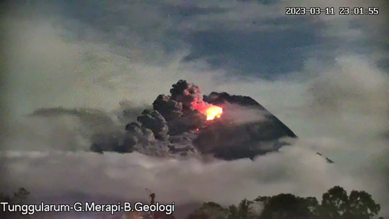 |
Figure 132. Webcam image showing summit crater incandescence accompanied by a pyroclastic flow descending the SW flank of Merapi at 2301 on 11 March 2023. Courtesy of BPPTKG. |
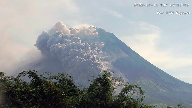 |
Figure 133. Webcam image showing a pyroclastic flow from Merapi on 12 March 2023 at 0757 descending the SW flank. Courtesy of BPPTKG. |
By 13 March a total of 60 pyroclastic flows had mainly affected the Bebeng drainage (SW flank) since 11 March. According to the Darwin VAAC at 0100, 0630, and 0900 ash plumes rose as high as 1.4 km above the summit and drifted NW. A VONA issued on 14 March reported a gray-and-brown ash plume that rose 2.5 km above the summit and drifted E and SE. On 14 March at 0550 pyroclastic flows generated an ash plume that rose 1.5 km above the summit and drifted E to SE. Three pyroclastic flows on the same day traveled 1.3 km down the SW flank. On 15 March three pyroclastic flows descended 1.3 km down the SW flank and at 1036 an ash plume rose 1.2 km above the summit and drifted E. According to the Darwin VAAC ash plumes rose to 1.2 km above the summit and drifted S and W, based on webcam images on 15 and 17 March. Two pyroclastic flows were observed on the SW flank that traveled 2 km on 30 March. Morphological changes were observed in the SW lava dome based on webcam and drone images. The volume of the dome before 11 March was 2,759,100 cubic meters and by 13 March the volume had decreased to 1,686,200 cubic meters, a reduction of nearly 40%. The volume of the summit dome remained unchanged and was estimated at 2,312,100 cubic meters.
MODVOLC thermal alerts detected two thermal anomalies on 11 and 12 March 2023, likely represented by the increased number of incandescent avalanches of material and accompanying pyroclastic flows. A Sentinel-2 infrared satellite image taken on 29 March showed a still active incandescent avalanche descending the SW flank (figure 134).
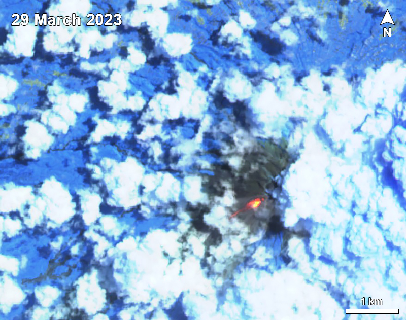 |
Figure 134. Sentinel-2 infrared satellite image taken on 29 March 2023 showed an incandescent avalanche of material descending the SW flank of Merapi. Image uses Atmospheric penetration rendering (bands 12, 11, 8a). Courtesy of Sentinel Hub Playground. |
Geological Summary. Merapi, one of Indonesia's most active volcanoes, lies in one of the world's most densely populated areas and dominates the landscape immediately north of the major city of Yogyakarta. It is the youngest and southernmost of a volcanic chain extending NNW to Ungaran volcano. Growth of Old Merapi during the Pleistocene ended with major edifice collapse perhaps about 2,000 years ago, leaving a large arcuate scarp cutting the eroded older Batulawang volcano. Subsequent growth of the steep-sided Young Merapi edifice, its upper part unvegetated due to frequent activity, began SW of the earlier collapse scarp. Pyroclastic flows and lahars accompanying growth and collapse of the steep-sided active summit lava dome have devastated cultivated lands on the western-to-southern flanks and caused many fatalities.
Information Contacts: Balai Penyelidikan dan Pengembangan Teknologi Kebencanaan Geologi (BPPTKG), Center for Research and Development of Geological Disaster Technology (URL: http://merapi.bgl.esdm.go.id/, Twitter: @BPPTKG); MAGMA Indonesia, Kementerian Energi dan Sumber Daya Mineral (URL: https://magma.esdm.go.id/v1); Pusat Vulkanologi dan Mitigasi Bencana Geologi (PVMBG, also known as Indonesian Center for Volcanology and Geological Hazard Mitigation, CVGHM), Jalan Diponegoro 57, Bandung 40122, Indonesia (URL: http://www.vsi.esdm.go.id/); Hawai'i Institute of Geophysics and Planetology (HIGP) - MODVOLC Thermal Alerts System, School of Ocean and Earth Science and Technology (SOEST), Univ. of Hawai'i, 2525 Correa Road, Honolulu, HI 96822, USA (URL: http://modis.higp.hawaii.edu/); Sentinel Hub Playground (URL: https://www.sentinel-hub.com/explore/sentinel-playground).