Report on Piton de la Fournaise (France) — September 2023
Bulletin of the Global Volcanism Network, vol. 48, no. 9 (September 2023)
Managing Editor: Benjamin Andrews.
Edited by Kadie L. Bennis.
Piton de la Fournaise (France) New eruption characterized by lava fountains and flows during July-August 2023
Please cite this report as:
Global Volcanism Program, 2023. Report on Piton de la Fournaise (France) (Bennis, K.L., and Andrews, B., eds.). Bulletin of the Global Volcanism Network, 48:9. Smithsonian Institution.
Piton de la Fournaise
France
21.244°S, 55.708°E; summit elev. 2632 m
All times are local (unless otherwise noted)
Piton de la Fournaise is a massive basaltic shield volcano on the French island of Réunion in the western Indian Ocean. Most recorded eruptions have originated from the summit and flanks of Dolomieu, a 400-m-high lava shield that grew within the youngest scarp, which is about 9 km wide and extends about 13 km from the W wall to the ocean on the E side. More than 150 eruptions, a majority of which have consisted of basaltic lava flows, have been recorded since the 17th century. The most recent eruption ended in October 2022, and was characterized by lava fountains, flows and strong sulfur dioxide emissions (BGVN 47:12). This report describes a new eruption with lava fountains, flows, and strong sulfur dioxide emissions during July through August 2023 using information from the Observatoire Volcanologique du Piton de la Fournaise (OVPF) and satellite data.
An increase in seismicity was observed beginning on 10 June; nine volcano-tectonic (VT)-type events were recorded on 10 June, eight on 11 June, and 40 on 12 June. These events had low (less than Mw 1) magnitudes, and some were located between 1.5-2 km deep under the Dolomieu crater. During June, 791 VT-type earthquakes, two deep earthquakes, 18 long-period (LP)-type earthquakes, and 163 rockfall events were recorded.
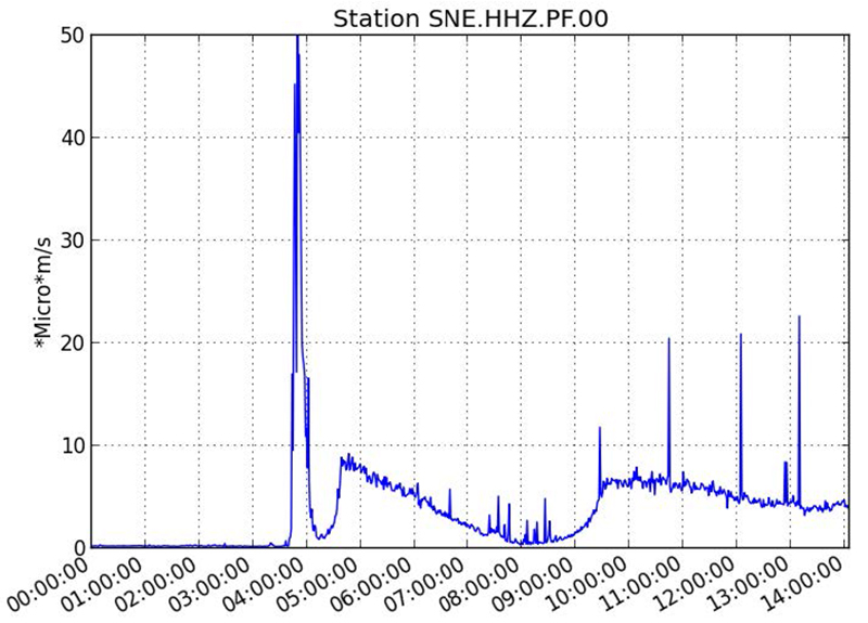
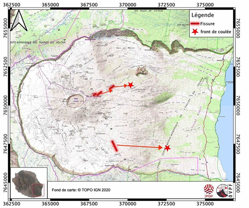
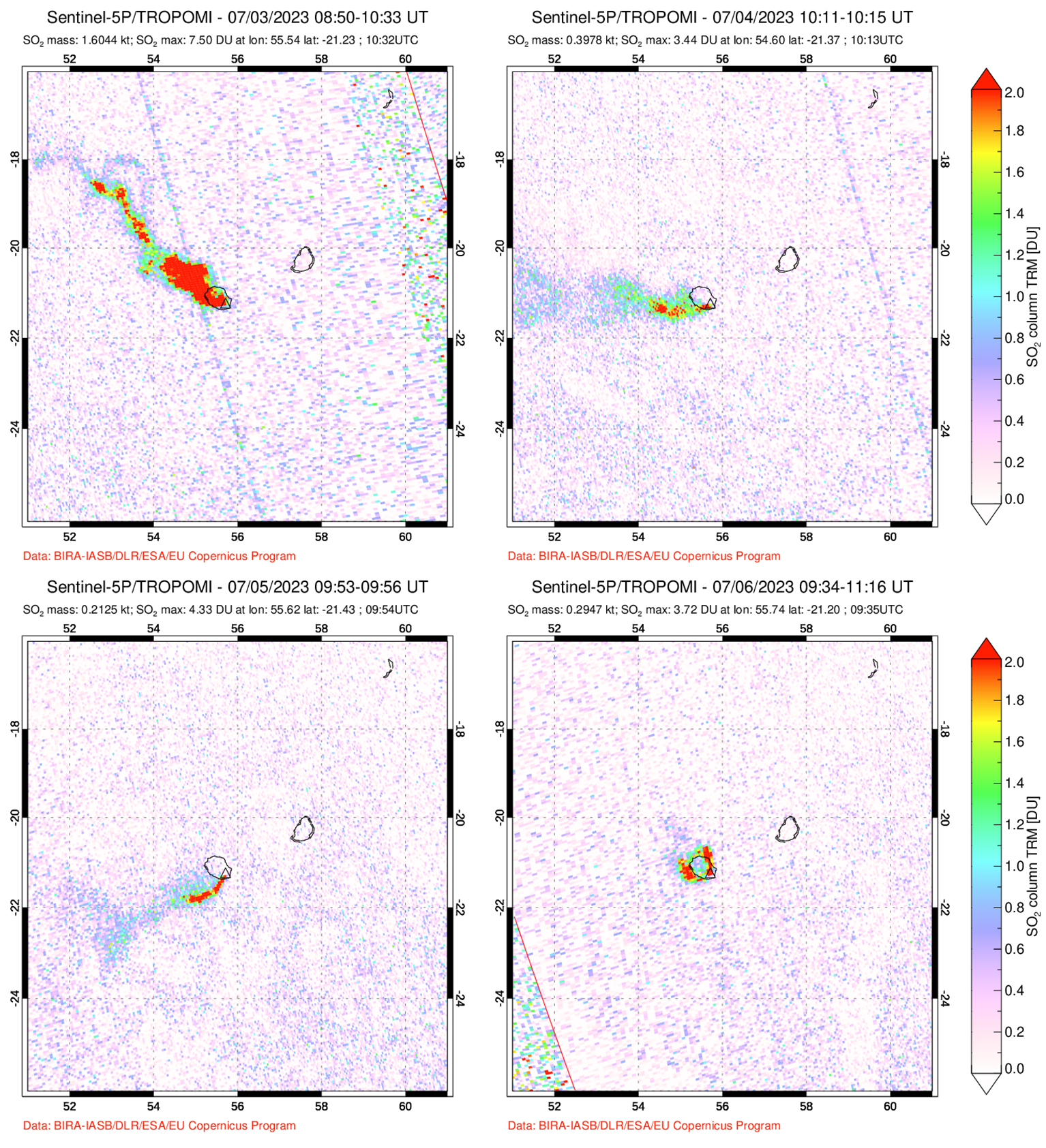
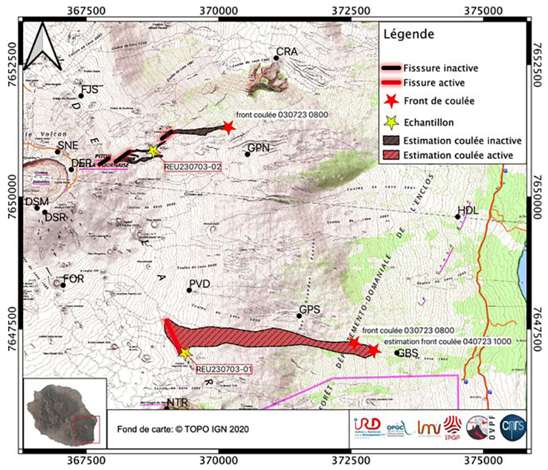
A seismic crisis began at 0736 on 2 July, which included an earthquake swarm and rapid deformation (figure 233). Volcanic tremor began at 0830, indicating the arrival of magma at the surface, and fissures opened on the E flank at around 0830 and 1230, and on the SE flank around 1750 inside the Enclos Fouqué caldera (figure 234). Lava flows from the two initial fissures moved ENE. The fissure on the SE flank was about 500 m long, trended NNW-SSE, and produced lava flows that traveled E. During the earthquake swarm, 578 shallow VT-type earthquakes were recorded below the S and N border of the Dolomieu crater. Seismicity then continued for several days, mainly below the summit crater; 1,754, 232, 70, 18, 33, and 12 shallow VT-type events were recorded on 2, 3, 4, 5, 6, and 7 July, respectively. There were 33 deep earthquakes detected below the E flank on 2 July after the onset of the eruption. Sulfur dioxide flux measured on 2 July was 10-20,000 tons/day (t/d) and then declined the following days to less than 1,000 t/d. During 3-6 July sulfur dioxide plumes of variable intensity were detected by the TROPOMI data using Sentinel-5P satellite images (figure 235). OVPF recommended a change in the Alert Level to 2-1, the lowest of two sub-levels in “Alert 2: ongoing eruption” (inside the Enclos Fouqué caldera) at 0850 on 2 July; Alert 2 is the third level on a four-color eruption scale.
The SE flank fissure was the most active of the two fissure areas by 0430 on 3 July, with lava flows traveling further to the E than from the higher E-flank fissures. The effusion rate generally fluctuated between 7-27 cubic meters per second (m3/s), averaging 12 m3/s based on satellite data. Field teams made visual observations during 0800-1000 on 3 July and noted that several eruptive fissures had opened on the E flank in Piton Vouvoul. The front of the lava flow had moved about 2 km from the highest point of the first fissure before stopping. Active lava fountaining built several cones along the SE-flank fissure. The main lava flow from the SE-flank fissure continued to advance, reaching 650 m in elevation in an area about 2.4 km from the nearest road by 0940 (figure 236). At 1012 there was a sharp decline in volcanic tremor amplitude that remained at lower levels. During 3-4 July the effusion rate fluctuated between 5-20 m3/s based on satellite data, and the flow front advanced at a rate of roughly 40 meters per hour (m/h) based on webcam images (figure 237). By 1424 on 4 July the lava flow was about 3.5 km long based on satellite image analysis (figure 238). On the morning of 6 July, eruptive activity was concentrated at a single vent located to the SE of Enclos Fouqué around 1.7 km elevation, where a cone continued to form (figure 239).
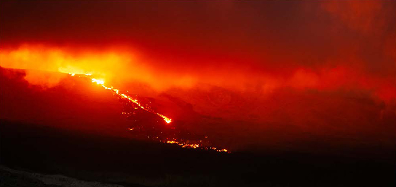 |
Figure 237. Photo of the active lava flow at Piton de la Fournaise moving SE of Enclos Fouqué at 2030 on 3 July 2023. Courtesy of OVPF-IPGP. |
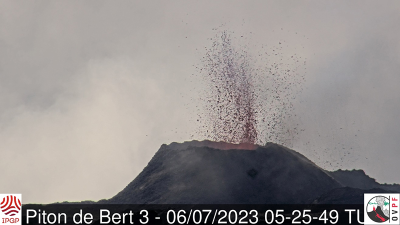 |
Figure 239. Webcam image of the active vent at Piton de la Fournaise located SE of Enclos Fouqué at 0925 on 6 July 2023 (local time). Courtesy of OVPF-IPGP. |
During an overflight on 7 July, a team from OVPF-IPGP determined that the lava flow had reached 1.8 km from the road but had not advanced since 5 July. The flow front did not extend any further to the E, but by 7 July active flows were moving through a lava tube. During 10-11 July flows traveled through tubes and were active at elevations about 1.3 km. Although clouds often prevented measurements, satellite analysis showed that lava flow rates fluctuated between 1.5-24 m3/s. The total volume of lava effused since the beginning of the eruption on 2 July was an estimated 5.5 million m3 by 11 July, based on the HOTVOLC and MIROVA systems.
On 12 July the top of the cone located SE from Enclos Fouqué partially filled. The flow front did not extend any further to the E and remained stalled 1.8 km from the road. Active flows traveled through lava tubes above 1.5 km elevation and continued to widen (increasing about 180 m since 7 July) and thicken, mainly affecting the N part of the flow and above 1.5 km elevation. Though clouds often prevented measurements, satellite analysis showed that effusion rates fluctuated between less than 1 and 13.5 m3/s. The total erupted volume since the start of the eruption was an estimated 6 ± 3 million m3 and by 22 July, the total volume of effused lava was an estimated 8.5 ± 3 million m3. The eruptive cone measured approximately 30 m high on the morning of 25 July. On 26 July the total volume of effused lava was an estimated 9.6 ± 3.4 million m3.
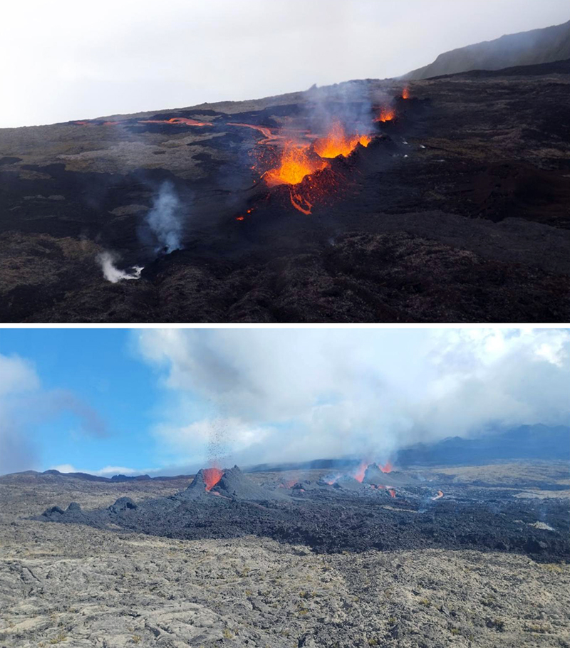
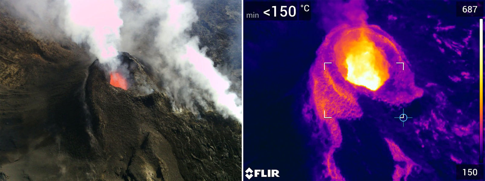
On 28 July the longest part of the flow remained stalled 1.8 km from the road and had solidified. An aerial overflight showed the active SE vent at Enclos Fouqué containing lava and accompanied by degassing (figure 240). By the end of July, there were 2,189 shallow VT-type earthquakes, 45 deep earthquakes, 111 LP-type earthquakes, and 235 rockfall events detected.
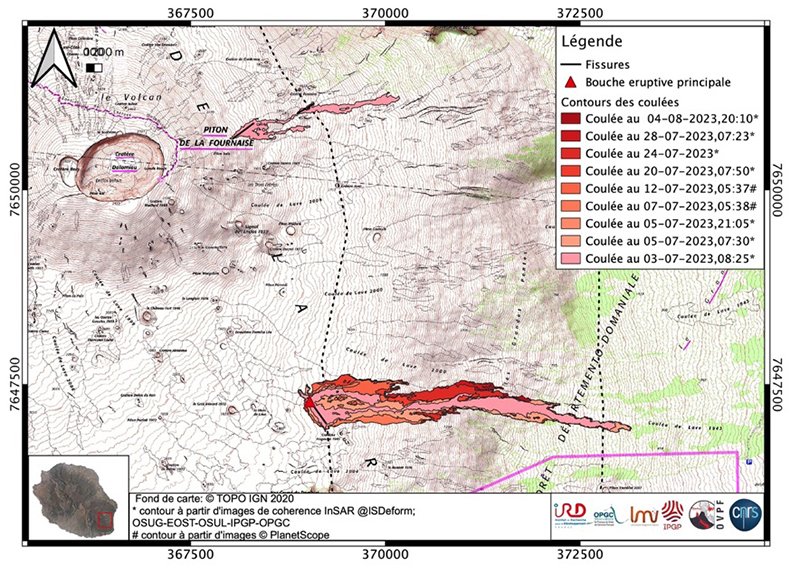
Activity during August consisted of incandescence, lava flows, and seismicity. There were 60 shallow VT-type earthquakes detected below the summit crater, mainly located beneath the E rim of the Dolomieu crater and 330 rockfall events, a majority of which occurred inside the Dolomieu crater, along the cliffs of the East River, and around the active lava flows. During 2-3 August lava flows were visibly active and traveled mainly through tubes; incandescence from breakout flows were also occasionally visible in semi-clear views. These flows originated at distances 1.2-2.5 km from the eruptive cone and the lowest active flow zone was observed from the Piton des Cascades webcam at 1 km elevation. OVPF reported that the eruption ended at 0500 on 10 August as the amplitude of the volcanic tremor (an indicator of lava and gas emissions) had declined the previous week. According to IPGP, there was an estimated 11.7 ± 4 million m3 erupted on the surface as of 10 August (figure 241). An earthquake was felt by some residents on the island, mainly in the Salazie area at 2031 on 11 August.
Geological Summary. Piton de la Fournaise is a massive basaltic shield volcano on the French island of Réunion in the western Indian Ocean. Much of its more than 530,000-year history overlapped with eruptions of the deeply dissected Piton des Neiges shield volcano to the NW. Three scarps formed at about 250,000, 65,000, and less than 5,000 years ago by progressive eastward slumping, leaving caldera-sized embayments open to the E and SE. Numerous pyroclastic cones are present on the floor of the scarps and their outer flanks. Most recorded eruptions have originated from the summit and flanks of Dolomieu, a 400-m-high lava shield that has grown within the youngest scarp, which is about 9 km wide and about 13 km from the western wall to the ocean on the E side. More than 150 eruptions, most of which have produced fluid basaltic lava flows, have occurred since the 17th century. Only six eruptions, in 1708, 1774, 1776, 1800, 1977, and 1986, have originated from fissures outside the scarps.
Information Contacts: Observatoire Volcanologique du Piton de la Fournaise, Institut de Physique du Globe de Paris, 14 route nationale 3, 27 ème km, 97418 La Plaine des Cafres, La Réunion, France (URL: http://www.ipgp.fr/fr); MIROVA (Middle InfraRed Observation of Volcanic Activity), a collaborative project between the Universities of Turin and Florence (Italy) supported by the Centre for Volcanic Risk of the Italian Civil Protection Department (URL: http://www.mirovaweb.it/); Global Sulfur Dioxide Monitoring Page, Atmospheric Chemistry and Dynamics Laboratory, NASA Goddard Space Flight Center (NASA/GSFC), 8800 Greenbelt Road, Goddard, Maryland, USA (URL: https://so2.gsfc.nasa.gov/).


