Report on Aira (Japan) — October 1975

Natural Science Event Bulletin, vol. 1, no. 1 (October 1975)
Managing Editor: David Squires.
Aira (Japan) Typical explosive eruptions
Please cite this report as:
Global Volcanism Program, 1975. Report on Aira (Japan) (Squires, D., ed.). Natural Science Event Bulletin, 1:1. Smithsonian Institution. https://doi.org/10.5479/si.GVP.NSEB197510-282080
Aira
Japan
31.5772°N, 130.6589°E; summit elev. 1117 m
All times are local (unless otherwise noted)
During the summer of 1975 Sakura-jima was normally active. There were 16 explosions in September (figure 1). The highest eruption cloud reached a few thousand meters altitude.
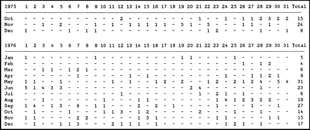 |
Figure 1. Summary table of explosions from Minami-dake crater at Sakura-jima, October 1975-December 1976. Data courtesy of JMA. [October 1975-May 1976 data were added, and errors in the June 1976-December 1976 data have been corrected from the originally published material.] |
Geological Summary. The Aira caldera in the northern half of Kagoshima Bay contains the post-caldera Sakurajima volcano, one of Japan's most active. Eruption of the voluminous Ito pyroclastic flow accompanied formation of the 17 x 23 km caldera about 22,000 years ago. The smaller Wakamiko caldera was formed during the early Holocene in the NE corner of the caldera, along with several post-caldera cones. The construction of Sakurajima began about 13,000 years ago on the southern rim and built an island that was joined to the Osumi Peninsula during the major explosive and effusive eruption of 1914. Activity at the Kitadake summit cone ended about 4,850 years ago, after which eruptions took place at Minamidake. Frequent eruptions since the 8th century have deposited ash on the city of Kagoshima, located across Kagoshima Bay only 8 km from the summit. The largest recorded eruption took place during 1471-76.
Information Contacts: JMA, Tokyo.