Report on Pacaya (Guatemala) — February 1976
Natural Science Event Bulletin, vol. 1, no. 5 (February 1976)
Managing Editor: David Squires.
Pacaya (Guatemala) Black steam cloud on 4 February; summit observations
Please cite this report as:
Global Volcanism Program, 1976. Report on Pacaya (Guatemala) (Squires, D., ed.). Natural Science Event Bulletin, 1:5. Smithsonian Institution. https://doi.org/10.5479/si.GVP.NSEB197602-342110
Pacaya
Guatemala
14.382°N, 90.601°W; summit elev. 2569 m
All times are local (unless otherwise noted)
"Pacaya, inactive since the October 1975 lava flow, resumed activity for at least 1 day prior to the 4 February earthquake. Black steam clouds from MacKenney Crater were seen in Guatemala City. A group camped at Pacaya on the morning of the 4 February earthquake reported that a black steam cloud was discharged from MacKenney Crater immediately after the event. Eruptions continued until sunrise. Primarily ash and steam with very few small blocks were discharged. At sunrise the eruptions ceased and Pacaya remained quiet until sunset when similar activity resumed. A group from Dartmouth College and IGN visited Pacaya on 16 February. There were no eruptions, but earth tremors of several seconds duration were felt during the 18 hours that the party was on the summit. Gas condensate samples were collected from a fumarole with a temperature of 138°C on the rim of MacKenney Crater.
"The summit crater of Pacaya was cut by at least seven steaming fractures that described a radial pattern. These fractures had been noted on visits to the summit in November 1975 and January 1976. A thermal infrared map was made of the W flank of Pacaya on the early morning of 18 February from a station near El Patrocinio. A large zone approximately 100 m square, at an elevation of 2,250 m, contained apparent surface temperatures 10° above ambient with a maximum apparent surface temperature of 40° above ambient. This zone bears watching as the possible locus of a future lava flow. An earth tremor of 10 seconds duration was felt while making the thermal map at 0620. At 0903 a dark cloud was erupted from MacKenney Crater. Six more similar eruptions took place in the next hour before the summit was obscured by clouds. Despite the absence of a favorable wind direction, ash from the eruptions fell near El Patrocinio, 2,200 m from the vent. The eruption clouds rose approximately 500 m above the summit and rocks were heard cascading down the slopes."
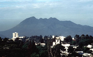
Geological Summary. Eruptions from Pacaya are frequently visible from Guatemala City, the nation's capital. This complex basaltic volcano was constructed just outside the southern topographic rim of the 14 x 16 km Pleistocene Amatitlán caldera. A cluster of dacitic lava domes occupies the southern caldera floor. The post-caldera Pacaya massif includes the older Pacaya Viejo and Cerro Grande stratovolcanoes and the currently active Mackenney stratovolcano. Collapse of Pacaya Viejo between 600 and 1,500 years ago produced a debris-avalanche deposit that extends 25 km onto the Pacific coastal plain and left an arcuate scarp inside which the modern Pacaya volcano (Mackenney cone) grew. The NW-flank Cerro Chino crater was last active in the 19th century. During the past several decades, activity has consisted of frequent Strombolian eruptions with intermittent lava flow extrusion that has partially filled in the caldera moat and covered the flanks of Mackenney cone, punctuated by occasional larger explosive eruptions that partially destroy the summit.
Information Contacts: Sam Bonis, IGN; Richard Birnie and Bradley Dean, Dartmouth College.

