Report on Soufriere Guadeloupe (France) — July 1976
Natural Science Event Bulletin, vol. 1, no. 10 (July 1976)
Managing Editor: David Squires.
Soufriere Guadeloupe (France) Additional details about 8 July phreatic explosion; summary of activity during 21 July-25 August 1976
Please cite this report as:
Global Volcanism Program, 1976. Report on Soufriere Guadeloupe (France) (Squires, D., ed.). Natural Science Event Bulletin, 1:10. Smithsonian Institution. https://doi.org/10.5479/si.GVP.NSEB197607-360060
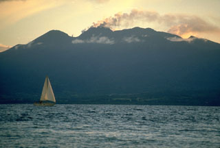
Soufriere Guadeloupe
France
16.044°N, 61.664°W; summit elev. 1467 m
All times are local (unless otherwise noted)
Since March 1976 a great number of volcanic earthquakes have been registered by the seismic array of the Observatory of St. Claude, Guadeloupe. The earthquakes numbered about 607 in March, 747 in April, 611 in May, and 668 in June. Most foci were distributed between 2 and 6 km under the volcano, along a NW-SE axis. Many earthquakes were felt by people living near Soufrière. The maximum magnitude was 3.8.
On 8 July at 0856, the volcano threw out a column of fine sand and dust, plunging the surrounding regions into darkness for 40 minutes. This fine volcanic material settled over the W side of the mountain and extended to the towns of Basse-Terre and Vieux-Habitants, on the W coast of Guadeloupe 8 km away. The thickness of this grey tephra was very irregular because of the influence of winds: about 8 cm near the summit to 1 or 2 cm near Basse-Terre. This eruption was followed by steam and gases rising from a new fracture 400 m long on the SE flank of the cone. A little avalanche (800 m long) of mud and rocks from this fracture accompanied the eruption.
Since 8 July the pressure of the gases has decreased and the temperature has remained around 96°C, but the volcanic seismicity remains important (300 earthquakes registered 9-20 July). A group of scientists from IPG, Commissariat à l'Energie Atomique, and the Université de Paris Sud, is investigating this eruption. They concluded that the eruption is phreatic (like the eruptions in 1956, [1837-38], and 1797). The chemical composition of the volcanic sand is the same as that of 1956 and corresponds to the composition of the old material of the cone (SiO2 = 57.8%). No new magma was emitted during this eruption.
Addendum: Summary of eruptive and seismic activity 25 July-1 September. Earthquake hypocenters are given in kilometers below sea level unless otherwise noted. [Corrections and additions to this addendum supplied by J. Gautheyrou and LANL, originally printed in 1:11, have been incorporated here.]
25 July: Significant ash eruption.
09 August: Ash eruption, causing a small river to stop flowing for 24 hours. When flow resumed, the water was very muddy.
12 August: Powerful new ash eruption containing juvenile material [but see 1:12]. Evacuation of 72,000 persons began (figure 3); evacuation was completed 15 August.
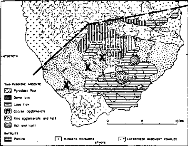 |
Figure 3. Geologic map of Soufrière Guadeloupe volcano, after Catalog of Active Volcanoes of the World. Heights are in meters. The area below the dashed line is the section of Basse-Terre that was evacuated due to the possibility of a major eruption. The crosses indicate the locations of the USGS dry-tilt stations at Savane à Mulets (closest to the summit), Parnasse, and Bonne Terre (farthest from the summit). |
16 August: Very fine ash erupted from the fissure that opened 8 July. At 1730 a magnitude 4.6 earthquake with a hypocenter at about 2.5 km occurred, followed by 20 minutes of very frequent tremors that saturated a detector 8 km from the volcano for about 10 minutes.
17 August: Approximately 900 earthquakes were recorded in the 24 hours after the beginning of the 16 August seismic crisis. Depths of focus ranged from 1 to 3 km. An earthquakes registering about 4.0 occurred at 2315. An expedition to the volcano noted weaker gas pressure and a new 5-cm ashfall at the foot of the dome. Mudflows were forming from the new ash because of heavy rainfall. At 1700 the principal vent was puffing and a plume of fine particles was being emitted from the N fracture. The 1,500 residents of Vieux-Fort were evacuated. Microprobe analysis of earlier 1976 ejecta indicated andesitic magma at ~900°C.
18 August: The volcano was quiet enough to allow the temporary return of farmers. Earthquake foci were about 2.5 km deep.
19 August: About 1 mm of fine dust was found on the dome. 95% of the erupted material was <0.2 mm in diameter; the coarsest was 2 mm mushroom-colored glass. Dust made breathing difficult in a sector from Basse Terre to Bouillante. Earthquake hypocenters were at about 2.5 km depth.
20 August: There was a steady, non-explosive emission of steam rising to <300 m.
21 August: A major increase in the SO2 content of gases sampled was followed in about 8 hours by 11 minutes of harmonic tremor, beginning at 2326. All instruments were saturated for the first 3 minutes. An ash eruption, probably coinciding with the harmonic tremor, left a few centimeters of ash at the base of the dome, 3 mm 1/3 of the way up the mountain, and ~1 mm on the S coast. An expedition the following day discovered that the SE fracture had been widened and that blocks up to 1 m across had been blown 400 m to the old rim (L'Echelle). Hypocenters of recorded earthquakes were at or above sea level.
22 August: More than 100 of the 156 recorded earthquakes occurred by 0800. Activity then declined. Emission of steam and other gases occurred from vents south of the summit dome (Gouffre Tarissan, Pont Chinois and Gouffre Dupuy). Rain caused a mudflow in the Galion River.
23 August: An increase in radon emission during the afternoon predicted an increase in activity; minor dust emissions were reported.
24 August: A period of major seismic activity began at 0256 with a M 4.1 event centered 2 km under the W side of Soufrière. More than 1,000 earthquakes were recorded by 1530 (figure 4), two of which were felt in Pointe-a-Pitre, 20 km away. Intervals between events and earthquake amplitudes were both decreasing by afternoon. Radon percentage in the gas increased with increased seismicity. SO2 had returned to normal. Minor dust emission continued. 50 cm of dust, largely composed of fresh glass, was present at the S side of the summit dome (Gouffre Tarissan).
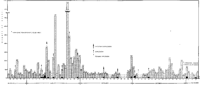 |
Figure 4. Number of recorded seismic events per day at Soufrière Guadeloupe, 21 July-7 November 1976. |
25 August: The volume of ash erupted increased significantly and the eruption clouds were much darker after 1530. Ash emission was from the S and E vents (Gouffre Tarissan and Dent de l'Est). Study of the tephra erupted since the 24 August seismic crisis indicates both an increase in the percentage of fresh glass and an increase (to 2 mm) in the size of the glass shards. The percentage of chemical weathering products in the ejecta also increased. Between 2000 on 25 August and 0600 on 26 August, 120 earthquakes were recorded, some having hypocenters as shallow as 300 m above sea level. Gas analyses showed lower percentages of SO2, SO3, and H2S than for previous days. Radon again increased during seismic crises.
26 August: A 100-200 m column of ash was erupted continuously from Gouffre Tarissan (the main vent at the top of the dome) and from the upper end of the SE fracture. The remainder of the SE fracture emitted steam that was almost entirely of meteoric origin. The 26 August ash was dry, and therefore paler than the wet ash of 25 August. The ash was blown W; 2 cm were deposited on the W slopes of the dome and 1-2 mm on the W coast towns. Approximately 50% of the ash was juvenile glass [but see 1:12]. Ash emission ended in the morning. The magmatic component of the emitted gases was low.
27 August: Considerable steam was emitted, along with some dust. Fresh glass was erupted from Pont Chinois and the N fracture. SO2 and H2S were present in small amounts in the volcanic gases.
28 August: An expedition to the dome found 1 m of very fine dust around Gouffre Tarissan and a few centimeters of dust along the flanks of the dome. One block a few centimeters across was found near the top of the dome.
29 August: A 10 µrad inflation of the volcano had occurred since 28 August. Eruptive activity was limited to minor ash emission. Earthquake hypocenters 27-29 August were all shallower than 3 km; all but four were shallower than 2 km, and one was above sea level. No ash emission occurred 28-29 August. The gases analyzed were almost entirely of meteoric origin.
30 August: A small eruption occurred at 1015 from the main vent, accompanied by 22 minutes of harmonic tremor, the first 13 minutes of which saturated the instruments. A party of seven volcanologists was showered by blocks up to 1 m across; four were injured but none seriously. 209 earthquakes were recorded. The ash, analyzed by the LANL, is 95% alteration products (fine-grained clayey material and pyrite) and 5% rock and crystal fragments (andesite, plagioclase, and pyroxene). Volatile content was high, and there was no fresh glass.
31 August: Large volumes of steam with some admixed ash erupted from all of the previously active vents. The steam cloud from the main vent reached 2,000 m altitude in the evening due to light winds. 6-8 cm of juvenile ash (80% glass), which flocculated into 5 mm flakes as it fell, was deposited near the main vent, as were blocks up to 20 cm across that were torn from the vent and blown up to 400 m away. A new earthquake swarm began at 1035 and lasted for 6-8 hours, accounting for most of the 249 seismic events recorded 31 August. A total of 5989 earthquakes were recorded in August, 43 of which were felt.
1 September: Strong steam emission continued, producing cauliflower clouds that reached a height of 300 m before being blown W. A grayish-brown haze of very fine ash was falling on the top quarter of the volcano.
Geological Summary. La Soufrière de la Guadeloupe volcano occupies the southern end of Basse-Terre, the western half of the island of Guadeloupe. Construction of the Grand Découverte volcano about 200,000 years ago was followed a Plinian eruption and caldera formation about 100,000 years later, and then by construction of the Carmichaël volcano within the caldera. Two episodes of edifice collapse and associated large debris avalanches formed the Carmichaël and Amic craters about 11,500 and 3,100 years ago, respectively. The present volcano subsequently grew within the Amic crater. The summit consists of a flat-topped lava dome, and several other domes occur on the southern flanks. Six phreatic explosive eruptions since 1690 opened radial fractures across the summit lava dome. The phreatic eruptions in 1976-77 caused severe economic disruption when Basse-Terre, the island's capital city immediately below the volcano, was evacuated.
Information Contacts: J. Dorel, IPG, Paris; J. Gautheyrou, ORSTOM; J. Tomblin, UWI; M. Feuillard, Lab. de Physique du Globe; LANL.