Report on Arenal (Costa Rica) — January 1977

Natural Science Event Bulletin, vol. 2, no. 1 (January 1977)
Managing Editor: David Squires.
Arenal (Costa Rica) Active block flow overrides 1974 flows and buries monitoring stations
Please cite this report as:
Global Volcanism Program, 1977. Report on Arenal (Costa Rica) (Squires, D., ed.). Natural Science Event Bulletin, 2:1. Smithsonian Institution. https://doi.org/10.5479/si.GVP.NSEB197701-345033
Arenal
Costa Rica
10.463°N, 84.703°W; summit elev. 1670 m
All times are local (unless otherwise noted)
Arenal volcano, observed 11 January, 1977, remained as active as it was 12-22 October 1976 (figures 2 and 3). The only change is that an active block flow is now moving from the summit crater (D) towards the SW, overriding 1974 flows. On 29 January, it had descended to about 1,000 m elevation, burying seismic and dry tilt stations recently installed on the rim of the lower crater (A; figure 4).
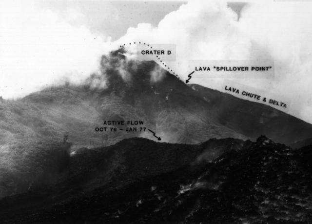 |
Figure 2. Photograph of the N side of Arenal, showing the still-growing N lava field. Crater D (summit crater) has greatly enlarged since the begining of current eruptions (1968). Photo taken by W.G. Melson, October 1976. |
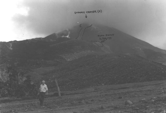 |
Figure 3. Photograph of the SW side of Arenal, showing the now inactive Crater A and an approximate outline of the active SW-moving lava flow as of 29 January 1977. Photo taken by W.G. Melson, 11 January 1977. |
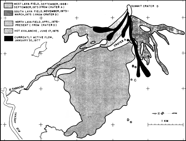 |
Figure 4. Preliminary sketch map of the N, S, and W lava fields at Arenal, showing lava flows and the hot avalanche deposit of 17 June 1975. Dates are approximate. Tilt stations B, C, and D are shown by circles. Grid markings refer to the 1000 Meter Transverse Mercator Grid, Zone 16, Clarke 1866 Spheroid (Fortuna, Costa Rica 1:50,000 Quadrangle). Adapted from a map prepared by Hugo T. Tims and provided by Jorge Umaña, Instituto Costarricense de Electricidad. Tilt station A, not shown in the map, is about 100 m S of the center of Crater A. Courtesy of W.G. Melson. |
Geological Summary. Conical Volcán Arenal is the youngest stratovolcano in Costa Rica and one of its most active. The 1670-m-high andesitic volcano towers above the eastern shores of Lake Arenal, which has been enlarged by a hydroelectric project. Arenal lies along a volcanic chain that has migrated to the NW from the late-Pleistocene Los Perdidos lava domes through the Pleistocene-to-Holocene Chato volcano, which contains a 500-m-wide, lake-filled summit crater. The earliest known eruptions of Arenal took place about 7000 years ago, and it was active concurrently with Cerro Chato until the activity of Chato ended about 3500 years ago. Growth of Arenal has been characterized by periodic major explosive eruptions at several-hundred-year intervals and periods of lava effusion that armor the cone. An eruptive period that began with a major explosive eruption in 1968 ended in December 2010; continuous explosive activity accompanied by slow lava effusion and the occasional emission of pyroclastic flows characterized the eruption from vents at the summit and on the upper western flank.
Information Contacts: W. Melson, SI.