Report on Ukinrek Maars (United States) — March 1977
Natural Science Event Bulletin, vol. 2, no. 3 (March 1977)
Managing Editor: David Squires.
Ukinrek Maars (United States) Explosions send ash plume above 6 km height
Please cite this report as:
Global Volcanism Program, 1977. Report on Ukinrek Maars (United States) (Squires, D., ed.). Natural Science Event Bulletin, 2:3. Smithsonian Institution. https://doi.org/10.5479/si.GVP.NSEB197703-312131
Ukinrek Maars
United States
57.8344°N, 156.5203°W; summit elev. 91 m
All times are local (unless otherwise noted)
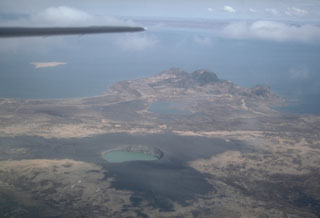
On 30 March, explosions were reported at 1500 and 1720 from a vent 13 km [but see 2:4] NW of Peulik volcano. The latter explosion was viewed from close range from a Wien Air Alaska plane. Its crew reported that the dense, ash-laden eruption cloud rose higher than 6,000 m. Peulik, an 1,844-m stratovolcano with a dacite lava dome, last erupted in 1852. It is surrounded by several small olivine andesite scoria cones.
Geological Summary. Ukinrek Maars are two explosion craters that were created in an area without previous volcanic activity during a 10-day phreatomagmatic eruption March-April 1977. The basaltic maars were erupted through glacial deposits in the Bering Sea lowlands 1.5 km S of Becharof Lake and 12 km W of Peulik volcano; their location is related to the regional Bruin Bay fault. The elliptical West Maar, which was the first to form, is 105 x 170 m and 35 m deep. The other maar, 600 m to the east, is 300 m wide and 70 m deep. Both maars are now filled by crater lakes; the eastern lake encircles a 49-m-high lava dome that was emplaced at the end of the eruption. Base surges were directed primarily to the NW. Juvenile material from the Ukinrek eruptions was of mantle-derived olivine basaltic composition. The dacitic Gas Rocks lava domes, of Quaternary age, are located on the shores of Becharof Lake, 3 km N of Ukinrek maars and were the site of a phreatic eruption about 2,300 years ago.
Information Contacts: T. Miller, USGS, Anchorage.