Report on Soufriere Guadeloupe (France) — March 1977
Natural Science Event Bulletin, vol. 2, no. 3 (March 1977)
Managing Editor: David Squires.
Soufriere Guadeloupe (France) Earthquake rate decreases to 1 per day
Please cite this report as:
Global Volcanism Program, 1977. Report on Soufriere Guadeloupe (France) (Squires, D., ed.). Natural Science Event Bulletin, 2:3. Smithsonian Institution. https://doi.org/10.5479/si.GVP.NSEB197703-360060
Soufriere Guadeloupe
France
16.044°N, 61.664°W; summit elev. 1467 m
All times are local (unless otherwise noted)
"Daily recorded earthquakes at Soufrière had decreased from a maximum of 1257 on 24 August 1976 to one per day by the first week in March 1977 (figure 5). Figure 6 shows the seismic energy released during 10-day periods. Total energy release from 1 November 1975 through February 1977 was ~1.9 x 10¹⁸ ergs. Figure 7 shows the number of earthquakes in various magnitude ranges. The largest magnitude was 4.2 (4.9 by NEIS determination) on 16 August 1976.
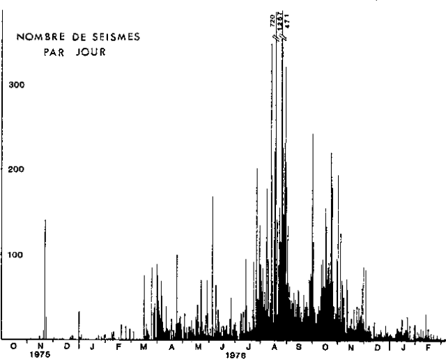 |
Figure 5. Daily recorded earthquakes at Soufrière Guadeloupe, October 1975-March 1977. Courtesy of J. Dorel. |
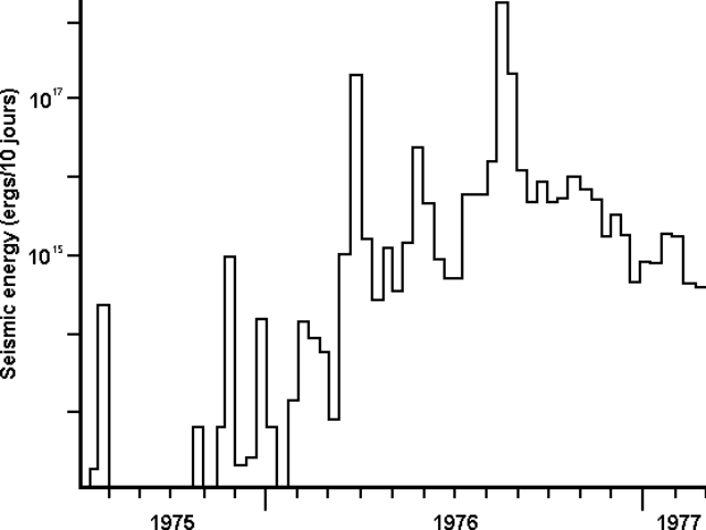 |
Figure 6. Seismic energy release in ergs for 10-day periods at Soufrière Guadeloupe, July 1975-February 1977. Courtesy of J. Dorel. |
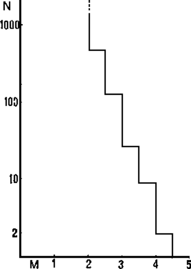 |
Figure 7. Number of recorded earthquakes at Soufrière Guadeloupe in magnitude increments of 0.5, late 1975-February 1977. Courtesy of J. Dorel. |
"Hypocenter determination has been made for about 350 events. Figure 8 shows NW-SE and NE-SW vertical sections (under the volcano) onto which the foci are projected. Different symbols are used for different time series, but the variation with time of the depths of quakes during the crisis is not meaningful. Mean depth is about 2.5 km.
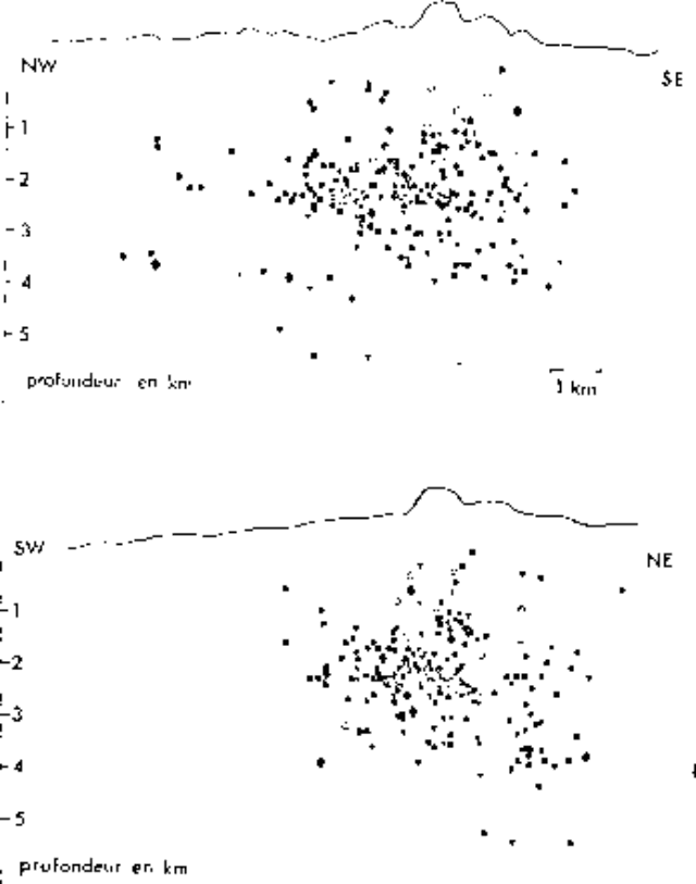 |
Figure 8. Cross-sections at Soufrière Guadeloupe running NW-SE (top) and NE-SW (bottom) showing earthquake hypocenters. Courtesy of J. Dorel. |
"Volcanic tremor, the duration of which varied from a few minutes to a few tens of minutes, has been recorded by the seismographs. The tremor events correspond to such important surface manifestations as steam, solid ejecta, and fracture opening. With its 16,000 earthquakes and a total energy release greater than 1018 ergs, the La Soufrière crisis is the most important in the Carribean region in the past 40 years."
Geological Summary. La Soufrière de la Guadeloupe volcano occupies the southern end of Basse-Terre, the western half of the island of Guadeloupe. Construction of the Grand Découverte volcano about 200,000 years ago was followed a Plinian eruption and caldera formation about 100,000 years later, and then by construction of the Carmichaël volcano within the caldera. Two episodes of edifice collapse and associated large debris avalanches formed the Carmichaël and Amic craters about 11,500 and 3,100 years ago, respectively. The present volcano subsequently grew within the Amic crater. The summit consists of a flat-topped lava dome, and several other domes occur on the southern flanks. Six phreatic explosive eruptions since 1690 opened radial fractures across the summit lava dome. The phreatic eruptions in 1976-77 caused severe economic disruption when Basse-Terre, the island's capital city immediately below the volcano, was evacuated.
Information Contacts: J. Dorel, Univ. Pierre et Marie Curie, Paris.