Report on Karthala (Comoros) — April 1977
Natural Science Event Bulletin, vol. 2, no. 4 (April 1977)
Managing Editor: David Squires.
Karthala (Comoros) Lava extrusion during 5-10 April eruption destroys three villages
Please cite this report as:
Global Volcanism Program, 1977. Report on Karthala (Comoros) (Squires, D., ed.). Natural Science Event Bulletin, 2:4. Smithsonian Institution. https://doi.org/10.5479/si.GVP.NSEB197704-233010
Karthala
Comoros
11.75°S, 43.38°E; summit elev. 2361 m
All times are local (unless otherwise noted)
The eruption began at about noon on 5 April from a SW flank vent, after a series of local tremors during the morning. Basaltic lava was extruded, which divided into two flows ~300 m wide and 3-15 m thick, separated by several hundred meters. The flows reconverged downslope and reached the sea on 6 April. Strong earthquakes were felt on the SE flank on 8 April, but were not accompanied by surface activity. Lava extrusion had ended on 10 April, although heavy fuming from nearby fissures continued as late as 17 April, preventing close approach to the vent, which was surrounded by up to 6 m of lapilli. No casualties were reported, but 4,000 people were evacuated and three villages damaged or destroyed.
Further Reference. Krafft, M., 1982, L'Eruption volcanique du Kartala en Avril 1977 (Grande Comore, Ocean Indien): C.R. Acad. Sci. Paris, serie II, v. 294, p. 753-758.
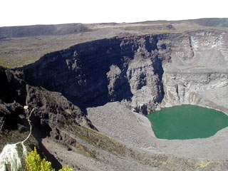
Geological Summary. The southernmost and largest of the two shield volcanoes forming Grand Comore Island (also known as Ngazidja Island), Karthala contains a 3 x 4 km summit caldera generated by repeated collapse. Elongated rift zones extend to the NNW and SE from the summit of the Hawaiian-style basaltic shield, which has an asymmetrical profile that is steeper to the S. The lower SE rift zone forms the Massif du Badjini, a peninsula at the SE tip of the island. Historical eruptions have modified the morphology of the compound, irregular summit caldera. More than twenty eruptions have been recorded since the 19th century from the summit caldera and vents on the N and S flanks. Many lava flows have reached the sea on both sides of the island. An 1860 lava flow from the summit caldera traveled ~13 km to the NW, reaching the W coast to the N of the capital city of Moroni.
Information Contacts: P. de Saint Ours, St. Maurice, France; G. Beauchamp, OFDA.

