Report on Toya (Japan) — August 1977
Natural Science Event Bulletin, vol. 2, no. 8 (August 1977)
Managing Editor: David Squires.
Toya (Japan) Major eruption on 7 August from a new vent
Please cite this report as:
Global Volcanism Program, 1977. Report on Toya (Japan) (Squires, D., ed.). Natural Science Event Bulletin, 2:8. Smithsonian Institution. https://doi.org/10.5479/si.GVP.NSEB197708-285030
Toya
Japan
42.544°N, 140.839°E; summit elev. 733 m
All times are local (unless otherwise noted)
A major eruption began at 0912 on 7 August 1977 from a new vent [on the SE slope of] Ko-Usu dome (figure 1), after [32] hours of premonitory seismicity. About [0.08] km3 of hypersthene dacite tephra has been ejected, in eruption columns that rose to 10 km or more on four occasions (figure 2). Ashfalls forced the evacuation of about 20,000 tourists and 7,000 residents from nearby towns, and caused serious crop damage, particularly N of the volcano (figures 3 and 4). Table 1 is a summary of the eruption.
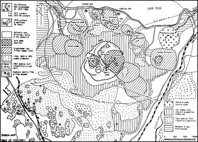 |
Figure 1. Geologic map of Usu showing vent locations for the eruption that began in August 1977. From Katsui and others, 1985. |
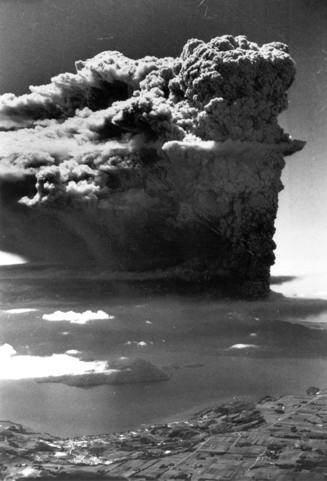 |
Figure 2. Ash-laden cloud from Usu at 0950 on 7 August 1977, 38 minutes after the eruption began. View approximately to the S. Photo by The Hokkaido Shinbun, courtesy of Yoshio Katsui. |
 |
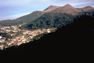
Figure 3. Usu volcano on 12 August 1977 looking SE across Lake Toya with the town of Toyako-Spa in the foreground. O-Usu (left) and Ko-Usu (right) lava domes lie within the Usu somma. The first three major explosive eruptions 7-9 August originated from vents behind Ko-Usu in this view; the fourth major eruption on 9 August occurred from a vent in front of O-Usu. Trees on the upper slopes were completely stripped of leaves by volcanic ejecta. Photo by Lee Siebert. |
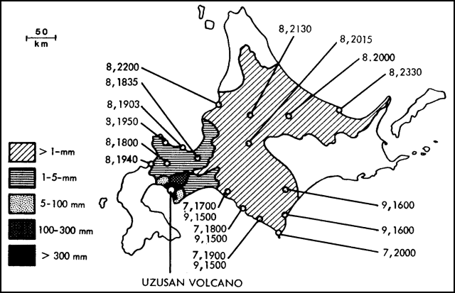 |
Figure 4. Map showing distribution of Usu's ash on the island of Hokkaido. Open circles are sampling localities. The associated numbers refer to the date and time of first appearance(s) at each locality of [pumice from] explosions on 7, 8, and 9 August 1977. Courtesy of JMA. |
Table 1. Summary of explosions from Usu, 7-14 August 1977. Vent numbers correspond to those shown in figure 1. Cloud heights (in km) are approximate. Adapted from Katsui and others (1978).
| Date | Time | Vent | Cloud Height | Ashfall Azimuth | Remarks |
| 07 Aug 1977 | 0912-1140 | 1 | 12 | S 60 E | Up to 30 cm of ash and breccia fell 4 km away. Airplane windows were cracked by tephra at 3,600 m altitude. Lightning accompanied the eruption cloud. "White smoke." |
| 07 Aug 1977 | 1331 | 1 | 2 | -- | -- |
| 07 Aug 1977 | 1620 | 1 | 1.5 | -- | -- |
| 07 Aug 1977 | 1822 | 1 | 1.5 | -- | -- |
| 08 Aug 1977 | 1335-1410 | 2 | -- | -- | -- |
| 08 Aug 1977 | 1537-1800 | 2 | 10 | N 40 W | Ash reached Asahigawa, 180 km NE. Pumice up to 20 cm diameter fell 3 km away. |
| 08 Aug 1977 | 1900 | 2 | -- | -- | -- |
| 08-09 Aug 1977 | 2340-0215 | 3 | 10? | N 45 W | Incandescent material rose several hundred meters. |
| 09 Aug 1977 | 0530-0730 | 3 | 6? | N 10 E | Ash reached the Sea of Okhotsk, about 75 km N. |
| 09 Aug 1977 | 0815-0825 | 3 | 1.5 | -- | -- |
| 09 Aug 1977 | 0855-0905 | 3 | 1.5 | -- | -- |
| 09 Aug 1977 | 0908-0925 | 3 | 1 | -- | -- |
| 09 Aug 1977 | 1020-1105 | 4 | 4 | N 75 E | -- |
| 09 Aug 1977 | 1120-1420 | 4 | 9 | S 65 E | -- |
| 12 Aug 1977 | 0812-0900 | 3 | 2.5 | N 35 W | "Black smoke." |
| 13-14 Aug 1977 | 2237-0155 | 3 | 4? | N 70 E | Two centimeters of pumice nearby; eruption accompanied by lightning. |
Earthquake frequency exceeded 100 events/hour during the premonitory swarm, then ranged between 60 and [120]/hour until the afternoon of 16 August, when a decline to 40/hour occurred. [Seismicity declined suddenly when explosions occurred (figure 5).] By 24 August, event frequency had declined further but magnitudes had increased to a maximum of 4, resulting in an increase in total energy release. Hypocenters were 1-2 km beneath the [summit].
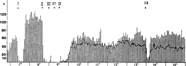 |
Figure 5. Hourly seismicity at Usu from the night of 6-7 August to 15 August 1977. Decreases in seismicity accompanied major explosive episodes, indicated by small triangles. Courtesy of JMA. |
Uplift and fissuring were observed on 12 August between Ko-Usu and O-Usu domes. Ground temperatures in this area were elevated to 33°C from the normal 24°C. Usu last erupted 23 June 1944-30 September 1945, producing Showa-Shinzan dome [at the E foot of the volcano].
Reference. Katsui, Y., Komuro, H., and Uda, T., 1985, Development of faults and growth of Usu-shinzan cryptodome in 1977-1982 at Usu volcano, north Japan: Journal of the Faculty of Science, Hokkaido University, ser. IV: Geology and Mineralogy, v. 21, no. 3, p. 339-362.
Geological Summary. Usuzan, one of Hokkaido's most well-known volcanoes, is a small stratovolcano located astride the southern topographic rim of the 110,000-year-old Toya caldera. The center of the 10-km-wide, lake-filled caldera contains Nakajima, a group of forested Pleistocene andesitic lava domes. The summit of the basaltic-to-andesitic edifice of Usu is cut by a somma formed about 20-30,000 years ago when collapse of the volcano produced a debris avalanche that reached the sea. Dacitic domes erupted along two NW-SE-trending lines fill and flank the summit caldera. Three of these domes, O-Usu, Ko-Usu and Showashinzan, along with seven crypto-domes, were erupted during historical time. The 1663 eruption of Usu was one of the largest in Hokkaido during historical time. The war-time growth of Showashinzan from 1943-45 was painstakingly documented by the local postmaster, who created the first detailed record of growth of a lava dome.
Information Contacts: T. Tiba, National Science Museum, Tokyo; L. Siebert, SI; J. Bloom, U.S. Embassy, Tokyo.