Report on Kilauea (United States) — September 1977

Natural Science Event Bulletin, vol. 2, no. 9 (September 1977)
Managing Editor: David Squires.
Kilauea (United States) Fissure eruption begins on the East Rift near Kalalua Crater
Please cite this report as:
Global Volcanism Program, 1977. Report on Kilauea (United States) (Squires, D., ed.). Natural Science Event Bulletin, 2:9. Smithsonian Institution. https://doi.org/10.5479/si.GVP.NSEB197709-332010
Kilauea
United States
19.421°N, 155.287°W; summit elev. 1222 m
All times are local (unless otherwise noted)
A substantial eruption on the E rift began from fissures near Kalalua Crater (figure 1) on 13 September, after about 24 hours of premonitory activity.
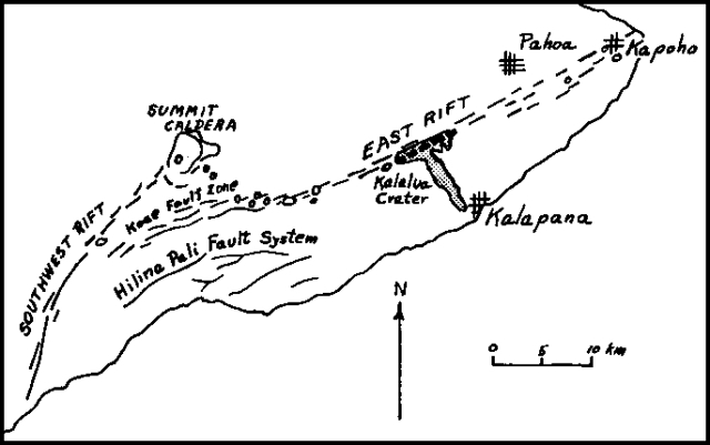 |
Figure 1. Sketch map outlining the September lava flows (stipple pattern) and various features of Kīlauea. Open circles are craters. Courtesy of Robert Tilling. |
Field observations suggest interesting changes in lava composition during the course of the eruption. Lava erupted during the first three phases and about the first 1.5 days of the fourth phase apparently consisted of differentiated material containing plagioclase and pyroxene phenocrysts. This was succeeded on the 27th by more typical Hawaiian tholeiite basalt containing olivine phenocrysts.
Geological Summary. Kilauea overlaps the E flank of the massive Mauna Loa shield volcano in the island of Hawaii. Eruptions are prominent in Polynesian legends; written documentation since 1820 records frequent summit and flank lava flow eruptions interspersed with periods of long-term lava lake activity at Halemaumau crater in the summit caldera until 1924. The 3 x 5 km caldera was formed in several stages about 1,500 years ago and during the 18th century; eruptions have also originated from the lengthy East and Southwest rift zones, which extend to the ocean in both directions. About 90% of the surface of the basaltic shield volcano is formed of lava flows less than about 1,100 years old; 70% of the surface is younger than 600 years. The long-term eruption from the East rift zone between 1983 and 2018 produced lava flows covering more than 100 km2, destroyed hundreds of houses, and added new coastline.
Information Contacts: R. Tilling, USGS, Reston, VA; G. Eaton, HVO; R. Fiske, SI.