Report on Westdahl (United States) — January 1978
Scientific Event Alert Network Bulletin, vol. 3, no. 1 (January 1978)
Managing Editor: David Squires.
Westdahl (United States) Large new explosive eruption
Please cite this report as:
Global Volcanism Program, 1978. Report on Westdahl (United States) (Squires, D., ed.). Scientific Event Alert Network Bulletin, 3:1. Smithsonian Institution. https://doi.org/10.5479/si.GVP.SEAN197801-311340
Westdahl
United States
54.516°N, 164.65°W; summit elev. 1563 m
All times are local (unless otherwise noted)
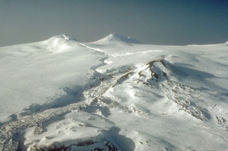
The USCG reported on 6 February that ash, accompanied by a sulfur odor, was falling on a station located at the foot of Westdahl. Lightning was observed above the summit, accompanied by thunder and rumbling. The summit is not visible from the Coast Guard station and cloud cover has prevented direct aerial observation of the group of volcanoes which includes stratovolcanoes Westdahl and Pogromni, active in historical time. However, Reeve Aleutian Airways personnel report an ash cloud rising to 8-10 km altitude, including some large blocks visible above the 3-km cloud layer. Satellite images returned 5 February show a well-developed ash cloud, but it has not yet been possible to pinpoint the eruption start time [see 3:9].
Geological Summary. Westdahl is a broad glacier-covered volcano occupying the SW end of Unimak Island. Two peaks protrude from the summit plateau, and a new crater formed in 1978 cuts the summit icecap. The volcano has a somewhat of a shield-like morphology and forms one of the largest volcanoes of the Aleutian Islands. The sharp-topped, conical Pogromni stratovolcano, 6 km N, rises several hundred meters higher than Westdahl, but is moderately glacially dissected and presumably older. Many satellitic cones of postglacial age are located along a NW-SE line cutting across the summit of Westdahl. Some of the historical eruptions attributed to the eroded Pogromni may have originated instead from Westdahl (Miller et al. 1998). The first historical eruption occurred in 1795. An 8-km-long fissure extending east from the summit produced explosive eruptions and lava flows in 1991.
Information Contacts: T. Miller, USGS, Anchorage.