Report on Whakaari/White Island (New Zealand) — April 1978

Scientific Event Alert Network Bulletin, vol. 3, no. 4 (April 1978)
Managing Editor: David Squires.
Whakaari/White Island (New Zealand) Eruptive and seismic activity decline after formation of new crater
Please cite this report as:
Global Volcanism Program, 1978. Report on Whakaari/White Island (New Zealand) (Squires, D., ed.). Scientific Event Alert Network Bulletin, 3:4. Smithsonian Institution. https://doi.org/10.5479/si.GVP.SEAN197804-241040
Whakaari/White Island
New Zealand
37.52°S, 177.18°E; summit elev. 294 m
All times are local (unless otherwise noted)
White Island was visited on 21 March and inspected from the air on 5 April. The new collapse crater, provisionally named Gibrus Crater, is the largest new topographic feature to form on White Island since 1914 (average diameter is 325 m, depth about 100 m; figure 4). Its approximate volume was 6.7 x 10⁶ m3, more than 3x that of adjacent Christmas Crater.
Steam rising to 400 m obscured the new crater during most of the 21 March visit, but cleared briefly revealing steam vents, including the "active vent", which ejected ash and blocks during the 16 March overflight. A pair of 20 m-diameter vents near the NW wall had built small ash cones (figure 5). Hot gas (> 550°C) was emitted at high velocity from a new fumarole 50 m NNE of Noisy Nellie and temperatures of 370°C and 250°C were recorded in H2S-rich gas from strongly active fumaroles on Donald Mound. Strong fumarolic activity deposited sulfur on the S wall of Christmas Crater.
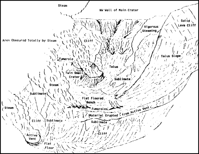 |
Figure 5. Sketch by B. J. Scott showing the interior of Gibrus Crater on March, looking W from the E crater rim. |
Numerous impact craters containing accessory blocks up to 0.6 m in diameter were found on 21 March up to 500 m from the new crater. Tephra thickness exceeded 85 cm near the crater rim. All tephra had been deposited as airfall.
Large black eruption clouds were observed at 0950 on 30 March (rising 3,000-4,500 m) and during the early morning of 4 April (visible from Tauranga, ~100 km away). However, no major new ashfall was seen on 5 April, nor were there any apparent changes in crater morphology (figures 6 and 7). Steam from Gibrus and Christmas craters rose 750 m, but other fumarolic activity had declined.
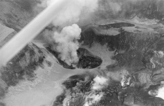 |
Figure 6. Oblique airphoto taken by J. Perrin on 11 March 1977, looking W, showing much of the W portion of White Island's main crater before the formation of the new (Gibrus) crater in March 1978. Compare with April photograph (figure 7). Courtesy of B.J. Scott, NZGS. |
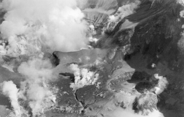 |
Figure 7. Oblique airphoto taken by E. F. Lloyd on 5 April 1978, looking WNW. The large vigorously steaming Gibrus Crater is behind the shallower, gently steaming Christmas Crater. |
The formation of Gibrus Crater between 2 and 16 March was not observed, but numerous local earthquakes were recorded during this period. Larger events are tabulated below (table 2).
[J.H. Latter has corrected elements of this table and has rewritten the following paragraph based on more up-to-date information.]
Table 2. Larger seismic events 2-17 March 1978. Earthquake type is Minakami A-type (>3 Hz); type B, low-frequency (less than 1.75 Hz); C type, intermediate in frequency between A and B types. Type E indicates explosion event. J.H. Latter has corrected elements of this table.
| Date | Time | Magnitude (ML) | Type | Remarks |
| 02 Mar 1978 | 0125 | ~3.1 | A | -- |
| 04 Mar 1978 | 0316 | 2.4 | E | -- |
| 05 Mar 1978 | 0112 | 2.6 | A | Two events. |
| 05 Mar 1978 | 0355 | 2.4 | E | -- |
| 05 Mar 1978 | 1743 | 2.4 | C | -- |
| 06 Mar 1978 | 2006 | 2.7? | A | -- |
| 08 Mar 1978 | 0302 | 2.4 | E | -- |
| 08 Mar 1978 | 1805 | 2.5? | C | -- |
| 15 Mar 1978 | 1700 | 2.4 | C | -- |
| 16 Mar 1978 | 0320 | 2.3 | C | -- |
| 17 Mar 1978 | 2111 | 2.6 | C | Largest C-type shock during the period. |
| 17 Mar 1978 | 2136 | 2.4 | C | -- |
| 17 Mar 1978 | 2146 | 2.5 | E | Probably the largest explosion earthquake during the period. |
[Volcanic tremor was conspicuous until 17 March. It was strong on 8 and 17 March, and ended immediately after the explosion earthquake at 2146 on 17 March.]
Geological Summary. The uninhabited Whakaari/White Island is the 2 x 2.4 km emergent summit of a 16 x 18 km submarine volcano in the Bay of Plenty about 50 km offshore of North Island. The island consists of two overlapping andesitic-to-dacitic stratovolcanoes. The SE side of the crater is open at sea level, with the recent activity centered about 1 km from the shore close to the rear crater wall. Volckner Rocks, sea stacks that are remnants of a lava dome, lie 5 km NW. Descriptions of volcanism since 1826 have included intermittent moderate phreatic, phreatomagmatic, and Strombolian eruptions; activity there also forms a prominent part of Maori legends. The formation of many new vents during the 19th and 20th centuries caused rapid changes in crater floor topography. Collapse of the crater wall in 1914 produced a debris avalanche that buried buildings and workers at a sulfur-mining project. Explosive activity in December 2019 took place while tourists were present, resulting in many fatalities. The official government name Whakaari/White Island is a combination of the full Maori name of Te Puia o Whakaari ("The Dramatic Volcano") and White Island (referencing the constant steam plume) given by Captain James Cook in 1769.
Information Contacts: B. Scott, E. Lloyd, and I. Nairn, NZGS, Rotorua; J. Latter, DSIR, Wellington.