Report on Fernandina (Ecuador) — August 1978
Scientific Event Alert Network Bulletin, vol. 3, no. 8 (August 1978)
Managing Editor: David Squires.
Fernandina (Ecuador) Earthquake appears to have triggered new eruption
Please cite this report as:
Global Volcanism Program, 1978. Report on Fernandina (Ecuador) (Squires, D., ed.). Scientific Event Alert Network Bulletin, 3:8. Smithsonian Institution. https://doi.org/10.5479/si.GVP.SEAN197808-353010
Fernandina
Ecuador
0.37°S, 91.55°W; summit elev. 1476 m
All times are local (unless otherwise noted)
A new eruption began on 8 August and had apparently ended on 19 August when the last observers left the island. An earthquake (mb 4.5) at 0955 was located by USGS/NEIS 43 km NE of Fernandina caldera (easily within hypocenter location error for an event of this size at Fernandina) and appears to have triggered the eruption. One hour later an eruptive cloud was first noticed over the volcano and at 1230-1240 cloud heights of 4,500 and 6,000 m were independently estimated from distant parts of the archipelago. At this time (1231) a NOAA infrared satellite image recorded an irregular cloud roughly 55 km in diameter with its SE boundary over Fernandina. One hour later the cloud was still 55 km in maximum dimension, but had become wedge shaped with its apex over Fernandina and measured 27 km across at its WNW end. After another hour, at 1432, the plume had narrowed to 13 km some 46 km from its apex, and the next hourly image (1533) showed only the indistinct hint of a plume. That night, glow was observed over Fernandina several times and lightning was seen for 1/2 hour. On 9 August a large cloud remained over Fernandina, growing during the afternoon, but it has not been recognized on satellite imagery.
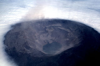
A group including Tui DeRoy Moore and Howard Snell reached the caldera rim on 10 August as the eruption entered its third full day. They observed smoking vents along a fissure on the NW bench of the caldera, roughly 300 m below the rim [see also 3:9]. This bench, isolated by a prehistoric collapse of the elliptical 4 x 6 km caldera, is symmetrically opposite the SE bench that has been the site of eruptions in 1972, 1973, and 1977. The SE end of the caldera also experienced maximum subsidence (350 m) in the major caldera collapse of 1968, while the NW end was unaffected both then and in the 10 years since. Scoria was recognized down to 200 m elevation on the NW flank and Pele's hair reached the NW coast of the island, 12 km from the caldera rim.
Remaining on the rim for nearly 3 days, the group observed intermittent fountaining along the 1-km fissure feeding lava to the caldera lake 500 m below and 2 km to the SE. One strong tremor was felt and rockfalls on the caldera walls were nearly continuous. Activity had declined when they left on 13 August, but another group, including Dee Boersma and Bob Tindle, reached the volcano on the night of 16 August and observed glow over the caldera. They climbed to the rim on the 18th and observed fountaining to 100 m from vents at the back of the bench, some 400 m NW of the vents active on 10-13 August [but see 3:9]. Fresh spatter was on caldera walls 200 m above the vents, and lava was flowing to the steaming lake. Activity declined in the early morning of 19 August and only vapor issued from the vents as the group left the rim. Neither vapor nor glow were seen over the volcano on 20 and 21 August, and no more recent reports are available.
Geological Summary. Fernandina, the most active of Galápagos volcanoes and the one closest to the Galápagos mantle plume, is a basaltic shield volcano with a deep 5 x 6.5 km summit caldera. The volcano displays the classic "overturned soup bowl" profile of Galápagos shield volcanoes. Its caldera is elongated in a NW-SE direction and formed during several episodes of collapse. Circumferential fissures surround the caldera and were instrumental in growth of the volcano. Reporting has been poor in this uninhabited western end of the archipelago, and even a 1981 eruption was not witnessed at the time. In 1968 the caldera floor dropped 350 m following a major explosive eruption. Subsequent eruptions, mostly from vents located on or near the caldera boundary faults, have produced lava flows inside the caldera as well as those in 1995 that reached the coast from a SW-flank vent. Collapse of a nearly 1 km3 section of the east caldera wall during an eruption in 1988 produced a debris-avalanche deposit that covered much of the caldera floor and absorbed the caldera lake.
Information Contacts: H. Hoeck, R. Tindle, and H. Snell, CDRS, Galápagos; T. Moore, Academy Bay, Galápagos; A. Kreuger, NOAA; D. Boersma, Univ. of Washington; USGS/NEIS, Denver, CO.

