Report on Marapi (Indonesia) — October 1978
Scientific Event Alert Network Bulletin, vol. 3, no. 10 (October 1978)
Managing Editor: David Squires.
Marapi (Indonesia) Ash emission from summit area
Please cite this report as:
Global Volcanism Program, 1978. Report on Marapi (Indonesia) (Squires, D., ed.). Scientific Event Alert Network Bulletin, 3:10. Smithsonian Institution. https://doi.org/10.5479/si.GVP.SEAN197810-261140
Marapi
Indonesia
0.38°S, 100.474°E; summit elev. 2885 m
All times are local (unless otherwise noted)
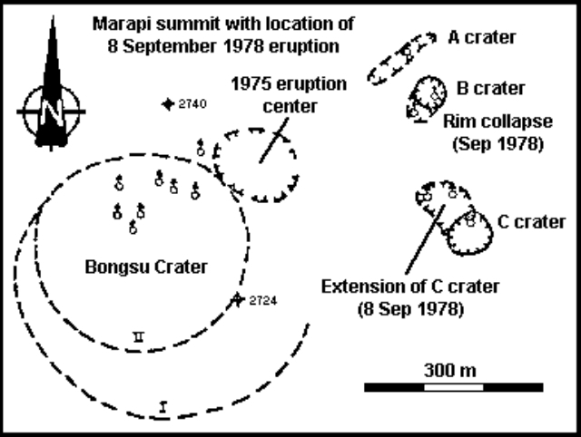
At 1830 on 8 September Marapi ejected a thick blackish-gray cauliflower-shaped cloud to 1500 m above the crater, accompanied by glow and a roaring noise. Andesitic ash and lapilli fell on a 30 km2 area. This explosion was preceded by a number of smaller ones that produced 300-500-m-high clouds. Fumarolic emissions, rising as much as 700 m and containing some ash, were continuing as of 18 September. No seismicity was felt in villages around the volcano. The activity originated from the lateral extension of a small, pre-existing, summit area crater (figure 1), ~300 m E of the central crater. When visited on 13 September the active crater was an elongate feature 95 m long, 50 m wide, and ~50 m deep.
Geological Summary. Gunung Marapi, not to be confused with the better-known Merapi volcano on Java, is Sumatra's most active volcano. This massive complex stratovolcano rises 2,000 m above the Bukittinggi Plain in the Padang Highlands. A broad summit contains multiple partially overlapping summit craters constructed within the small 1.4-km-wide Bancah caldera. The summit craters are located along an ENE-WSW line, with volcanism migrating to the west. More than 50 eruptions, typically consisting of small-to-moderate explosive activity, have been recorded since the end of the 18th century; no lava flows outside the summit craters have been reported in historical time.
Information Contacts: F. Suparban Mitrohartono, VSI.


