Report on Ardoukoba (Djibouti) — November 1978
Scientific Event Alert Network Bulletin, vol. 3, no. 11 (November 1978)
Managing Editor: David Squires.
Ardoukoba (Djibouti) Basaltic lava flows; first eruption in as much as 3,000 years
Please cite this report as:
Global Volcanism Program, 1978. Report on Ardoukoba (Djibouti) (Squires, D., ed.). Scientific Event Alert Network Bulletin, 3:11. Smithsonian Institution. https://doi.org/10.5479/si.GVP.SEAN197811-221126
Ardoukoba
Djibouti
11.58°N, 42.47°E; summit elev. 298 m
All times are local (unless otherwise noted)
The crew of a French observation aircraft saw an eruption early 8 November in a virtually uninhabited area SE of Lake Assal. On the preceding day a series of weak earthquakes was felt in the city of Djibouti and two larger shallow events were located by the U. S. Geological Survey's National Earthquake Information Center (USGS/NEIC). The first, mb 5.2, occurred on 7 November at 2006 (felt as a sharp shock in Djibouti) and the second, mb 5.0, on 8 November at 0808. Hypocenters calculated by the USGS for these events are 8 and 17 km WSW of the eruption, or well within the location error for events in this region.
Two basaltic lava flows were reportedly extruded: one flow traveled ~1 km to the SE, the other ~0.5 km to the NW. Lava effusion rates reached an estimated maximum of 1,000 m3/minute [but see 0.5 x 10⁶ m3/hour below]. Ash clouds rose ~300 m and larger pyroclastics ~70 m. The eruption formed a crater ~30 m in diameter and built a cone ~100 m high.
Activity began to decline 14 November and within two days only steaming was visible. As of 22 November, some vapor emission continued from subsidiary vents. No casualties or damage were reported.
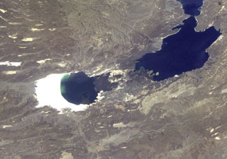
The Ardoukoba (Asal) Rift in Djibouti (figure 1), trending NW from the Red Sea, contains a broad area of youthful fissure vents between Lake Asal and the Ghoubbat al Kharab gulf. Although no previous eruptions have been reported in the area in historic time, the most recent lava flows are substantially younger than sediments 14C dated at 5,300 B.P., and are thought to be younger than 3,000 B.P. Eruptions are also mentioned in local legends (Delibrias and others, 1975).
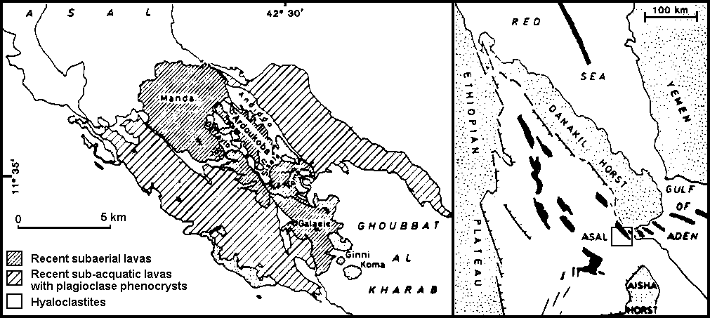 |
Figure 1. Map of the Ardoukoba Rift area (left), indicated by index map (right), showing rock types and volcanic centers. Latitudes and longitudes were added by SEAN and are approximate. Both maps after Delibrias and others (1975). |
Reference. Delibrias, G., Marinelli, G., and Stieltjes, L., 1975, Spreading rate of the Asal Rift, in Pilger, A. and Rosler, A. (eds.), Afar Depression of Ethiopia: Inter-Union Commission on Geodynamics Scientific Report No. 14: E. Schweitzerbart'sche Verlagsbuchhandlung, Stuttgart.
Geological Summary. The Ardoukôba (Asal) Rift in Djibouti, trending NW from the Red Sea, contains a broad area of youthful fissure vents between Lake Asal and the Ghoubbat al Kharab gulf. It is subaerially exposed over 12 km between these two bodies of water and contains numerous basaltic cinder and spatter cones. The silicic centers of Eger Alayta and Asa Aleyta, on the N and S sides, are remnants of a Pleistocene silicic center that has been disrupted and spread apart. Magma-water interaction has produced tuff cones, some of which form islands or are breached by the sea. The most recent lava flows are younger than lake sediments deposited 5,300 years ago. These lavas were thought to have been erupted during the past 3,000 years (Delibrias et al., 1975). The fissure erupted in 1978, producing a small cinder cone and lava flows that covered part of the rift floor near the Red Sea.
Information Contacts: W. Clarke, U.S. Embassy, Djibouti; M. Krafft, Cernay, France; USGS/NEIC.