Report on Toya (Japan) — November 1978
Scientific Event Alert Network Bulletin, vol. 3, no. 11 (November 1978)
Managing Editor: David Squires.
Toya (Japan) Lahar kills three nearby; explosions decline
Please cite this report as:
Global Volcanism Program, 1978. Report on Toya (Japan) (Squires, D., ed.). Scientific Event Alert Network Bulletin, 3:11. Smithsonian Institution. https://doi.org/10.5479/si.GVP.SEAN197811-285030
Toya
Japan
42.544°N, 140.839°E; summit elev. 733 m
All times are local (unless otherwise noted)
A lahar flowed through the town of Toyako-spa (at Usu's NW foot) on 24 October, killing three persons, destroying 16 houses, and damaging 20 others. However, the number of summit area explosions declined to three in October (one each on the 5th, 18th, and 27th) after one or more had been recorded on 16 days in September. The 5 October explosion originated from Gin-numa crater, active since August, but a new 30-m-diameter vent (labeled N in figure 13) opened less than 100 m to the NE on 18 October and was the source of the explosions on the 18th and 27th.
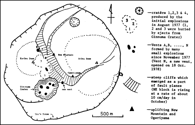 |
Figure 13. Map of the Usu summit area, late October 1978. Locations were surveyed by the Katsui group of the University of Hokkaido and JMA The figure was adapted by Manabu Komiya from the Katsui Group report. |
I. Yokoyama reported that both the average number of earthquakes per day and the rate of cryptodome uplift increased slightly in October, continuing a trend that began the preceding month.
Geological Summary. Usuzan, one of Hokkaido's most well-known volcanoes, is a small stratovolcano located astride the southern topographic rim of the 110,000-year-old Toya caldera. The center of the 10-km-wide, lake-filled caldera contains Nakajima, a group of forested Pleistocene andesitic lava domes. The summit of the basaltic-to-andesitic edifice of Usu is cut by a somma formed about 20-30,000 years ago when collapse of the volcano produced a debris avalanche that reached the sea. Dacitic domes erupted along two NW-SE-trending lines fill and flank the summit caldera. Three of these domes, O-Usu, Ko-Usu and Showashinzan, along with seven crypto-domes, were erupted during historical time. The 1663 eruption of Usu was one of the largest in Hokkaido during historical time. The war-time growth of Showashinzan from 1943-45 was painstakingly documented by the local postmaster, who created the first detailed record of growth of a lava dome.
Information Contacts: JMA, Tokyo; I. Yokoyama, Hokkaido Univ.