Report on Karkar (Papua New Guinea) — January 1979
Scientific Event Alert Network Bulletin, vol. 4, no. 1 (January 1979)
Managing Editor: David Squires.
Karkar (Papua New Guinea) 10-day ash eruption, after 6 months of seismicity
Please cite this report as:
Global Volcanism Program, 1979. Report on Karkar (Papua New Guinea) (Squires, D., ed.). Scientific Event Alert Network Bulletin, 4:1. Smithsonian Institution. https://doi.org/10.5479/si.GVP.SEAN197901-251030
Karkar
Papua New Guinea
4.647°S, 145.976°E; summit elev. 1839 m
All times are local (unless otherwise noted)
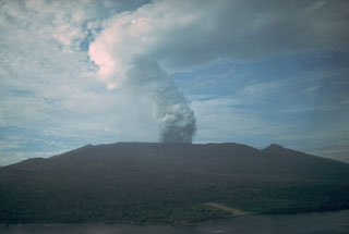
"An eruption commenced from a new crater late 12 or early 13 January. The crater was on the floor of the inner caldera, SE of Bagiai cone, very close to but not precisely at the previously reported incandescent zone. Thick but fairly light-colored ash clouds were erupted continuously for about 10 days from the new crater, which was 100-150 m in diameter. Eruptive activity ceased about 22-23 January and a voluminous column of white vapour has been emitted from the new crater since then, although possible very light ash content was reported on the 30th. A temporary observation post (established in early September and occupied continuously since then in expectation of the eruption) was in operation throughout the month, but observations have been severely hampered by heavy monsoon weather and the precise times of commencement and cessation are not known.
"The commencement of the eruption was not marked by any unusual events, audible or instrumental. Volcano-seismic activity continued at a moderately high level throughout January, although it was considerably weaker than the peak activity of October-November. The eruption was not marked by any distinctive volcano-seismic features. Periodic stronger and weaker phases of ash emission corresponded with banding on seismic records, similar to that previously reported. At times of stronger ash ejection, flashing arcs were often seen at a rate of several per second, but noises were not prominent.
"Heavy ashfall blanketed the upper levels of forest on Karkar Island, downwind from the volcano, but ashfall was light in inhabited and cultivated areas and there was no significant damage reported. Fouling of streams by ash has affected water supply in some villages."
Geological Summary. Karkar is a 19 x 25 km forest-covered island that is truncated by two nested summit calderas. The 5.5 km outer caldera was formed during one or more eruptions, the last of which occurred 9,000 years ago. The steep-walled 300-m-deep, 3.2 km diameter, inner caldera was formed sometime between 1,500 and 800 years ago. Cones are present on the N and S flanks of this basaltic-to-andesitic volcano; a linear array of small cones extends from the northern rim of the outer caldera nearly to the coast. Recorded eruptions date back to 1643 from Bagiai, a pyroclastic cone constructed within the inner caldera, the floor of which is covered by young, mostly unvegetated andesitic lava flows.
Information Contacts: C. McKee, RVO.

