Report on Toya (Japan) — February 1979
Scientific Event Alert Network Bulletin, vol. 4, no. 2 (February 1979)
Managing Editor: David Squires.
Toya (Japan) Cryptodome uplift rate continues decline; 2 year history summarized graphically
Please cite this report as:
Global Volcanism Program, 1979. Report on Toya (Japan) (Squires, D., ed.). Scientific Event Alert Network Bulletin, 4:2. Smithsonian Institution. https://doi.org/10.5479/si.GVP.SEAN197902-285030
Toya
Japan
42.544°N, 140.839°E; summit elev. 733 m
All times are local (unless otherwise noted)
No explosions occurred in January 1979. The average number of local earthquakes/day declined slightly, from 84 in December to 76 in January (figure 16), and the rate of cryptodome uplift also showed a small decrease. The ground deformation continued NW of the volcano, but stopped to the N, NE, and E (figure 17).
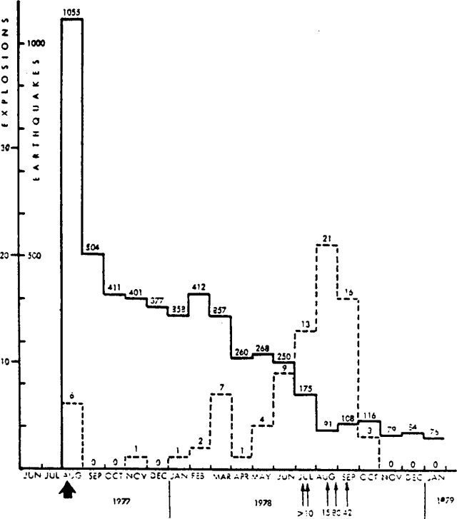 |
Figure 16. Monthly means of Usu's daily seismicity recorded by a seismograph 2.3 km N of Usu (solid line), and number of days per month in which explosions occurred (dashed line), June 1977-January 1979. The double arrow represents the major explosions of 7-14 August 1977 and the single arrows indicate the most important of the much smaller 1978 explosions. The number beneath each single arrow is the thickness of tephra, in mm, deposited at the foot of the volcano by that explosion (data from figures 11 and 12). Courtesy of JMA. |
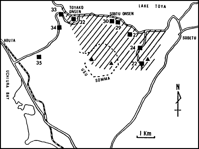 |
Figure 17. Map of Usu and vicinity, with the area affected by severe ground deformation shaded. Courtesy of JMA. |
Geological Summary. Usuzan, one of Hokkaido's most well-known volcanoes, is a small stratovolcano located astride the southern topographic rim of the 110,000-year-old Toya caldera. The center of the 10-km-wide, lake-filled caldera contains Nakajima, a group of forested Pleistocene andesitic lava domes. The summit of the basaltic-to-andesitic edifice of Usu is cut by a somma formed about 20-30,000 years ago when collapse of the volcano produced a debris avalanche that reached the sea. Dacitic domes erupted along two NW-SE-trending lines fill and flank the summit caldera. Three of these domes, O-Usu, Ko-Usu and Showashinzan, along with seven crypto-domes, were erupted during historical time. The 1663 eruption of Usu was one of the largest in Hokkaido during historical time. The war-time growth of Showashinzan from 1943-45 was painstakingly documented by the local postmaster, who created the first detailed record of growth of a lava dome.
Information Contacts: JMA, Tokyo.