Report on Westdahl (United States) — February 1979
Scientific Event Alert Network Bulletin, vol. 4, no. 2 (February 1979)
Managing Editor: David Squires.
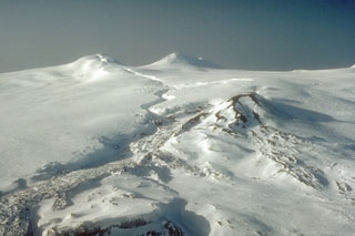
Westdahl (United States) 8-km cloud seen on satellite imagery
Please cite this report as:
Global Volcanism Program, 1979. Report on Westdahl (United States) (Squires, D., ed.). Scientific Event Alert Network Bulletin, 4:2. Smithsonian Institution. https://doi.org/10.5479/si.GVP.SEAN197902-311340
Westdahl
United States
54.516°N, 164.65°W; summit elev. 1563 m
All times are local (unless otherwise noted)
A cloud apparently erupted from Westdahl was present on NOAA weather satellite imagery for more than 30 hours on 8 and 9 February. The cloud was first observed on an infrared image at 0352 on 8 February, about 17 hours after the previous image, on which no eruption cloud could be seen. A cloud was present on successive images on the 8th at 0926 (visible and infrared) and on the 9th at 0842 and 1037 (infrared) but not at 1958 on the 9th or 0952 on the l0th. The cloud was no more than 50 km in longest dimension on any of the images, nor was it elongated into a typical volcanic plume.
The height of the cloud was calcuated separately from infrared and visual images taken at 0926 on 8 February. Analysis of the infrared image gives a temperature of -53°C at the top of the cloud, corresponding to an altitude of slightly more than 8 km. On the visual image, measurements of the shadow cast on the weather cloud deck by the volcanic cloud result in an estimated altitude of 7.7 ± 1 km.
No activity was reported from the USCG LORAN Station at Cape Sarichef, less than 25 km from Westdahl, nor was there any aircraft confirmation of the activity.
Geological Summary. Westdahl is a broad glacier-covered volcano occupying the SW end of Unimak Island. Two peaks protrude from the summit plateau, and a new crater formed in 1978 cuts the summit icecap. The volcano has a somewhat of a shield-like morphology and forms one of the largest volcanoes of the Aleutian Islands. The sharp-topped, conical Pogromni stratovolcano, 6 km N, rises several hundred meters higher than Westdahl, but is moderately glacially dissected and presumably older. Many satellitic cones of postglacial age are located along a NW-SE line cutting across the summit of Westdahl. Some of the historical eruptions attributed to the eroded Pogromni may have originated instead from Westdahl (Miller et al. 1998). The first historical eruption occurred in 1795. An 8-km-long fissure extending east from the summit produced explosive eruptions and lava flows in 1991.
Information Contacts: F. Parmenter, NOAA/NESS, Anchorage; J. Kienle, Univ. of Alaska; USCG LORAN Station, Unimak Island.