Report on Arenal (Costa Rica) — February 1979

Scientific Event Alert Network Bulletin, vol. 4, no. 2 (February 1979)
Managing Editor: David Squires.
Arenal (Costa Rica) Two years of tilt data summarized
Please cite this report as:
Global Volcanism Program, 1979. Report on Arenal (Costa Rica) (Squires, D., ed.). Scientific Event Alert Network Bulletin, 4:2. Smithsonian Institution. https://doi.org/10.5479/si.GVP.SEAN197902-345033
Arenal
Costa Rica
10.463°N, 84.703°W; summit elev. 1670 m
All times are local (unless otherwise noted)
In October 1976, four dry tilt stations were installed along a radial line on the W side of the volcano. Since then, these stations have been releveled at about 1-month intervals. Throughout the 2 years of measurement, Arenal has been emitting block lava flows from its summit crater, at largely unknown but widely ranging rates of emission. During this period each station has shown, on the average, continuing deflation. Figure 5 shows deflation along the approximately 40-m-long radial line at each station. As expected, stations closest to the volcano show the largest rate of deflation. Periods of rapid deflation in some cases correlate with times of high rates of lava emission.
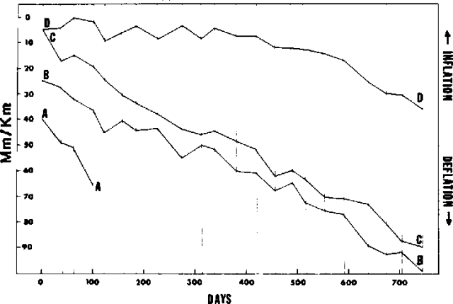 |
Figure 5. Inflation/deflation radial to Arenal's summit, in µrad, at tilt stations A, B, C, and D, from 19 October 1976 (day 0) to 3 November 1978. |
W. Melson notes that these data are consistent with a very shallow magma chamber 2 km below the surface, following the Mogi (1958) model of surface deformation over a spherical magma chamber and assuming maximum tilt at Station A. The extensive tilt measurements at Kīlauea show a quite different pattern than at Arenal. Specifically, deflation is extremely rapid, occurring over 12-hour to 6-month intervals, often accompanied by flank eruptions. At Arenal, more or less continuous deflation is accompanied by nearly continuous, long-term eruption of lava from the summit crater. At Hawaii, rates of lava emission are much higher than at Arenal, where basaltic andesite lavas (55% SiO2) contain about 50% phenocrysts and are clearly more viscous than the basalts of Hawaii. It seems reasonable to conclude that these different deflation behaviors are related directly to the different viscosities.
Access to Station A was blocked in February, 1977 by a new lava flow. Stations A, C, and D are tilt vectors oriented very close to, or on, the radial line. Station B is along a sharp ridge crest and only one component of tilt, along the ridge crest, (roughly on the radial line) can be measured.
The installation and relevelling were done by ICE topographers with advice from W. G. Melson and R. S. Fiske, in accordance with similar successful stations on Hawaii. Relevelling is done using a Wilde N3 level and precision stadia. The benchmarks at each station are in unconsolidated airfall, lahar, and avalanche deposits. Stability was obtained by driving 3 m-long, 2.5 cm-diameter steel rods into the ground. In most cases, it proved possible to drive these completely into the ground. The upper soil zones around each stake were excavated to about 1 m and filled with concrete. The top of each stake was then rounded, and between measurements is coated with grease and capped to prevent rusting.
Geological Summary. Conical Volcán Arenal is the youngest stratovolcano in Costa Rica and one of its most active. The 1670-m-high andesitic volcano towers above the eastern shores of Lake Arenal, which has been enlarged by a hydroelectric project. Arenal lies along a volcanic chain that has migrated to the NW from the late-Pleistocene Los Perdidos lava domes through the Pleistocene-to-Holocene Chato volcano, which contains a 500-m-wide, lake-filled summit crater. The earliest known eruptions of Arenal took place about 7000 years ago, and it was active concurrently with Cerro Chato until the activity of Chato ended about 3500 years ago. Growth of Arenal has been characterized by periodic major explosive eruptions at several-hundred-year intervals and periods of lava effusion that armor the cone. An eruptive period that began with a major explosive eruption in 1968 ended in December 2010; continuous explosive activity accompanied by slow lava effusion and the occasional emission of pyroclastic flows characterized the eruption from vents at the summit and on the upper western flank.
Information Contacts: W. Melson, SI; J. Umaña and E. Evans, ICE.