Report on Marapi (Indonesia) — May 1979
Scientific Event Alert Network Bulletin, vol. 4, no. 5 (May 1979)
Managing Editor: David Squires.
Marapi (Indonesia) Landslide, not eruption, caused fatalities on 30 April
Please cite this report as:
Global Volcanism Program, 1979. Report on Marapi (Indonesia) (Squires, D., ed.). Scientific Event Alert Network Bulletin, 4:5. Smithsonian Institution. https://doi.org/10.5479/si.GVP.SEAN197905-261140
Marapi
Indonesia
0.38°S, 100.474°E; summit elev. 2885 m
All times are local (unless otherwise noted)
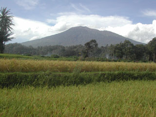
Press reports describing a tephra eruption of Marapi on 30 April were incorrect. About 300 mm of rainfall remobilized an old lahar and other volcanic material on Marapi's N and E flanks, producing several landslides. The largest began at 2,400 m altitude on 30 April, and traveled as much as 20 km downslope to ~70 m altitude, leaving a deposit 20-150 m wide and 1-3 m thick. Eighty people were killed, five villages were damaged, and several acres of farmland were destroyed.
A VSI team inspected Marapi's crater on 8 May. Fumaroles emitted thin white vapor columns that had a slight sulfur odor and a temperature of 90-104°C.
Geological Summary. Gunung Marapi, not to be confused with the better-known Merapi volcano on Java, is Sumatra's most active volcano. This massive complex stratovolcano rises 2,000 m above the Bukittinggi Plain in the Padang Highlands. A broad summit contains multiple partially overlapping summit craters constructed within the small 1.4-km-wide Bancah caldera. The summit craters are located along an ENE-WSW line, with volcanism migrating to the west. More than 50 eruptions, typically consisting of small-to-moderate explosive activity, have been recorded since the end of the 18th century; no lava flows outside the summit craters have been reported in historical time.
Information Contacts: F. Suparban Mitrohartono and A. Sudradjat, VSI.