Report on Lateiki (Tonga) — June 1979
Scientific Event Alert Network Bulletin, vol. 4, no. 6 (June 1979)
Managing Editor: David Squires.
Lateiki (Tonga) Pumice continues westward drift; source unknown
Please cite this report as:
Global Volcanism Program, 1979. Report on Lateiki (Tonga) (Squires, D., ed.). Scientific Event Alert Network Bulletin, 4:6. Smithsonian Institution. https://doi.org/10.5479/si.GVP.SEAN197906-243070
Lateiki
Tonga
19.18°S, 174.87°W; summit elev. 43 m
All times are local (unless otherwise noted)
The pumice . . . continued to drift in a generally westward direction in June. In mid-June, patches of pumice were reported near Vanua Balavu, Katafaga, and Yacata, small islands at the N end of the Lau Ridge (figure 1). The pumice at Yacata formed a strip 5 km long but only about 5 m wide. Large quantities of pumice were seen during the same period around Late Island (18.81°S, 174.65°W), about 400 km ESE of the Lau Group.
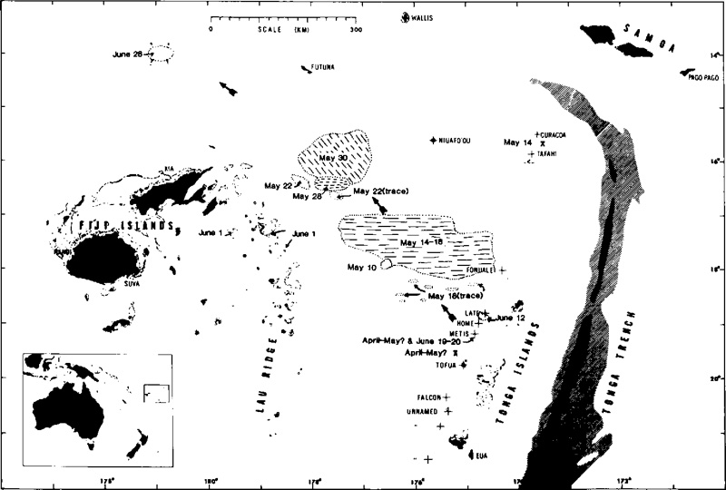 |
Figure 1. Map showing the distribution of floating pumice between Tonga and Fiji, and the locations of volcanic activity in Tonga, May-June 1979. Historically active volcanic centers are indicated by crosses. Stippled zones delineate water < 1 km deep. Trench depths > 6 and 8 km are indicated by diagonal and cross-ruled patterns. Original map by T. Simkin adapted by Woodhall (1979). |
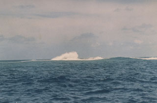
The source of the pumice remains uncertain. In mid-May, streaks of pumice extended back to Late Island from the main raft and the island's cone was covered with white material, which was thought to be fresh ash (04:05). However, activity has been reported at three other sites along the Tonga Arc in May and June.
A Tongan vessel reported a strong eruption between 0700 and 1200 on 19 June at 19.18°S, 174.83°W, in the area of Metis Shoal, a frequently active submarine volcano that last erupted December 1967-January 1968. The vessel's crew observed a mushroom cloud climbing to about 1.5 km and saw the sea steaming. At about the same time, the MV Niuvakai (enroute from Auckland, New Zealand to Samoa) passed Metis Shoal, reporting an eruption column a little less than 200 m high at 0754. Captain Robert Jones of Air Tonga flew over Metis Shoal late the next morning and saw rocks ejected to about 150 m altitude as water boiled vigorously around the center of the eruption. During subsequent flights, Captain Jones observed a growing area of tephra, either an island or a mass of floating pumice, around the eruption site. He estimated its diameter at 3 km on 21 June, 8 km on 22 June, and 16 km on 24 June.
Many moderate seismic events, most shallow, occur each month in the Tonga Arc. Events, in table 1, recorded by the worldwide seismic net (WWSSN) between late April and early June, had epicenters near one of the reported eruption sites. Data are from the USGS-NEIS, published in their Preliminary Determination of Epicenters.
Table 1. Events recorded by WWSSN between late April and early June 1979 with epicenters near one of the reported eruption sites. Data are from the USGS-NEIS, published in their Preliminary Determination of Epicenters.
| Date | Time (GMT) | Magnitude | Latitude | Longitude | Focus Depth | Number of Stations |
| 28 Apr 1979 | 0054 | 5.7 | 18.136°S | 174.855°W | shallow | 93 |
| 28 Apr 1979 | 0303 | 5.2 | 19.252°S | 175.669°W | 244 km | 101 |
| 29 Apr 1979 | 0851 | 4.7 | 15.906°S | 173.046°W | shallow | 33 |
| 06 May 1979 | 0907 | -- | 15.932°S | 173.882°W | shallow | 25 |
| 12 May 1979 | 2332 | 4.2 | 16.347°S | 174.325°W | 282 km | 8 |
| 28 May 1979 | 0003 | 5.3 | 17.512°S | 175.187°W | 274 km | 81 |
| 30 May 1979 | 1645 | 5.1 | 15.390°S | 173.174°W | shallow | 39 |
| 01 Jun 1979 | 0210 | 5.0 | 15.398°S | 173.180°W | shallow | 69 |
| 01 Jun 1979 | 2057 | 4.7 | 20.340°S | 173.799°W | shallow | 38 |
A research vessel, carrying geologists from Fiji and Tonga, left Fiji on 3 July. Each of the reported eruption sites along the Tonga Arc will be investigated and pumice floating in the area will be sampled.
Many moderate seismic events, most shallow, occure each month in the Tonga Arc. Nine events between 28 April and 1 June had epicenters near one of the reported eruption sites (table 1).
Further Reference. Woodhall, D., 1979, Cruise of the R.V. Bulikula to Investigate Recent Volcanic Activity in Tonga, July 11-18, 1979; Fiji Ministry of Lands & Mineral Resources, Mineral Resources Division Report 14.
Geological Summary. Lateiki, previously known as Metis Shoal, is a submarine volcano midway between the islands of Kao and Late that has produced a series of ephemeral islands since the first confirmed activity in the mid-19th century. An island, perhaps not in eruption, was reported in 1781 and subsequently eroded away. During periods of inactivity following 20th-century eruptions, waves have been observed to break on rocky reefs or sandy banks with depths of 10 m or less. Dacitic tuff cones formed during the eruptions in 1967 and 1979 were soon eroded beneath the ocean surface. An eruption in 1995 produced an island with a diameter of 280 m and a height of 43 m following growth of a lava dome above the surface.
Information Contacts: R. Richmond, Mineral Resources Dept., Fiji; J. Latter, DSIR, Wellington; S. Tongilava, Lands Survey and Natural Resources, Tonga; R. Jones, Air Tonga; USGS/NEIS, Denver; AP