Report on Lateiki (Tonga) — October 1979
Scientific Event Alert Network Bulletin, vol. 4, no. 10 (October 1979)
Managing Editor: David Squires.
Lateiki (Tonga) Pumice sighted in Solomons and New Hebrides
Please cite this report as:
Global Volcanism Program, 1979. Report on Lateiki (Tonga) (Squires, D., ed.). Scientific Event Alert Network Bulletin, 4:10. Smithsonian Institution. https://doi.org/10.5479/si.GVP.SEAN197910-243070
Lateiki
Tonga
19.18°S, 174.87°W; summit elev. 43 m
All times are local (unless otherwise noted)
Floating pumice, presumably from the recent island-forming eruption of Metis Shoal, was reported at two widely separated locations during October. On 6 October, Samuel Iko, aboard the MV Independence, observed a blanket of pumice floating between the islands of Guadalcanal, the Florida Group, and Malaita (Solomon Islands), with the greatest concentration at about 9.5°S, 160.5°E, approximately 3,000 km WNW of Metis Shoal. Other reports indicated that pumice washed ashore at Marau, an islet at 8.5°S, 159.5°E, as the raft moved southward through the Solomons.
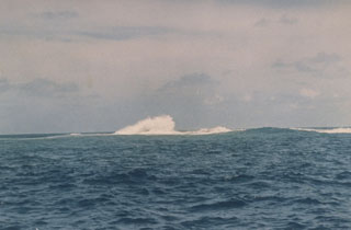
On 25 October, John Carney sighted dark friable pumice on the beach on the S coast of Efate Island, New Hebrides (17.8°S, 168.5°E), about 1,850 km W of Metis Shoal. This is the first known observation of pumice from Metis Shoal in Vanuatu. The last observations of Late Iki, the island that formed over Metis Shoal, were made in early October. At that time, the island had nearly disappeared beneath the ocean's surface.
Geological Summary. Lateiki, previously known as Metis Shoal, is a submarine volcano midway between the islands of Kao and Late that has produced a series of ephemeral islands since the first confirmed activity in the mid-19th century. An island, perhaps not in eruption, was reported in 1781 and subsequently eroded away. During periods of inactivity following 20th-century eruptions, waves have been observed to break on rocky reefs or sandy banks with depths of 10 m or less. Dacitic tuff cones formed during the eruptions in 1967 and 1979 were soon eroded beneath the ocean surface. An eruption in 1995 produced an island with a diameter of 280 m and a height of 43 m following growth of a lava dome above the surface.
Information Contacts: D. Tuni, Ministry of Natural Resources, Solomon Islands; J. Carney, A. MacFarlane, Geological Survey, Vanuatu; R. Richmond, Mineral Resources Dept., Fiji.