Report on Dukono (Indonesia) — January 1980
Scientific Event Alert Network Bulletin, vol. 5, no. 1 (January 1980)
Managing Editor: David Squires.
Dukono (Indonesia) Explosive activity continues
Please cite this report as:
Global Volcanism Program, 1980. Report on Dukono (Indonesia) (Squires, D., ed.). Scientific Event Alert Network Bulletin, 5:1. Smithsonian Institution. https://doi.org/10.5479/si.GVP.SEAN198001-268010
Dukono
Indonesia
1.6992°N, 127.8783°E; summit elev. 1273 m
All times are local (unless otherwise noted)
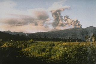
VSI personnel visited Dukono in August 1979. Explosive activity had increased since the previous visit 13 months earlier. Ash was ejected every 9-15 minutes but there were no audible detonations.
Further Reference. Kusumadinata, K., 1977, Data on the Dukono volcano: Berita Direktorat Geologi, v. 9, no. 16, p. 183.
Geological Summary. The Dukono complex in northern Halmahera is on an edifice with a broad, low profile containing multiple peaks and overlapping craters. Almost continuous explosive eruptions, sometimes accompanied by lava flows, have occurred since 1933. During a major eruption in 1550 CE, a lava flow filled in the strait between Halmahera and the Gunung Mamuya cone, 10 km NE. Malupang Wariang, 1 km SW of the summit crater complex, contains a 700 x 570 m crater that has also had reported eruptions.
Information Contacts: A. Sudradjat and L. Pardyanto, VSI; D. Shackelford, Brea, CA.

