Report on Babuyan Claro (Philippines) — February 1980
Scientific Event Alert Network Bulletin, vol. 5, no. 2 (February 1980)
Managing Editor: David Squires.
Babuyan Claro (Philippines) Hot mudflows force evacuation
Please cite this report as:
Global Volcanism Program, 1980. Report on Babuyan Claro (Philippines) (Squires, D., ed.). Scientific Event Alert Network Bulletin, 5:2. Smithsonian Institution. https://doi.org/10.5479/si.GVP.SEAN198002-274030
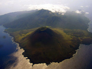
Babuyan Claro
Philippines
19.524°N, 121.95°E; summit elev. 1064 m
All times are local (unless otherwise noted)
Hot mudflows from Babuyan Claro [but see below] damaged rice fields and roads, and forced the evacuation of nearby residents according to a Kyodo radio report dated 8 February. PNA radio reported that a three-man COMVOL was sent to study the volcano. . . .
Geological Summary. Multiple Quaternary volcanic centers occupy Babuyan de Claro Island north of Luzon. The largest edifice is Babuyan Claro (Mount Pangasun) at the center of the island, a stratovolcano with a 500-m-diameter summit crater and a smaller crater on the upper E flank. An older edifice lies just 1.5 km WSW, but the basaltic andesite Smith volcano (Mount Babuyan), about 4 km ENE of the summit, is the youngest volcanic feature on the island. Eruptions from Smith were recorded most recently during 1907-1924. Askedna Hot Spring is located at the southern base of Babuyan Claro.
Information Contacts: Kyodo radio, Tokyo; PNA radio, Manila.