Report on Karkar (Papua New Guinea) — April 1980
Scientific Event Alert Network Bulletin, vol. 5, no. 4 (April 1980)
Managing Editor: David Squires.
Karkar (Papua New Guinea) Phreatic explosions followed by shrinking crater lake
Please cite this report as:
Global Volcanism Program, 1980. Report on Karkar (Papua New Guinea) (Squires, D., ed.). Scientific Event Alert Network Bulletin, 5:4. Smithsonian Institution. https://doi.org/10.5479/si.GVP.SEAN198004-251030
Karkar
Papua New Guinea
4.647°S, 145.976°E; summit elev. 1839 m
All times are local (unless otherwise noted)
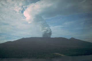
"Observations from Kinim Observatory indicated only weak white vapour emission during March. Inspections of crater activity on 11, 12, and 24 March indicated that phreatic explosions were continuing from several sources in the lake occupying the 1979 crater. These events, occurring at intervals of a few minutes on 11 March, involved updoming of the lake surface and projection of spear-headed columns of dark crater-floor mud to heights of about 20 m. The lake, occupying the W half of the crater floor, was a uniform pale brown colour, and steam emission from the lake surface was profuse. Fumarolic activity from the walls of the crater continued unchanged, but fumaroles on Bagiai Cone and the caldera floor were weaker. The E crater margin had migrated 3-5 m by collapse of the crater wall, leaving a near-vertical escarpment.
"No changes were observed in summit emissions in April. An aerial inspection on 26 April revealed that only a small pond remained in the base of the 1979 crater, on its W side. About 6 closely spaced vents on the crater floor were releasing white emissions under low to moderate pressure. The floor of the crater was flat and smooth. From the air, white sublimates on the E wall of the crater appeared quite conspicuous. Fumaroles on the caldera floor continued to show weak activity, but those on Bagiai may have strengthened since late March.
"Gravity measurements in March suggested that a deflationary trend indicated in January had eased. Seismic activity continued to show discrete events and traces of tremor recorded as irregular bands through April.
Geological Summary. Karkar is a 19 x 25 km forest-covered island that is truncated by two nested summit calderas. The 5.5 km outer caldera was formed during one or more eruptions, the last of which occurred 9,000 years ago. The steep-walled 300-m-deep, 3.2 km diameter, inner caldera was formed sometime between 1,500 and 800 years ago. Cones are present on the N and S flanks of this basaltic-to-andesitic volcano; a linear array of small cones extends from the northern rim of the outer caldera nearly to the coast. Recorded eruptions date back to 1643 from Bagiai, a pyroclastic cone constructed within the inner caldera, the floor of which is covered by young, mostly unvegetated andesitic lava flows.
Information Contacts: C. McKee, RVO.

