Report on St. Helens (United States) — April 1980
Scientific Event Alert Network Bulletin, vol. 5, no. 4 (April 1980)
Managing Editor: David Squires.
St. Helens (United States) Major uplift on N flank; explosions end
Please cite this report as:
Global Volcanism Program, 1980. Report on St. Helens (United States) (Squires, D., ed.). Scientific Event Alert Network Bulletin, 5:4. Smithsonian Institution. https://doi.org/10.5479/si.GVP.SEAN198004-321050
St. Helens
United States
46.2°N, 122.18°W; summit elev. 2549 m
All times are local (unless otherwise noted)
Numerous debris flows descended the N and E flanks early in the eruption, reaching nearly to timberline in some areas. These were composed of ice blocks and sparse blocks of rock in a matrix of dark-colored mixed ash and snow. Non-incandescent ash avalanches occasionally flowed down the flanks during the early part of the eruption.
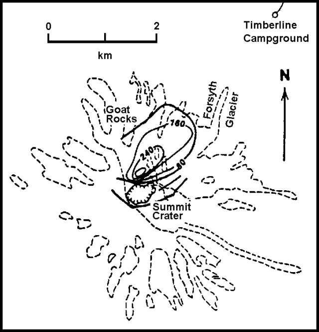
By 8 April, the two initially separate active vents had coalesced into a single crater (figure 2), at least 500 m long x 350 m wide. The crater had deepened to 300 m by 12 April and sometimes contained small quantities of water or ice. Most mid-April eruption clouds were small and consisted primarily of vapor, but ash-rich clouds were occasionally ejected to 1 km or more above the summit. Large ice blocks were sometimes included in the ejecta. The tiltmeter at Timberline, about 4 km NE of the summit, recorded episodes of deformation of as much as a few tens of µrad in a few minutes to a few hours but these episodes oscillated between uplift and subsidence, resulting in little or no net tilt. Periods of uplift appeared to precede explosions, which were followed by subsidence. Explosions decreased in size and ash content through mid-April, with the last confirmed ejection of ash on 22 April. No fresh magma has been identified in any of the ejecta. Episodic explosions were replaced by continuous steaming, which was continuing in early May.
A comparison by James Moore of the 1952 topographic map of Mt. St. Helens with airphotos taken 7 and 12 April 1980 indicated that a substantial net uplift had taken place on the upper N flank. Cartographers from the USGS National Mapping Division comparing August 1979 airphotos with the April 1980 sets confirmed Moore's findings, delineating a feature with an area of nearly 4 km2 that had risen at least 25 m and had a maximum uplift of about 100 m. [D. Swanson notes that the "uplift" was more apparent than real. It resulted from horizontal displacement of high terrain over low terrain, not vertical displacement of the low terrain.] Subsequent geodimeter readings showed that one area of the uplift had [moved outward] as much as 6 m 24-29 April.
The upper portion of Forsyth Glacier has been extensively distended and cracked by the uplift, and USGS personnel warned of the danger of a major avalanche down the N or NE flank. As a result, Washington's Governor Ray ordered the entire Spirit Lake area N and NE of the volcano, plus the zone immediately W and S of the volcano, closed to all but government workers and scientists. Access to a second zone, extending 8 km beyond the inner zone, was allowed to landowners during daylight hours only. About 300 loggers and 60 permanent residents of the area around Spirit Lake had been evacuated earlier, just after the initial explosions in late March.
The arcuate fissures described last month defined a graben extending more than 3 km through the summit, including the active crater. Both ends of the graben died out as gentle sags after wrapping around the uplift just to the N. The graben contained a median fault, E of and trending toward the active crater. This fault was downdropped on the N side by an amount estimated by Hopson and Melson at less than 30 m. Total subsidence of the graben was difficult to estimate because of its proximity to the uplift.
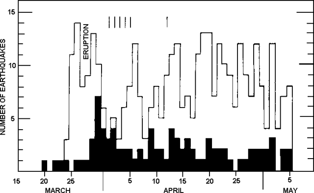
Although the number of local earthquakes has fluctuated (figure 3), total seismic energy release has remained relatively constant through the eruption. Refinement of the crustal model used to locate the earthquakes has clustered the hypocenters beneath the volcano, 1-10 km below the summit. No tremor has been recorded since 12 April.
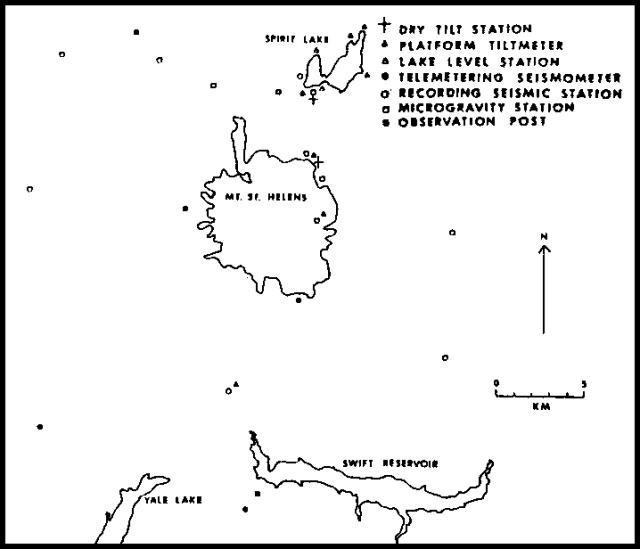
The USGS continues to monitor the activity in cooperation with the University of Washington, the United States Forest Service (USFS), and others. Numerous instruments, including seismographs, tiltmeters, and gravimeters have been placed around the volcano (figure 4), supplementing continuing visual observations from ground stations and aircraft.
 |
Figure 4. Monitoring equipment around Mt. St. Helens as of mid-April 1980. Data provided by Robert Tilling. |
Geological Summary. Prior to 1980, Mount St. Helens was a conical volcano sometimes known as the Fujisan of America. During the 1980 eruption the upper 400 m of the summit was removed by slope failure, leaving a 2 x 3.5 km breached crater now partially filled by a lava dome. There have been nine major eruptive periods beginning about 40-50,000 years ago, and it has been the most active volcano in the Cascade Range during the Holocene. Prior to 2,200 years ago, tephra, lava domes, and pyroclastic flows were erupted, forming the older edifice, but few lava flows extended beyond the base of the volcano. The modern edifice consists of basaltic as well as andesitic and dacitic products from summit and flank vents. Eruptions in the 19th century originated from the Goat Rocks area on the N flank, and were witnessed by early settlers.
Information Contacts: J. Moore and R. Christiansen, USGS, Menlo Park, CA; D. Mullineaux and D. Crandell, USGS, Denver, CO; R. Tilling, USGS, Reston, VA; C. Hopson, Univ. of California, Santa Barbara; W. Melson, SI; S. Malone, R. Crosson, and E. Endo, Univ. of Washington; Newport Geophysical Observatory.


