Report on St. Helens (United States) — July 1980

Scientific Event Alert Network Bulletin, vol. 5, no. 7 (July 1980)
Managing Editor: David Squires.
St. Helens (United States) Explosions destroy lava dome; 18 May cloud detected over Europe and Asia
Please cite this report as:
Global Volcanism Program, 1980. Report on St. Helens (United States) (Squires, D., ed.). Scientific Event Alert Network Bulletin, 5:7. Smithsonian Institution. https://doi.org/10.5479/si.GVP.SEAN198007-321050
St. Helens
United States
46.2°N, 122.18°W; summit elev. 2549 m
All times are local (unless otherwise noted)
An eruption similar to those of 25 May and 12 June destroyed the June dome on 22 July. After a slightly smaller eruption on 7 August, growth of a new dome began.
Activity was weak from late June through mid-July. A vapor plume rose to a maximum of 3.5-4 km altitude. SO2 emission, measured by remote sensing equipment, ranged from 1,800 to 2,600 t/d. No lava-dome growth was detected.
After several episodes of harmonic tremor on 27 June, weaker than the tremor preceding any of the eruptions, seismicity recorded by the USGS-University of Washington seismic net was limited to a few small shallow earthquakes per day. In an 11-minute period on 6 July, four earthquakes of M 2.0-3.2 occurred about 8 km below Marble Mountain, 14 km SE of Mt. St. Helens. The first of these shocks was recorded only 17 minutes after the start of an earthquake swarm beneath Mt. Hood, 100 km SSE of Mt. St. Helens (see Hood section). Six events of M 1.4-2.9, centered about 17 km SE of Mt. St. Helens, were recorded in 13.5 hours 19-20 July. A few hours later, one seismograph recorded 50 minutes of very weak harmonic tremor, the first since 27 June. On the day of the eruption, 22 July, shallow events centered under the N flank began at about 1000. Four earthquakes were recorded between 1400 and 1500, nine from 1500 to 1600, and twenty from 1600 to 1700. An increase in SO2 emission just prior to the eruption caused a sharp drop in the CO2/SO2 ratio after a steady increase over the preceding week.
The initial tephra ejection phase began at 1714 and lasted 6 minutes. NWS radar at Portland airport measured the top of the eruption cloud at slightly less than 14 km. Clear weather allowed the cloud to be seen from as far away as Seattle, Washington and Salem, Oregon, both about 150 km distant. An overflight by Donald Swanson revealed that the activity had blown a hole in the lava dome that had begun to grow in the crater shortly after the 12 June eruption, but had not destroyed it.
A second, larger, tephra cloud emerged from the volcano at 1825 and was fed vigorously for 22 minutes, destroying the lava dome. Pyroclastic flows moved down the N flank, nearly reaching Spirit Lake. A NOAA weather satellite infrared image at 1845 (2 minutes before the end of this active phase) yielded a temperature of -52°C at the top of the column, corresponding to an altitude of about 13 km (figure 12). Portland airport radar recorded a maximum cloud altitude of more than 18 km during this phase. Arthur Krueger estimates the base of the stratosphere to have been at about 16 km altitude.
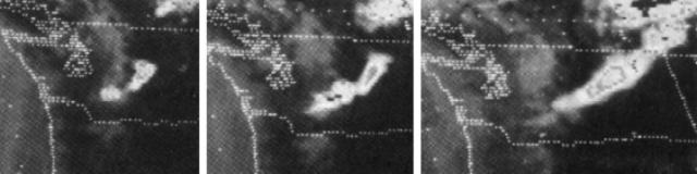 |
Figure 12. Series of three enhanced infrared images returned 22 July 1980 by NOAA's GOES West geostationary weather satellite. Left, image at 1845 shows the cloud from the Mt. St. Helens explosion at 1714 drifting NE as the column from the explosion that began at 1825 rises from the volcano. A temperature of -52°C at the top of the latter column was calculated from this image, corresponding to an altitude of about 13 km. Center, image 1 hour later, at 1945, shows material from the eruptive pulses that began at 1901 rising from the volcano, as two distinct earlier clouds move NE. Right, image at 2145 shows that feeding of the cloud has nearly ended, and the distal end of the plume has crossed into Canada at the NE corner of Washington. Courtesy of Arthur Krueger and Andy Horvitz. |
The final series of eruptive pulses began at 1901, lasting about 2 hours and 40 minutes. The highest cloud ejected during this period reached almost 14 km at 1907 and pyroclastic flows were most numerous around that time. NOAA weather satellite images show that feeding of the eruption column had declined substantially by 2115, and that the ash plume was definitely detached from Mt. St. Helens on the next image, at 2145. The plume moved NE across Washington into British Columbia, Canada, remaining visible on the images until about 0100, when it merged with a cold front over W Alberta. Ash fell as far away as Montana and Alberta. Ashfalls were light, the thickest reported at Colville, Washington (nearly 450 km NE of Mt. St. Helens) where 1.5 mm were measured.
The USGS informed federal, state, and local government agencies of the earthquake swarm during the early afternoon of 22 July. People working on the flanks of the volcano, including about 120 USFS personnel, wereevacuated before eruptive activity began. No casualties were reported.
Gary Heckman reports that a class M-8 solar flare that occurred on 22 July began 37 minutes after the volcano's first explosion (at 1751), peaked at 1803, and ended at 1909. Class M-8 flares, near the top of the intermediate intensity scale, normally occur about once a month. However, solar activity is presently near the peak of its 22-year cycle and intense flares have become more frequent.
Aerial observers reported glowing red areas in the crater during the night of 22-23 July. Overflights the next morning revealed a new crater, about 250-300 m in longest dimension and 100 m deep, in the area formerly occupied by the lava dome. A thick blanket of ash surrounded the new crater, which emitted a small vapor column similar to those of mid-July. SO2 emission dropped to about 800 t/d on 23 July, but returned to mid-July levels the following day. Temperatures of up to 705°C were measured at 1.5 m depth in the new pyroclastic flows on 24 July, while surface temperatures were 70-80°C.
On 28 July at 0608, a little ash rose slowly from the new crater to 3.5 km altitude. Harmonic tremor accompanied the activity, which lasted about 20 minutes. No unusual pre-eruption seismicity was recorded, but glow was observed a few hours earlier from a USFS monitoring aircraft.
SO2 emission dropped to 700 t/d on 28 July and did not exceed 1,100 t/d through the end of the month. Red glow continued to be visible in the crater as of early August. The USGS attributed the glow to superheated rock, not a new lava dome.
At press time, another eruption was followed by renewed lava-dome growth. At about noon on 7 August, volcanic tremor began, increasing in intensity as a M 2.3 earthquake occurred at 1238 in the vicinity of Marble Mountain, site of earthquakes in early and mid-July. Remote sensing of CO2 and SO2 gas emissions showed that the CO2/SO2 ratio had dropped from twelve to fourteen on 6 August to about three on 7 August. However, the lower ratio was caused by a decrease in CO2 rather than the increased SO2 emission that caused the similar ratio decline before the 22 July eruption. Because of the changes in seismicity and gas emission, the USGS withdrew its personnel from the area closest to the volcano and notified the USFS Emergency Coordination Center that an eruption might be imminent. Other persons working on the volcano's flanks were evacuated, including fire fighters battling persistent smoldering debris in the 18 May eruption deposits.
Tremor intensity continued to increase, and another M 2.3 earthquake was recorded in the Marble Mountain area at 1458. An eruption began at 1623, producing an ash-laden column that rose quickly to about 13.5 km. A small pyroclastic flow moved down the N flank, leaving a thin deposit, but did not reach Spirit Lake. At 1910, an increase in tremor amplitude coincided with a series of pulsating ash ejections that sent clouds to a maximum altitude of less than 7 km. Seismic and eruptive activity waned briefly about 2200, then a stronger explosion at 2232 sent tephra to 11 km altitude, accompanied by more tremor. Variable winds sent ash over a wide area, but ashfalls were very light. Ash was reported in Grays Harbor County, about 150 km NW; Mt. Vernon, 250 km N; Wenatchee, 200 km NE; and Portland, 80 km SW. Small pulses were seen on the USGS monitoring camera the next day at 0935, 1007, and 1734. Ash rose to about 3.5 km altitude as surrounding steam columns reached nearly 5 km. A new lava dome was visible in the vent on 8 August, with its top about 40 m below the vent rim. About 8 m of vertical growth appeared to have taken place by 9 August, but no further growth was evident on 11 August.
Tracking of the 18 May eruption cloud continues at several locations worldwide. Ronald Fegley reported that NOAA's lidar equipment at Mauna Loa, Hawaii (19.5°N, 155.6°W) detected a significant volcanic layer at 18.4 km altitude on 15 July. Weaker layers had been detected on 10 and 13 June and 2 and 8 July at similar altitudes.
M.P. McCormick provided the following information. On 4 June, the ground-based lidar at NASA's Langley Research Center in SE Virginia (37°N, 76.4°W) first detected a persistent layer at 18 km altitude (no data were obtained 30 May-3 June). H. Jäger and R. Reiter observed layers near 12 km altitude (slightly above the local tropopause) over Garmisch-Partenkirchen, Germany (47.5°N, 11.0°E) on several days beginning on 25 May. Material extending from 13 to 15.5 km altitude was detected there on 12 June. Beginning 11 June, G. Visconti and G. Fiocco reported material between 15 and 20 km, and possibly at 14 km, over L'Aquila, Italy (42.4°N, 13.4°E). M. Fujiwara of Kyushu University, Japan (33.6°N, 130.4°E) reported a layer on 3 June just below 15 km, clearly higher than the local tropopause. NASA's SAGE satellite will move through the mid-latitudes of the northern hemisphere in August and will collect data on ejecta remaining in the atmosphere. H.H. Lamb reports that he observed a colored ring, which he believes to be an example of Bishop's Ring, around the sun at sunset on 12 June at Norwich, England (52.6°N, l.3°E).
Issue No. 80-3 of the Upper Atmospheric Programs Bulletin, published jointly by NASA and the FAA, contains ten pages of reports of high-altitude atmospheric research and satellite study of the 18 May eruption cloud.
JMA reports that many of their stations, from the NE to the SW ends of Japan, recorded the pressure wave from the 18 May explosion on microbarometers. Arrivals ranged from 1447 to about 1628 (local time at Mt. St. Helens) on 18 May. Calculated apparent wave velocities ranged from 305 to 309 m/s.
Strong electrical effects were associated with the heavy ashfall of 18 May. Rocke Koreis reported observations of ball lightning at elevations from near ground level into the ash cloud over Yakima, Washington (140 km ENE of the volcano). Strong thunder continued throughout Yakima's ashfall, which was entirely dry and lasted from 1115 to 2300 on 18 May. A distinct second pulse of ash was noted in late afternoon. Koreis also reported that a light plane fleeing the initial 18 May explosion at an air-speed of more than 270 km/hr was briefly being overtaken by the eruption cloud moving at an estimated 320 km/hr.
Geological Summary. Prior to 1980, Mount St. Helens was a conical volcano sometimes known as the Fujisan of America. During the 1980 eruption the upper 400 m of the summit was removed by slope failure, leaving a 2 x 3.5 km breached crater now partially filled by a lava dome. There have been nine major eruptive periods beginning about 40-50,000 years ago, and it has been the most active volcano in the Cascade Range during the Holocene. Prior to 2,200 years ago, tephra, lava domes, and pyroclastic flows were erupted, forming the older edifice, but few lava flows extended beyond the base of the volcano. The modern edifice consists of basaltic as well as andesitic and dacitic products from summit and flank vents. Eruptions in the 19th century originated from the Goat Rocks area on the N flank, and were witnessed by early settlers.
Information Contacts: R. Decker, HVO, Hawaii; R. Tilling, C. Zablocki, USGS, Reston, VA; D. Swanson, R. Christiansen, USGS, Menlo Park, CA; A. Krueger, NOAA/NESS; S. Malone, R. Crosson, E. Endo, University of Washington; M.P. McCormick, NASA Langley Research Center; R. Fegley, NOAA/ERL; H. Jäger, Fraunhofer-Institut für Atmosphärische Umweltforschung; G. Visconti, University dell'Aquila; G. Fiocco, Istituto di Fisica dell'Atmosfera; M. Fujiwara, Kyushu University; H.H. Lamb, University of East Anglia; Seismological Division, JMA; W.S. Smith, FAA; R.Koreis, Yakima, WA; AP; UPI.