Report on Hood (United States) — July 1980

Scientific Event Alert Network Bulletin, vol. 5, no. 7 (July 1980)
Managing Editor: David Squires.
Hood (United States) Earthquake swarm
Please cite this report as:
Global Volcanism Program, 1980. Report on Hood (United States) (Squires, D., ed.). Scientific Event Alert Network Bulletin, 5:7. Smithsonian Institution. https://doi.org/10.5479/si.GVP.SEAN198007-322010
Hood
United States
45.374°N, 121.695°W; summit elev. 3426 m
All times are local (unless otherwise noted)
[Seismic data in the following report have been extensively modified using Rite and Iyer (1981).] A series of earthquakes in the vicinity of Mt. Hood, about 100 km SSE of Mt. St. Helens, began with a M [2.8] shock on 6 July at 1817. [Within 30 minutes, 7 events of M 1.6-2.8 occurred in the vicinity of the first shock. Depths were tightly clustered at 4-7 km.]
[Activity remained anomalously high for about 48 hours after the initial shock, with 40 events recorded on 3-9 stations in the first 24 hours (figure 1). Epicenters were generally on the S flank (figure 2).] A M [2.44] earthquake at 0259 and a M [2.25] event at 1315 were centered [near the summit] at [5.9 and 5.3] km depth. [Between 6-16 July, 143 small events were recorded on a single station (VHE) about 5 km SE of the summit. About 50 were correlated with nearby stump blasting, but the other 90 appeared to be swarm events, most with coda magnitudes less than 0.5.]... The swarm's total seismic energy release [was about 8 x 10¹⁵ ergs]....
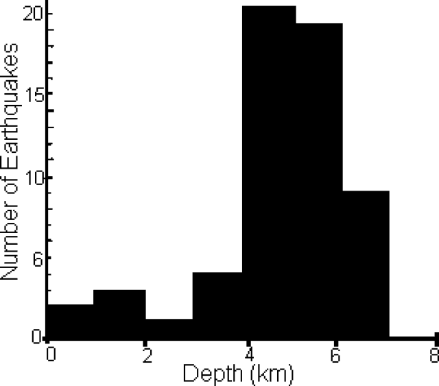 |
Figure 1. Histogram of seismic activity at Mt. Hood, 6-20 July 1980, after Rite and Iyer (1981). |
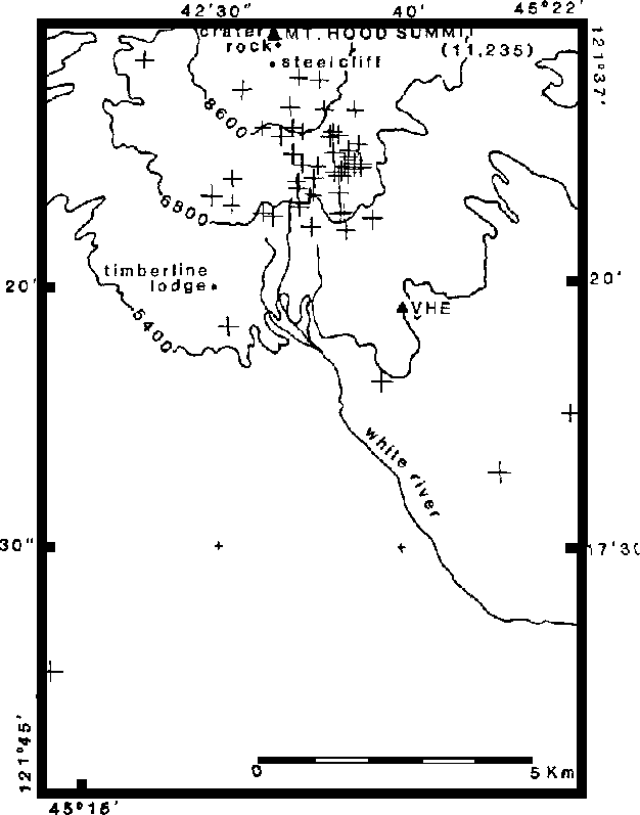 |
Figure 2. Epicenters of most of the July 1980 events at Mt. Hood. Sizes of crosses are proportional to event magnitudes. After Rite and Iyer (1981). |
The USGS issued a hazard watch formally notifying government officials. On 11 July, the USGS and the University of Washington installed three portable seismographs on Mt. Hood. No harmonic tremor has been recorded, and no new surface activity has been observed. Gas analyses made from aircraft on 11 July showed no increase in atmospheric SO2 or CO2 above normal levels.
Because no additional seismicity and no new eruptive activity have occurred at Mt. Hood, the USGS ended the hazard watch on 5 August.
References. Rite, A., and Iyer, H.M., 1981, July 1980 Mt. Hood earthquake swarm: USGS Open File Report 81-48, 22 p.
Geological Summary. Mount Hood, Oregon's highest peak, forms a prominent backdrop to the city of Portland. The eroded summit area consists of several andesitic or dacitic lava domes. Major Pleistocene edifice collapse produced a debris avalanche and lahar that traveled north down the Hood River valley and crossed the Columbia River. The glacially eroded volcano has had at least three major eruptive periods during the past 15,000 years. The last two occurred within the past 1,800 years from the central vent high on the SW flank and produced deposits that were distributed primarily to the south and west along the Sandy and Zigzag rivers. The last major eruptive period took place beginning in 1781 CE, when growth of the Crater Rock lava dome was accompanied by pyroclastic flows and lahars down the White and Sandy rivers. The Sandy River lahar deposits extended to the west as far as the Columbia River and were observed by members of the 1804-1805 Lewis and Clark expedition shortly after their emplacement. Minor 19th-century eruptions were witnessed from Portland.
Information Contacts: R. Decker, R. Tilling, and C. Zablocki, USGS; S. Malone, R. Crosson, and E. Endo, Univ. of Washington.