Report on Gareloi (United States) — August 1980
Scientific Event Alert Network Bulletin, vol. 5, no. 8 (August 1980)
Managing Editor: David Squires.
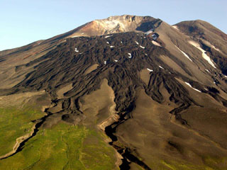
Gareloi (United States) Tephra cloud from summit crater
Please cite this report as:
Global Volcanism Program, 1980. Report on Gareloi (United States) (Squires, D., ed.). Scientific Event Alert Network Bulletin, 5:8. Smithsonian Institution. https://doi.org/10.5479/si.GVP.SEAN198008-311070
Gareloi
United States
51.79°N, 178.794°W; summit elev. 1573 m
All times are local (unless otherwise noted)
During an overflight on 8 August, USN pilot Edwin Beech saw vapor rising to about 1 km above the summit crater. The next day, a Northwest Orient Airlines pilot observed a steam and ash column that reached 10.5 km altitude and was blown NNW, away from inhabited areas. Poor weather obscured the summit for the next several days, although large eruption columns would have been visible above the cloud layer from passing aircraft.
On 13 August, USN pilots were able to see the top 300 m of the volcano. A light gray eruption cloud that appeared to originate from the NE quadrant of the summit crater rose to about 2.5 km altitude (1 km above the summit), depositing ash to the NW. Both Lt. Beech and David Evans, who operates the USGS seismic station on nearby Adak Island, felt that the summit area had changed significantly during the eruption.
By 23-24 August, the activity had declined to weak vapor emission. No lava flows have been observed. Gareloi's last reported eruption was in January 1952.
Geological Summary. The 8 x 10 km Gareloi Island, the northernmost volcano of the Delarof Group at the western end of the Andreanof Islands, consists of a stratovolcano with two summits and a prominent SE-trending fissure. The fissure was formed during an eruption in 1929 and extends from the southern summit to the sea. Steep sea cliffs that are cut into rocks of an older, eroded center are found on the SW coast, and submarine deposits of three debris avalanches produced by edifice collapse are found offshore. Young lava flows cover the older volcano from the summit to the coast along three broad axes trending NW, ENE, and S. The 1929 eruption originated from 13 craters along a 4-km-long fissure. Phreatic explosions were followed by the ejection of glassy pumice, lapilli, scoria, and older blocks, as well as by the emission of four short, steep lava flows, one of which reached the SE coast.
Information Contacts: T. Miller, USGS, Anchorage; Lt. E. Beech, U.S. Navy, Adak Island; D. Evans, USGS, Adak Island.