Report on Gareloi (United States) — November 1980
Scientific Event Alert Network Bulletin, vol. 5, no. 11 (November 1980)
Managing Editor: David Squires.
Gareloi (United States) Aircraft samples stratospheric plume
Please cite this report as:
Global Volcanism Program, 1980. Report on Gareloi (United States) (Squires, D., ed.). Scientific Event Alert Network Bulletin, 5:11. Smithsonian Institution. https://doi.org/10.5479/si.GVP.SEAN198011-311070
Gareloi
United States
51.79°N, 178.794°W; summit elev. 1573 m
All times are local (unless otherwise noted)
On 10 and 11 August, SO2 from a fresh volcanic plume was detected from a research aircraft (flown by NASA under contract from the U.S. Department of Energy) at 19.2 km altitude just S of Anchorage Alaska.
Imagery returned 8 August at 1010 by the NOAA 6 satellite shows a high-altitude plume appearing to originate from the vicinity of Gareloi. Using a drift rate of 30 km/hour, Los Alamos National Laboratory (LANL) personnel calculated that the eruption that produced this plume had probably ended about 10 hours earlier. Later visual and infrared images show the plume moving toward the Anchorage area, about 2,000 km from Gareloi, at a rate that could have brought it to the sampling area by 10 August. The eruption column seen emerging from Gareloi 9 August by a commercial pilot was also present on satellite images, but clearly was not large enough and did not reach a high enough altitude to have been the source of the material sampled 10-11 August. Wind conditions also preclude the 7 August eruption clouds from Mt. St. Helens as a source for SO2 in the Anchorage area at this time.
Further Reference. Sedlacek, W.A., Mroz, E.J., and Heiken, G., 1981, Stratospheric sulfate from the Gareloi eruption, 1980: contribution to the "ambient" aerosol by a poorly documented volcanic eruption: Geophysical Research Letters, v. 8, p. 761-764.
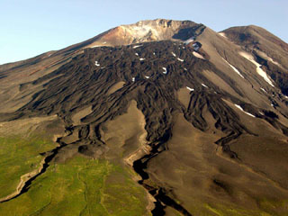
Geological Summary. The 8 x 10 km Gareloi Island, the northernmost volcano of the Delarof Group at the western end of the Andreanof Islands, consists of a stratovolcano with two summits and a prominent SE-trending fissure. The fissure was formed during an eruption in 1929 and extends from the southern summit to the sea. Steep sea cliffs that are cut into rocks of an older, eroded center are found on the SW coast, and submarine deposits of three debris avalanches produced by edifice collapse are found offshore. Young lava flows cover the older volcano from the summit to the coast along three broad axes trending NW, ENE, and S. The 1929 eruption originated from 13 craters along a 4-km-long fissure. Phreatic explosions were followed by the ejection of glassy pumice, lapilli, scoria, and older blocks, as well as by the emission of four short, steep lava flows, one of which reached the SE coast.
Information Contacts: W. Sedlacek, G. Heiken, and E. Mroz, LANL.