Report on Kadovar (Papua New Guinea) — March 1981
Scientific Event Alert Network Bulletin, vol. 6, no. 3 (March 1981)
Managing Editor: Lindsay McClelland.
Kadovar (Papua New Guinea) Discolored water
Please cite this report as:
Global Volcanism Program, 1981. Report on Kadovar (Papua New Guinea) (McClelland, L., ed.). Scientific Event Alert Network Bulletin, 6:3. Smithsonian Institution. https://doi.org/10.5479/si.GVP.SEAN198103-251002
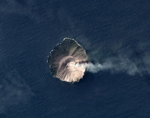
Kadovar
Papua New Guinea
3.608°S, 144.588°E; summit elev. 365 m
All times are local (unless otherwise noted)
"An area of orange discolouration of the sea at the NE shore was observed during aerial inspections on 6 and 19 March. Previously (1976-77) sea discolouration was present at the S shore and was related to the development of a new thermal area on the S flank of the island. This thermal area was now observed to have been reduced in size by regrowth of vegetation."
Geological Summary. The 2-km-wide island of Kadovar is the emergent summit of a Bismarck Sea stratovolcano of Holocene age. It is part of the Schouten Islands, and lies off the coast of New Guinea, about 25 km N of the mouth of the Sepik River. Prior to an eruption that began in 2018, a lava dome formed the high point of the andesitic volcano, filling an arcuate landslide scarp open to the south; submarine debris-avalanche deposits occur in that direction. Thick lava flows with columnar jointing forms low cliffs along the coast. The youthful island lacks fringing or offshore reefs. A period of heightened thermal phenomena took place in 1976. An eruption began in January 2018 that included lava effusion from vents at the summit and at the E coast.
Information Contacts: Acting Senior Volcanologist, RVO.