Report on Alaid (Russia) — May 1981
Scientific Event Alert Network Bulletin, vol. 6, no. 5 (May 1981)
Managing Editor: Lindsay McClelland.
Alaid (Russia) April-May eruption detailed
Please cite this report as:
Global Volcanism Program, 1981. Report on Alaid (Russia) (McClelland, L., ed.). Scientific Event Alert Network Bulletin, 6:5. Smithsonian Institution. https://doi.org/10.5479/si.GVP.SEAN198105-290390
Alaid
Russia
50.861°N, 155.565°E; summit elev. 2285 m
All times are local (unless otherwise noted)
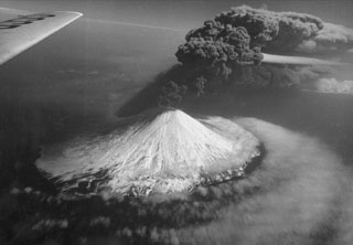
G.S. Steinberg provided the following additional information on the early stages of the eruption. Activity began 27 April with the emission of a small white plume. The magnitude of the explosions increased rapidly, soon building a black ash column more than 10 km high. Ashfall was intense at Severokurilsk (45 km ESE of the volcano), and by the end of 27 April as much as 20 cm had been deposited there. Schools and kindergartens were closed the next day and water collecting facilities were disrupted by the ash. The wind changed direction 29 April, blowing the eruption cloud NE. At Petropavlovsk, 300 km to the NE, an estimated 1.5 kg/m2 of ash had accumulated by the end of 29 April. The eruption reached its maximum intensity 30 April-1 May. Activity began to decrease 2 May, was limited to ejection of ash and larger tephra to less than 100 m height by 4-5 May, and stopped 7 May.
Michael Matson provided the following satellite data. Plumes of varying langths were intermittently present through late May on imagery (at about 0730 each day) from the NOAA 6 polar orbiting satellite. The minor activity reported by Steinberg after 2 May could not be seen on the images, but a small plume from Alaid appeared 7 May. On 8 May, a plume extended about 350 km from Alaid, but 24 hours later it was only about 60 km long. There was a plume on the 10 May imagery, but no activity was evident 11-14 May. A very small plume reappeared 15 May, had grown to 250 km long by the 17th, and persisted, at lengths that varied from 50 to nearly 600 km, through 27 May (weather clouds obscured the volcano 19 and 25 May). Alaid appeared to emit a plume no more than 25 km long on 1 June. No additional activity was evident on the satellite imagery through 9 June.
Further References. Fedotov, S.A., Ivanov, B.V., Avdeyko, G.P., Flerov, G, and others, 1981, The 1981 eruption of Alaid volcano: Volcanology and Seismology, 1981, no. 5, p. 82-87.
Sawada, Y., 1983, Analysis of eruption clouds by the 1981 eruptions of Alaid and Pagan volcanoes with GMS images: Papers in Meteorology and Geophysics, v. 34, p. 307-324.
Geological Summary. The highest and northernmost volcano of the Kuril Islands, Alaid is a symmetrical stratovolcano when viewed from the north, but has a 1.5-km-wide summit crater that is breached open to the south. This basaltic to basaltic andesite volcano is the northernmost of a chain constructed west of the main Kuril archipelago. Numerous pyroclastic cones are present the lower flanks, particularly on the NW and SE sides, including an offshore cone formed during the 1933-34 eruption. Strong explosive eruptions have occurred from the summit crater beginning in the 18th century. Reports of eruptions in 1770, 1789, 1821, 1829, 1843, 1848, and 1858 were considered incorrect by Gorshkov (1970). Explosive eruptions in 1790 and 1981 were among the largest reported in the Kuril Islands.
Information Contacts: G. Steinberg, Sakhalin Complex Institute; M. Matson, NOAA/NESS.